Spy Photos
15. Sudan, 2004
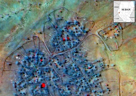
Commercial satellite imagery can identify ethnic cleansing and
humanitarian crises when "cued" (or supplied precise coordinates on
where to point a satellite) by other sources, including humanitarian
relief organizations and NGOs on the ground. Unfortunately, while
convincing to expert eyes, the images alone may not be persuasive
enough to help solve such crises. A glaring case in point is imagery
of Darfur released by the U.S. State Department in 2004 (above) and
by humanitarian groups in 2007, which has not succeeded in
motivating international organizations to apply the necessary
political pressure and sanctions on the Sudanese government to end
what appears to be genocide. In a case such as that in Darfur,
"ground-truth" imagery, when available from on-site sources, is
often more dramatic and thus more persuasive in making the case of
genocide than blurry images from orbit. In this detail from an image
of a destroyed village near Shataya in Darfur taken on June 21,
2004, black rings are foundations of destroyed huts, while red areas
indicate remaining healthy vegetation.