|
In a way, SAR is like a camera. But instead of using light to create
an image, SAR relies only on radar signals it sends out. This allows
it to produce images in total darkness. It also takes advantage of
radar's penetrating ability, allowing it to "see" through clouds,
rain, snow, and fog. Creating a SAR image, however, involves mounds
of data and tremendous computing power.
In general, radar works by measuring the time it takes a radio wave
to travel from an antenna to an object and back to the antenna.
Based on the time interval, radar calculates the distance to the
object. But this type of radar can only locate an object and assess
its speed. To create an image, a significantly greater amount of
data is needed, and that requires an extremely long
antenna—much longer than any plane could carry. SAR
synthetically creates a long antenna by moving a short antenna a
long distance. It stores all of the data it receives until it has
enough to start processing it.
As the plane flies, its SAR antenna sends out pulses of
high-frequency radio waves (radar waves) toward the ground. In
between the pulses, the antenna receives "backscatter"—radar
waves that have bounced off objects on the ground. All backscatter
pulses hold information, including how long each pulse took to make
the round trip to and from the plane and if the SAR is moving toward
or away from the object on the ground. If the pulses are spaced ever
closer together in time after bouncing off the object, the SAR
antenna is moving toward the object. If they are spaced ever farther
apart in time, the SAR antenna is moving away.
From the travel time of each radar pulse a computer can calculate
the distance to the object it bounced off, and from the time
interval between adjacent pulses it can calculate how fast the pulse
was moving toward or away from the object. The computer now has to
figure out, from all the data it has stored, which pulses have
bounced back from the same location. It does this by looking for a
pattern. The computer is programmed to know that if an object is
moving closer and closer at a set rate (and then farther and farther
away at a set rate), then the time interval between pulses should
also change at a set rate.
When the computer locates, from the huge amount of pulse data
stored, certain pulses that fit a specific pattern, it knows that
these pulses bounced off the same location. Since it knows the
distance from the exact location where the plane was when it sent
and received the pulses that fit the pattern, it's a simple matter
to plot the point of the object on the image it's creating.
The point on the image is plotted, but the brightness of the point
is still not known. SAR determines the brightness by the intensity
of the signal it receives. An object such as a tree absorbs some of
the radar energy and so it appears gray. A metal object oriented
toward the SAR antenna reflects a lot of the energy back, so it
appears bright.
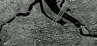
With actual SAR processing, about a thousand calculations are
performed for every single pixel. And an image like the one shown
above of Washington, D.C., is made up of several million pixels.


|
|
This SAR image of Washington, D.C., was taken on a snowy
night in 1994.
|
|
|

