
|

|

|
Extreme Science January 27, 1998 By Mark Hoover next If you're one of those people who leaves your seatbelt on for the whole flight from New York to Los Angeles, just in case there's turbulence, then you can especially appreciate the mix of fascination and...anticipation...that goes with waiting for the right storm to form way out in the central Pacific, a storm violent enough to attract meteorologists who want to fly through it and take its pulse. I'll be hitching a ride with those meteorologists, and you can bet I'll have my seat belt on.
In October, NOVA got started on a television program about
El Niño and the global weather machine, which will air
in the fall. As one of the people making the program, I
learned about meteorologists who, shall we say, really get
into their work. They fly specially equipped planes through
the core of violent Pacific storms to collect data that
cannot be gotten in any
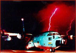
There will be only a day or two's notice before a candidate storm proves strong enough to be worth sending the planes out. With a crew of eight, including Navy pilots, navigators, and even a "bombardier," these are serious missions. More on that bombardier: the plane itself is bristling with instruments, weather radars, and fancy computers, but still, it's only one plane flying in a straight line through the storm. In order to add an extra dimension to the data gathered from the flight, drop sondes are jettisoned out a special chute every few minutes, once the action heats up. Fitted with propeller wings like a maple pod, these miniature weather stations radio back a stream of measurements as they spin down through the storm until splashing into the sea four or five miles below. At almost a thousand dollars a pop, you don't want to waste them on just any old storm. When the drop sondes' data is combined with the plane's, and correlated with satellite measurements and land-based radar images, a three-dimensional portrait of the storm emerges, a CAT scan of a killer still in its lair. So here I sit, waiting, watching the Weather Channel a lot more than usual, listening for the phone to ring, and a voice to say, "we're on!" Then I'll hurry to join the crew in the plane for a rendezvous with a monster. So will you, as we recreate the Storm Flight for you here on the Web site. El Niño has been throwing off a lot of Pacific storms this winter, but no one knows exactly when the next whopper will spin up. A storm that formed over the weekend almost had the right stuff, but started breaking up at the critical moment of decision. That's ok. There's plenty more where that came from. (next dispatch)(table of contents) Photo: USAF Anatomy of El Niño | Chasing El Niño | El Niño's Reach Dispatches | Resources | Mail | Site Map | El Niño Home Editor's Picks | Previous Sites | Join Us/E-mail | TV/Web Schedule About NOVA | Teachers | Site Map | Shop | Jobs | Search | To print PBS Online | NOVA Online | WGBH © | Updated November 2000 |
 other way. This is what I call extreme science. And it's
only the first of many adventures we'll embark on over the
next month as we take the measure of El Niño, from its
other way. This is what I call extreme science. And it's
only the first of many adventures we'll embark on over the
next month as we take the measure of El Niño, from its