
|

|

|
The Pineapple Express January 29, 1998 By Mark Hoover previous | next It's beginning to look like the predictions that the worst is yet to come for El Niño effects this year might be correct. The next couple of storms that are brewing up right now, out in the Pacific, look like textbook El 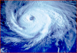 Niño cyclones, and the meteorologists are salivating.
I'm ready and waiting for the word from the storm fliers as
these storms spin up and head for shore.
Niño cyclones, and the meteorologists are salivating.
I'm ready and waiting for the word from the storm fliers as
these storms spin up and head for shore.This week, we are seeing the first signs of what meteorologists call a "regime change," or a shift in the patterns of the polar jetstream. It's this jetstream that conducts storms from the Pacific onto the west coast—the so-called stormtrack. The storm that surprised scientists yesterday demonstrates the change this stormtrack is undergoing. This morning, central and northern California are getting drenched, while the mountains inland are receiving several feet of snow. Last fall, scientists based their predictions of triple normal rainfall in California this winter on an expectation that a fork would develop in the polar jetstream—a classic El Niño pattern. The southern branch of this fork would then carry storms to California, rather than farther north. However, so far Oregon and Washington have already received roughly triple the normal January rain and snow this winter, because the jetstream hadn't forked yet, and all the storms stayed to the north. If the first signs of this southerly shift pan out, we'll see the so-called "Pineapple Express" fire up, and begin to dump on California what it's already been dumping on the northwest states. Like clockwork, every few days, warm, moist air between Hawaii and Alaska will react with cold polar air, form storms, and then be conducted by the south branch of the jetstream to California. Meanwhile, on the other side of the equator, Peru has been slammed and dunked by a furious series of El Niño-induced rainstorms for the past 72 hours. Early reports suggest that over 70 people have lost their lives, and 22,000 more are homeless, in the worst flooding of at least 50 years. The coastal regions of Ica in southern Peru, and Tumba and Piura in northern Peru, have been devastated by relentless rains and surging rivers, which have overrun their banks and gouged into the surrounding country. These coastal Peruvian regions are exactly where we will be filming the NOVA television show in a few weeks' time, and that only makes the disaster seem more immediate, and frankly, more frightening. previous dispatch | next dispatch | table of contents Photo: NASA Goddard Space Flight Center. Anatomy of El Niño | Chasing El Niño | El Niño's Reach Dispatches | Resources | Mail | Site Map | El Niño Home Editor's Picks | Previous Sites | Join Us/E-mail | TV/Web Schedule About NOVA | Teachers | Site Map | Shop | Jobs | Search | To print PBS Online | NOVA Online | WGBH © | Updated November 2000 |