
|

|

|
The Heart of a Storm February 2, 1998 By Mark Hoover previous | next I'm writing this dispatch from Carmel, California, and it's a race to see which goes belly-up first: my computer's battery, or me. Both of us have been up all night without a recharge on a remarkable journey through the heart of a powerful Pacific storm.
Shortly after returning to my hotel this afternoon, the
lights started dimming spasmodically, and then simply went
out—a casualty of the storm
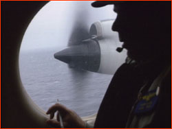
In an extraordinary piece of luck, the epicenter of the biggest storm yet this winter moved into position a few hundred miles from Monterey this weekend, and the meteorologists of CALJET (the project behind these flights) scrambled to make the most of their fortune. When I got the heads-up for the flight, takeoff was set for 10:00 pm, and was then moved to 2:00 am as the last position reports came in. The aircrew and scientists assembled at the aviation center here a little after midnight. Meanwhile, 100 miles south and north of us, ground-based stormwatchers sped to precise locations in DOWs, or Dopplers On Wheels, which look like trucks onto which a small flying saucer has crashed. Developed to track Oklahoma tornadoes, the DOWs provide a detailed radar image of the storm as it reaches the coast. Our mission was to intercept the storm near its center, and begin a series of profiling runs at different altitudes, back and forth across the "fronts," or boundaries, between warm and cold air. Dropsondes (tiny weather stations equipped with telemetry radio) dropped through a hatch would add the third dimension to the emerging picture of the intricate structures of moving air. Each transit of a front, particularly the passage from cold air to warm, promised a rough ride; how rough depended on the windspeeds of the channels of air-the scientists called them jets-that hurtle along in front of these boundaries. The plane was loaded for bear. With nine crewmembers, six scientists, 50,000 pounds of fuel...and me...we accelerated down the runway at Monterey airport at a quarter past two, and headed into a pitch black nigh. What we discovered surprised-even confounded-the scientists. For over nine hours we roamed vast corridors of wind and rain in a shuddering Orion P-3 airplane, taking measurements that could be gotten no other way. Join us on February 5 for StormFlight as we recreate this exciting, sometimes frightening, and extraordinarily insightful journey into the 100-mile-an-hour winds of a major Pacific storm. previous dispatch | next dispatch | table of contents Anatomy of El Niño | Chasing El Niño | El Niño's Reach Dispatches | Resources | Mail | Site Map | El Niño Home Editor's Picks | Previous Sites | Join Us/E-mail | TV/Web Schedule About NOVA | Teachers | Site Map | Shop | Jobs | Search | To print PBS Online | NOVA Online | WGBH © | Updated November 2000 |
 we had just plumbed. Not that I could feel any more
powerless after last night. Strapped in my orange flight
seat, and looking out the window at dawn, I now understood
why a note of reverie shaded the explanations given by the
meteorologists for these stormflights. I had thought that in
an age of robots and remote-control, there was no call for
scientists to put themselves in harm's way. Now I see there
is no substitute.
we had just plumbed. Not that I could feel any more
powerless after last night. Strapped in my orange flight
seat, and looking out the window at dawn, I now understood
why a note of reverie shaded the explanations given by the
meteorologists for these stormflights. I had thought that in
an age of robots and remote-control, there was no call for
scientists to put themselves in harm's way. Now I see there
is no substitute.