|
Ever since its sensational unveiling by Yale University scholars in October
1965, the Vinland Map has been a lightning rod for passionate debate. Most
reviews of the arguments, including NOVA's program, have focused on scientific
tests designed to gauge the authenticity of the map's ink. The opinions of
experts in cartography and historical manuscripts have commanded much less
attention, yet from the outset scholars in these disciplines pointed out
glaring anomalies in the case for the Vinland Map's authenticity. (To inspect the map,
see The Map in Question.)
Most striking of all, the coasts of Greenland and Iceland are suspiciously
close to their outlines in a modern atlas. Yet none of the Icelandic sagas
identifies Greenland as an island, and archeological discoveries indicate that
Viking colonists, hunters, and traders explored Greenland's west coast perhaps
as far north as Thule and Cape York, but no farther. Even a century or two
after the supposed date of the Vinland Map, European mapmakers were still
divided about how to draw Greenland—as an island, part of an arctic
landmass, or a peninsula dangling down from northern Europe. The precision of
the outlines of Greenland and Iceland is all the more surprising when compared
to the Vinland Map's depiction of the Viking homelands in Scandinavia, which
are barely recognizable: Sweden has migrated to the wrong side of the Baltic
while Norway has been flipped to match the map's overall egg-shaped design.
 Did the Vikings make maps?

Could the accuracy of the Vinland Map be testimony to the Vikings'
extraordinary seamanship and mapmaking skills? Did the alleged medieval author
of the map use an earlier Viking map as a source of information?
Unquestionably, the Vikings were the most audacious and accomplished voyagers
of the medieval world. Their sleek, clinker-built longships and bulkier cargo
boats had reached Iceland during the 9th century A.D. and Greenland during the
10th, leading to permanent colonies and regular trade with the Scandinavian
homelands. Beginning in 1961, the excavation of longhouses and typical Norse
artifacts at L'Anse aux Meadows in Newfoundland proved that Greenland settlers
had reached North America, just as the tales of Vinland in the Icelandic sagas
had always claimed.

Few historians seriously consider an argument based on missing evidence.

Such far-flung voyages of discovery demanded special navigation skills. An
Icelandic codex known as Hauksbok details signs such as the appearance
of whales, seabirds, and distant mountain peaks that voyagers would watch for
as they crossed the open ocean. Viking sailors may also have developed simple
astronomical aids, such as steering by the sun or the Pole Star, although there
is no firm evidence for these practices. But however accomplished their
seamanship, the Vikings never seem to have charted the coastlines they
explored. Despite the detailed navigational texts and abundant geographical
references in the sagas, no Norse cartographic drawing or engraving has
survived. They don't appear to have been mapmakers at all.
The colorful Icelandic tales of Leif Eriksson and his followers did inspire
European mapmakers to create North American charts identifying features
mentioned in the stories, such as Markland, Helluland, and Vinland. But this
interest in the sagas only took off during the 16th and 17th
centuries—long after the purported mid-15th-century date of the Vinland
Map. Beginning around 1570, Protestant mapmakers began incorporating new
knowledge of the Americas based on pioneering Portuguese and English voyages of
discovery. A strong motive for documenting the earlier Norse traditions of
settlement was to repudiate Catholic maps and territorial claims defined by
papal treaties. But even the most detailed of these maps, such as the Resen Map
of 1605, appears to have been mainly an exercise in fantasy.
Missing evidence
One prominent cartographer did vigorously defend the Vinland Map—R. A.
Skelton, superintendent of the British Museum's map room, who devoted seven
years to vindicating the map for Yale's 1965 publication. The map convinced
Skelton that news of Norse colonizing activities must have somehow reached
medieval European mapmakers and influenced their depiction of the world. To
explain why it was so unlike other medieval worldviews, Skelton was forced to
hypothesize the existence of an earlier missing chart, which had been poorly
copied by the author of the Vinland Map. But few historians seriously consider
an argument based on missing evidence.
Assuming the map is a fake, its perpetrator had several likely sources of
inspiration. The African and Asian continents resemble those on a pioneering
map drawn up in 1436 by a Venetian sailor, Andrea Bianco. Although the Bianco
Map portrays the world more realistically than previous medieval examples, it
shows no hint of Iceland, Greenland, or any major landmass west of the
British Isles.
The mystery island
For the depiction of Vinland, the forger apparently turned to two landmark
Portuguese maps, one largely copied from the other, dating to 1502-1505. The
celebrated Cantino and Canerio maps incorporate the discoveries of the
Corte-Real brothers, Portuguese explorers who made two voyages to Greenland and
Newfoundland in 1500 and 1501. The explorers claimed these lands for the
Portuguese crown and had no idea that the Norse had preceded them.
The map was a clever blending of influences, but not clever enough to cover up its false origin.
Canerio's map shows Portuguese flags planted on Greenland and on what
cartographers have come to refer to as the "mystery island," situated in the
mid-Atlantic. The inscription on the Canerio Map links the mystery island with
the Corte-Real brothers, and it may, in fact, represent Newfoundland, shifted
to the mid-Atlantic for political reasons. A papal treaty had established a
boundary line in the Atlantic to demarcate Spanish and Portuguese territorial
claims, so moving Newfoundland closer to Europe may have been intended to
strengthen the Portuguese claim on its discovery.
Whatever the explanation of the mystery island on the two Portuguese maps, its
roughly similar size and position as "Vinilanda Insula" on the Vinland Map is
an important clue. The Cantino and Canerio maps date to some 60 years after the
supposed date of the Vinland Map, adding to the evidence that the Vinland Map
is a fake. It seems that the forger turned to the mystery island as a model for
Vinland, while the Bianco Map helped fill in Asia and Africa.
None of the three old maps that seem to have inspired the Vinland forger were
widely known or available for study until the 20th century. Whenever the map
was concocted—and whoever did it—it was a clever blending of
influences, but like the ink recipe, not clever enough to cover up telltale
traces of its false origin.


| 
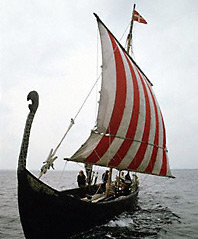
Ocean-faring vessels like this longship replica allowed the Norse to venture
far across the Atlantic and helped spawn the Viking Age.

| |
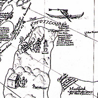
A map made in 1605 by Bishop Resen of Iceland used geographic names from the
Vinland Sagas to stake a claim to the New World. The map shown here is
an 1884 copy.
| |
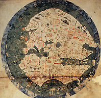
The Bianco Map of 1436, drawn near the time of the alleged creation of the Vinland Map, was likely used as a template by the Vinland Map's forger.
| |
|