 |
SATELLITE PHOTO ON JANUARY 19th
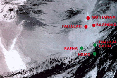
This infrared satellite photo taken on Jan. 19, 1991, by the National Oceanographic and Atmospheric Administration shows cloud formations and thermal activity over Iraq and northern Saudi Arabia. Jim Tuite, a former lead investigator for a Senate committee that inquired into Gulf War Syndrome, says the photo depicts thermal plumes rising from bombed Iraqi chemical weapons storage sites - including Muthanna and Fallujah - and gravitating southward toward the Saudi border locations of Hafir al Batin and King Khalid Military Installation. U.S. troops were bivouacked at several points throughout the Saudi border area. The CIA says the fallout from the aerial bombing did not make it that far south.
|


