|
|
|
 |
Posted: March 20,
2006 |
|
   |
|
|
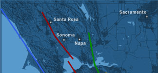
 Hayward-Rodgers Creek Fault Hayward-Rodgers Creek Fault |
|
|
|
|
|
Probability for one or more magnitude 6.7 or greater earthquakes from 2003 to 2032: 27 % |
|
|
|
|
|
The Hayward-Rodgers Creek Fault is considered the most active and dangerous of the bay area faults. The Hayward portion runs through Alameda, Contra Costa, Santa Clara, and Sonoma counties, and the Rodgers Creek Fault runs from San Pablo Bay to Santa Rosa, Calif. Because the combined fault traverses the most densely populated area of the San Francisco Bay area, a rupture could affect an estimated 6 million to 7 million people, according to the University of California at Berkeley's Seismology Lab.
Two major earthquakes of about a magnitude 7 have occurred along the Hayward portion of the fault, one in 1836 and another in 1868. Buildings and roads that straddle the fault have been slightly shifted over the years by the fault's tectonic creep -- the earth on either side of the fault moving in opposite directions at the rate of about 0.2 to 0.4 inches per year. |
|
|
|
|
|
|