|
U.S.
Geological Survey research geophysicist Jack Boatwright
became something of an historian while creating a "shake
map" showing the intensity of ground shaking from the
1906 Northern California earthquake.
 He
extracted as much seismic data as he could from the 1908
Lawson report, the most authoritative account of
the earthquake's damage, and then searched local newspaper
archives and even visited cemeteries to see how many tombstones
had toppled for clues as to how violently the earth shook. He
extracted as much seismic data as he could from the 1908
Lawson report, the most authoritative account of
the earthquake's damage, and then searched local newspaper
archives and even visited cemeteries to see how many tombstones
had toppled for clues as to how violently the earth shook.
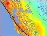
The
following images of the earthquake's damage and of the shake
map itself are from the U.S. Geological Survey.
RealAudio:
Boatwright describes some of the ways he collected the seismic
information. (2:06)
USGS
Northern California resources: More information
on the 1906 quake, including shake maps and hazard protections
|