|
Scientists
are hoping that an observatory they are working to submerge in
one of the world's most active faults -- California's San Andreas
Fault -- will help yield answers to the causes of earthquakes
and other questions that have perplexed them for decades.
The
San Andreas Fault, which skirts the western edge of California,
marks the boundary between the Pacific Plate on the west and the
North American Plate on the east. As the two plates grind against
each other, they create earthquakes.
In
an effort to learn how to predict earthquakes, or if predicting
them is even possible, U.S. Geological Survey and other scientists
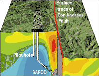
are working to plant an observatory 2.4 miles deep into a repeating
earthquake 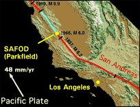 area
of the fault near the tiny town of Parkfield in central California. area
of the fault near the tiny town of Parkfield in central California.
Parkfield
has experienced a number of moderate earthquakes at a magnitude
of about 6 at fairly regular intervals -- 1857, 1881, 1901, 1922,
1934 and 1966. Scientists estimated that the next one would occur
between 1988 to 1993, but it is overdue.
A
magnitude 6.0 earthquake struck near Parkfield on Sept. 28, 2004,
which scientists believe may have reduced the stress at the part
of the fault where they are building the San
Andreas Fault Observatory at Depth. Once finished, SAFOD will
enable them to get real-time measurements of changes in temperature,
rock deformation and fluid pressure that precede an earthquake.
Through
the readings, scientists hope to learn more about the connection
between fluid pressure and quakes, said Steve Hickman, senior
research scientist with the U.S. Geological Survey and co-principal
investigator of SAFOD. When the fault heats up, fluid -- mostly
water -- swells and could be instrumental in triggering an earthquake
or controlling the size of the earthquake, he said.
By
observing the behavior of fluids, scientists may be able to recognize
a pattern when an earthquake is about to occur. Such short-term
earthquake prediction is the "Holy Grail" of geophysicists,
said Hickman. At this point, "most scientists don't even
know if [earthquake prediction] is possible," he added.
SAFOD
also will enable scientists to retrieve samples of subsurface
rocks and fluids for laboratory analysis.
A
pilot hole was drilled in the summer of 2002 about a mile from
the fault line to help guide construction of the main hole, which
used the oil industry technique of directional or diagonal drilling.
And in December 2005, project participants announced they had
reached a milestone in the project -- drilling across the San
Andreas Fault. They plan to start deploying instruments in January
and taking core samples of the fault in the summer of 2007.
 SAFOD
is one component of the National Science Foundation's five-year
$219 million EarthScope project, which is intended to help scientists
observe and learn more about the changes in the North American
continent and why earthquakes and volcanic eruptions occur.
SAFOD
is one component of the National Science Foundation's five-year
$219 million EarthScope project, which is intended to help scientists
observe and learn more about the changes in the North American
continent and why earthquakes and volcanic eruptions occur.
Also
under EarthScope is a project called the United States Seismic
Array, which will create a grid of semi-portable seismometers
to produce a high-resolution image of the Earth's crust and underlying
mantle to help link structures from earlier continental formation
with potential geologic hazards, according to NSF, which also
funds the NewsHour's Science Unit.
The
Plate Boundary Observatory will employ a network of Global Positioning
System receivers and strainmeters covering the western United
States and Alaska to record even the smallest movement across
faults.
And
the Interferometric Synthetic Aperture Radar, with the participation
of the National Aeronautics and Space Administration, will use
a satellite to detect changes in the Earth's surface before, during
and after major earthquakes and volcanic eruptions.
EarthScope
is intended to incorporate information across the Earth sciences
and the Earth science community, including members of USGS, NSF,
NASA, the Department of Energy, regional seismic networks, state
geological surveys and 100 universities.
--
By Larisa Epatko, Online NewsHour
|