|

|

|
Goodbye El Niño, Hello La Niña
by Mark Hoover
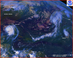
The numbers are in. A recently-released NOAA review confirms
that the latest incarnation of El Niño was, indeed, the
weather event of the century. Compared with the previous
title-holder in 1982, the 1997 El Niño started earlier,
grew faster, and amassed more energy. And then, in the
parlance of the researchers who study it, "it got legs,"
maintaining its prodigious dimensions for months longer than
in 1982.
|
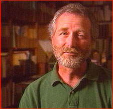 Mike McPhaden
|
Not content to just fade away, the El Niño in its
endgame rewrote the record books again, as it receded at an
unprecedented rate. El Niño's sea-surface temperature
anomaly "just dropped like a rock. It was a hell of a signal,"
says Mike McPhaden, who directs NOAA's tropical Pacific
monitoring program from his laboratory in Seattle. "We've
never seen anything like it." He should know. Using one of the
largest scientific instruments ever built—the Tropical
Atmosphere/Ocean Array,
a network of buoy-mounted monitors
stretching across the Pacific from Peru to
Australia—it's his job to watch for changes in that
swath of the Pacific that is the womb of Earth's weather.
But now, finally, El Niño is gone, and as winter
approaches, people around the world can breathe a collective
sigh of relief...right? Unfortunately not.
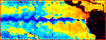 Pool of cold water (blue) off coast of South America.
|
|
True, the giant pool of abnormally warm water in the tropical
Pacific that made last year's weather so difficult has gone
away. But in its place, an abnormally cold pool of water has
appeared, and it seems to have its own mischievous agenda. The
hot and cold extremes are both avatars of the El Niño
phenomenon, more properly called ENSO, or
El Niño-Southern Oscillation,
a name that reflects its dual nature.
El Niño's dramatic turnabout may portend yet another
year of devastating weather ahead. As El Niño has
transformed itself with lightning speed into its own opposite,
the past year's weather disruptions may have been queued up to
be played again, but with a twist; what was baked will be
frozen, what was drenched will be parched, what was spared
will be slammed. This "cold phase" sometimes brings weather
that is the mirror image of El Niño.
It's not a perfect symmetry, points out Michael Glantz, of
NOAA's National Climate and Atmospheric Research center in
Boulder, Colorado. The mechanics of El Niño's cold
cycle are fundamentally different from the warm cycle. "The
rule of thumb is that the cold events don't get as cold as the
warm events get warm. If you heat the ocean, you get lots of
rain, way above normal. But if you cool the ocean, the most
that happens is you shut off the rain. Once it's shut off, you
can't get negative rain."
Still, even Glantz thinks this year may be exceptional. "The
other shoe may be about to fall," he says. "Together, a strong
El Niño and a strong La Niña can pack a
climatological one-two punch second only to the change of
seasons as a shaper of Earth's weather." Warning signs are
already abundant. Consider the following:
-
During a May and June that seemed more like August, much
of the US sizzled for weeks in temperatures 10, 20, even
30 degrees above normal.
-
The Southern plains and the Southeast broiled all summer
long under record heat. Texas and New Mexico in particular
were hit by relentless strings of plus-90 and plus-100
degree days throughout June, July, and well into August.
Rain was sparse, and crop losses quickly mounted.
-
Florida, wracked earlier in the spring by a rash of
tornadoes, was next blackened by fires consuming its
dried-out forests and grasslands as the rains failed in
early summer. Although the rains finally returned, so did
the threat of a hyperactive hurricane season.
-
The Atlantic hurricane season got off to an early start,
and changes in upper-level winds over the Atlantic have
made conditions ideal for hurricane formation. NOAA's
Mississippi-based Hurricane Hunter storm fliers have
stayed on alert as the warm waters off the African coast
have generated tropical depressions like clockwork every
three or four days.
-
The year of torrential El Niño rain along the
Pacific coast of South America ended in late spring.
Taking its place is the haunting specter of a year of
drought. It may easily be a full year before a single drop
of rain falls in parts of coastal Chile.
-
In June, fires burning out of control in drought-stricken
central Mexico created massive clouds of acrid smoke,
easily visible from space. Part of the burned area was a
critically important biodiversity reserve, a last stand
for numerous endangered species. Each day of fire brought
extinctions. Then, like a flipped switch, torrential rains
came late in the summer, and brought a new nightmare:
flooding. The burnt land was further scarred by erosion,
without plants to soak up the water. Many people died as
rivers left their banks and inundated surrounding
lands.
|
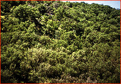 Chaparral
|
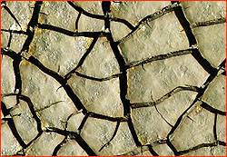
-
California may face a fire peril of its own. El
Niño rains stimulated lush growths of desert brush
(called chaparral) on coastal mountainsides. Now, La
Niña threatens a desiccating drought that will turn
the overgrowth into a tinderbox by late autumn.
Uncontrollable fires are possible, perhaps likely. There's
more: chaparral ash leaves behind a waxy film on the soil,
which will prevent winter rains from soaking in, resulting
in flash floods.
So when can when we expect the tropical Pacific to return to
normal? The surprising answer is basically, never. Normal is
an average, but averages don't tell us much about actual
conditions. If you stand with your feet frozen in a block of
ice and your head in a pizza oven, your "average" body
temperature might be 98 degrees, but you will be not survive.
Likewise, although we know that year-in, year-out, the
tropical Pacific on average is neither overly warm nor overly
cold, there are very few times when, like Goldilocks'
porridge, it's "just right." Most of the time, tropical ocean
temperatures and currents are see-sawing in slow motion toward
one extreme or the other, in a natural and recurrent cycle
that takes years to complete. "We have to stop thinking of El
Niño as an event, and start thinking of it as part of
the Earth's breathing," says Princeton's George Philander.
"It's as natural for the Earth to have El Niño as it is
for a bell to ring." In a word, it's normal for the ocean to
be abnormal.
Just as morning gives way to afternoon, then to night, then to
morning once again, El Niño always gives way to the
next part of its cycle—and so sets up the conditions for
its eventual return. In 1985, Philander coined a name for this
"next part" of El Niño, calling it La Niña, or
"Little Girl" to go with El Niño's "Little Boy." The
name stuck.
The La Niña half of the phenomenon is even less
understood than the El Niño half, in part because
something has suppressed La Niña formation for the past
20 years—precisely during the time instruments capable
of monitoring it were developed and deployed. Scientists want
to find out what that "something" is, especially because that
"something" seems to be loosening its hold, indicating
long-term changes in the climate system. Some think global
warming may involved; some think a larger oscillation
involving the entire ocean is to blame. No one can say yet.
Whether it's a boom or bust, one thing can be said with
certainty about the upcoming La Niña; it's going to
crush a lot of cherished theories. With a dozen or more
computer models predicting everything from Armageddon to a
no-show, "its time for natural selection to do a little
weeding of our theories" says McPhaden. As happened with the
models that tried to foresee El Niño, there will be
some predictions right on the money, and some just plain
wrong.
See
El Niño Scorecard
to find out how the predictions stacked up to reality.
Photos/Illustrations: (1) NOVA/WGBH; (2,3) NOAA; (4,5)
©Dr. John D. Cunningham/Visuals Unlimited.
Anatomy of El Niño
| Chasing El Niño |
El Niño's Reach
Dispatches |
Resources |
Mail |
Site Map |
El Niño Home
Editor's Picks
|
Previous Sites
|
Join Us/E-mail
|
TV/Web Schedule
About NOVA |
Teachers |
Site Map |
Shop |
Jobs |
Search |
To print
PBS Online |
NOVA Online |
WGBH
©
| Updated November 2000
|
|
|