
|

|

|
California Gets Hit March 4, 1998 By Mark Hoover previous | next 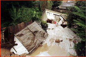 I finally got on a jetstream flight. Kinda. But first, after
six intensive weeks of being on the road, tracking El
Niño with some of the brightest oceanographers and
meteorologists on the planet, it's time to add a few things
up.
I finally got on a jetstream flight. Kinda. But first, after
six intensive weeks of being on the road, tracking El
Niño with some of the brightest oceanographers and
meteorologists on the planet, it's time to add a few things
up.Okay, I can add up the frequent flyer miles later (did anyone say Paris?) Actually, if I don't eat another pack of sky peanuts for a long while, that's fine by me. I did the red-eye thing one last time over the past few days, and got home yesterday from a whirlwind tour (note the carefully chosen phrase) of California. Why California? As any Californian would tell you, for CLOSURE, man, closure. El Niño spent six months beating up the rest of the world. Catastrophic forest fires and rivers without water in Indonesia. Killing torrential rains, tidal surges, and typhoons in southern China. The worst floods in history in Peru. The strongest pacific hurricane ever measured along the Mexican coast. Drought and starvation in parts of southern Africa. The list goes on. But because in January, California—which has about one five-hundredth of the world's land area—hadn't yet gotten hit, El Niño was being called El No-show, El Yawño, and whatever else the Letterman and Leno staff writers could turn into a pun. The rest of the Earth could disappear in a planetary hurricane, but if California didn't get hit, the conventional wisdom seemed to be that El Niño was a bust. 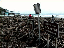 February, of course changed all that, and the storms and rain
of the past 10 days were the worst yet. Suddenly it's clear
the California climate prediction gurus who went way out on a
limb last summer predicting double or even triple normal rain,
destructive surf, mudslides, flash floods...were right on the
money; eight weeks ago they were nervously wondering if they
should update their resumes. Despite all the hardships brought
to California recently by El Niño, there's little
mention of all the trouble avoided by the excellent
advance warning
our detection systems and prediction models provided this
year. Up and down the pacific coast, emergency teams drilled,
cities cleaned out spillways and flood channels, and citizens
patched up substandard buildings and laid in supplies. If we
have power against the weather, it lies in our understanding
of what to expect.
February, of course changed all that, and the storms and rain
of the past 10 days were the worst yet. Suddenly it's clear
the California climate prediction gurus who went way out on a
limb last summer predicting double or even triple normal rain,
destructive surf, mudslides, flash floods...were right on the
money; eight weeks ago they were nervously wondering if they
should update their resumes. Despite all the hardships brought
to California recently by El Niño, there's little
mention of all the trouble avoided by the excellent
advance warning
our detection systems and prediction models provided this
year. Up and down the pacific coast, emergency teams drilled,
cities cleaned out spillways and flood channels, and citizens
patched up substandard buildings and laid in supplies. If we
have power against the weather, it lies in our understanding
of what to expect.Los Angeles had its first real weather break in a month this weekend, and I arrived in beautiful weather. However, two ominous storm systems are gathering at this moment out in the Pacific, and on the satellite photos I'm looking at, the second one already shows signs of a "pineapple tail" dipping south like a straw to suck El Niño heat and moisture north and east. There is a lot more rain in the West Coast's near future. Also, bear in mind that March is traditionally the rainiest month along the West Coast, anyway. I drove my rented car around Los Angeles Saturday, making my way to the Pacific Coastal Highway that leads to Pacific Palisades, Topanga, and Malibu. Despite the sunny weather, evidence of the recent havoc was all around. Particularly near Malibu, the hillsides were sodden and threatening to collapse; scores of smaller collapses had already created diversions and road hazards. Some hillside houses had been abandoned. Sinkholes had opened, including one right in Century City, a heavily urban area dominated by television and movie industry high-rises. Along the sea, some beach houses were wrecked, and many more were boarded or fortified. Where they hadn't been washed away, the hillsides were incredibly green, as in the Galapagos, a green I've not seen before in the Mediterranean climate that prevails in Los Angeles. On Sunday, I drove down to San Diego along the Santa Ana Freeway, which hugs the coast for most of the two-hour drive, on my way to the Scripps Oceanographic Institute, where some of the best El Niño modelers and predictors work in Scripps' Experimental Climate Prediction Center. One upshot: later this week we'll give an ECPC scientist a chance to say, "I told you so," and more importantly, a chance to say what's still in store.  Again I was struck by evidence, especially along the
beachfronts, of the recent violence. I had hoped to get a
close-up look at the Scripps Coastal Data Information
Program's radical new regional wave forecaster, but guess
what: El Niño had taken out its data platform, in its
offshore location.
Again I was struck by evidence, especially along the
beachfronts, of the recent violence. I had hoped to get a
close-up look at the Scripps Coastal Data Information
Program's radical new regional wave forecaster, but guess
what: El Niño had taken out its data platform, in its
offshore location. Later on, I took a shuttle flight up to San Francisco, which if anything has been hit harder than southern California. A deck of clouds moved in and blocked the late afternoon sun, but didn't prevent me from seeing evidence that the Bay Area has gotten about 125% of the rain it can safely absorb. I had hoped to get to Pacifica, about 10 or 15 miles south of San Francisco on the coast, to observe firsthand the hillsides that were melting away, carrying quantities of mud, asphalt, and broken houses down into the sea. Alas, the plane of the scientist I was supposed to join up with for the short drive was cancelled, and we never got the chance. I can assure you, however, that it doesn't take an expert to recognize the signs of extreme weather duress, and it was painful to drive around San Francisco and see the transformations wrought by El Niño. About that jet stream flight. During a fit of temporary insanity I had purchased an overnight flight ticket back east. An airline whose name I will withhold wedged me into a seat that reminded me of when I was six, and forced to sit in a booster chair at Howard Johnson's on fried clam night: a middle seat, in a row whose window looked out at the side of the jet engine bolted to the fuselage; a seat between two persons of hearty girth, one of whom snored like Curly the Stooge. The captain's voice came on the intercom as we accelerated out of San Francisco International, and he casually announced that to take advantage of an unusually strong jetstream, the plane would fly at 37,000 feet, and arrive at the gate in Chicago 30 minutes early. And then he turned the lights out. As the plane surfed along in the jetstream at three in the morning, and I breathed the peanut fumes coming from the row in front of me, I drew my arms as close together as possible to avoid disturbing Curly on my right and Orson Welles on my left. My thoughts ran to that other jetstream flight I was supposed to take, the one in Hawaii, in the sleek NOAA Gulf Stream jet out over the Pacific, probably sipping on pineapple juice and munching macadamia nuts, and upon landing, donning a lei or something, and I thought...well, you know what I thought...El Niño got me again. :) So what's next? A lot of visitors to this Web site have written asking what will happen later this summer, and even next winter. So we have invited two scientists to help give us a look ahead, as the next two dispatches shift from the present to the future. How much longer will El Niño last? Will the summer be hot and dry? Will next winter be cold and harsh? Will La Niña displace El Niño? If you're interested in the answers to these questions, don't miss the rest of this week's dispatches. previous dispatch | next dispatch | table of contents Photos: (1) Reuters/Lou Dematteis/Archive Photos; (2) California Governor's Office of Emergency Services/Robert A. Eplett. Anatomy of El Niño | Chasing El Niño | El Niño's Reach Dispatches | Resources | Mail | Site Map | El Niño Home Editor's Picks | Previous Sites | Join Us/E-mail | TV/Web Schedule About NOVA | Teachers | Site Map | Shop | Jobs | Search | To print PBS Online | NOVA Online | WGBH © | Updated November 2000 |