
|
 |
 |
The Way to the Summit Western CWM | Lhotse Face | Yellow Band | Geneva Spur South Col | Southeast Ridge | South Summit | Cornice Traverse Hillary Step | Summit  The Western Cwm
See Western Cwm QTVR Often called the "Valley of Silence," the Western Cwm is a broad, flat, gently undulating glacial valley basin terminating at the foot of the Lhotse Face. The central section is cut by massive lateral crevasses which bar entrance into the upper Western Cwm. In this section, climbers must cross to the far right, over to the base of Nuptse to a narrow passageway known as the Nuptse corner. From here, climbers have a stupendous view of the upper 8,000 feet of Everest—the first glimpse of Everest's upper slopes since arriving at Base Camp. The last 5,000 feet on Everest, including its distinct black pyramid summit, are not visible from Base Camp. Contrary to what most people believe, some of the most difficult days on Everest are in the Western Cwm, when on a windless day it is desperately hot. Says David Breashears, "You literally pray for a puff of wind or a cloud to cover the sun so you can keep moving up to Advance Base Camp." 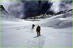 The Lhotse Face
See Camp III QTVR The expansive western flank of Lhotse is called the Lhotse Face and is an unavoidable part of the traditional southeast route up Everest. Camp III sits about halfway up this ascending wall of glacial blue ice. From its bergshrund (base) to the top, the Lhotse Face rises some 3,700 feet, at 40 and 50-degree pitches with some occasional 80-degree bulges. The entire route is fixed with ropes, and climbers must get into the rhythmic movement of pulling and stepping up. Kicking steps, while lodging one's front points into the hard blue ice, is the predominant movement required for this unrelenting ascent up towards the South Col. The Yellow Band The sedimentary sandstone rock of the Yellow Band is a distinctive feature of the Lhotse Face which requires about 100 meters of rope to traverse it. This is the first rock a climber touches on the route up Everest. It becomes very obvious when one has reached this point in the climb—one's crampons hit hard rock. The top of the yellow band is at 25,000 feet. 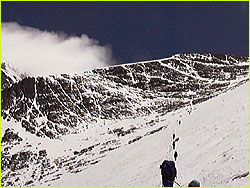 The Geneva Spur
Named by a Swiss expedition in 1952, the Geneva Spur is an anvil-shaped black rib of rock fixed with ropes so climbers can scramble up its steep snow-covered surface. The spur starts at about 24,000 feet. It is the last major hurdle before reaching the last camp on Everest. The South Col The site of the high camp, also known as Camp IV, this rock-strewn wind-swept saddle between Everest and Lhotse lies at 26,000 feet. Col is a Welsh word for saddle or pass. This location was named by the British Reconnaissance Expedition of 1921 which viewed it from a vantage point some seven miles away. Currently used by all expeditions as the high camp, it is still a demanding 3000-foot climb from here to the summit. Discarded expedition equipment litters the football field-sized area used for camp. At this elevation, all expedition and Sherpa members sleep with a low flow of oxygen except those wishing to attempt the summit "gas free." Fierce jet stream winds can demolish an uninhabited tent here in minutes so the expeditions do not erect their tents until they arrive. The Southeast Ridge The climbers reach the Southeast Ridge at 27,700 feet at a place known as "The Balcony." At this platform the climbers rest and admire the dawn light illuminating the peaks to the east and south. From here, the snow ridge rises 1,000 feet to the South Summit and gently arcs to the north. 400 feet below the South Summit, a series of rock steps often forces climbers to the east and into waist deep snow. This can often be the most strenuous and dangerous section of the climb, because the wind-deposited snow can be avalanche prone. The South Summit The climbers' first small victory of the day, the South Summit is a ping pong table-size dome of snow and ice at 28,700 feet. From here the climbers can obtain the view of the final obstacles ahead of them: the Cornice Traverse, the Hillary Step, and the final slopes to the summit. It is traditional to change oxygen bottles here so that one has a fresh bottle for the final ascent and return to the South Summit. If it's late in the day or the weather is deteriorating, this is the place to make the all-important decision to turn around. The Cornice Traverse A 400-foot long horizontal section of rock and wind-carved snow, this is easily the most intimidating section of the climb. Climbers must carefully traverse a knife-edge ridge of snow plastered to intermittent rocks. This is the most exposed section of the entire climb, and a misstep to the right would send a climber tumbling down the 10,000-foot Kangshung Face. A misstep to the left would send one careening 8,000 feet down the Southwest Face, were it not for the fixed ropes. The Hillary Step The most famous physical feature on Everest, the Hillary Step, at 28,750 feet, is a 40-foot spur of snow and ice. First climbed in 1953 by Edmund Hillary and Tenzing Norgay, the Hillary Step is the last obstacle barring access to the gently angled summit slopes. Modern-day climbers use a fixed rope up here to ascend the Hillary Step. We marvel at Hillary and Tenzing's achievement in climbing this impressive mountaineering obstacle without fixed ropes and using what is now considered primitive ice climbing equipment. The Summit See QTVR View from the Summit At 29,028 feet, the world's highest point is covered with an assortment of prayer flags, remnants of surveying equipment and other offerings from climbers (photographs of family members, prayer packets, and discarded oxygen bottles). Covering the area of a picnic table, the snow-covered summit slopes steeply away to the north, southwest, and east. Climbers take care to not venture too far to the east as the massive cornices overhang a 10,000-foot face. The 360-degree panorama takes in the Tibetan Plateau to the north, as well as the great Himalayan peaks of Kanchenjunga to the east, Makalu to the southeast, and Cho Oyu to the west. On a clear day, it seems as if one can see across half a continent. 150 feet below the summit, climbers heading down often collect small rocks as mementos of their climb. Photos: (1) David Breashears; (2,3) Pete Athans Lost on Everest | High Exposure | Climb | History & Culture | Earth, Wind, & Ice E-mail | Previous Expeditions | Resources | Site Map | Everest Home Editor's Picks | Previous Sites | Join Us/E-mail | TV/Web Schedule About NOVA | Teachers | Site Map | Shop | Jobs | Search | To print PBS Online | NOVA Online | WGBH © | Updated November 2000 |