
|

|

|
Escape through Time
Fire |
Car |
Plane |
Ship

Jet engine
One of the most important developments in the long-term
improvements in aviation safety was the jet engine. Between
1946 and 1958, the United States averaged three major plane
accidents and 42 fatalities a year in accidents caused
primarily by engine failures. Since the introduction of the
passenger jet in the late 1950s, the number of crashes due to
engine failure plummeted, as did the total number of plane
accidents.
|
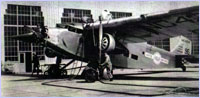 While traditional piston engines improved greatly
through the 1930s and '40s, they did not offer
satisfactory reliability.
While traditional piston engines improved greatly
through the 1930s and '40s, they did not offer
satisfactory reliability.
|
While traditional piston engines improved greatly through the
1930s and '40s, they did not offer satisfactory reliability.
In fact, as power increased (an objective in developing
military planes), reliable endurance tended to decrease. By
the 1950s, the best piston engines available could only run
1,500 to 2,000 hours before they required overhauls.
All this changed with the jet engine. In 1958, National
Airlines launched its jet service between New York and Miami.
These early jet engines extended the "time between overhaul"
(TBO) to 6,200 hours and then to 20,000 hours. Today, with
proper maintenance, jet engines can perform up to 50,000 hours
before a complete overhaul is needed.
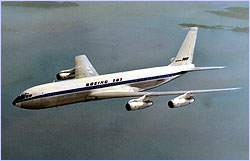 The Boeing 707, the first commercially successful jet
engine-powered plane, marked a new era of safer, more
powerful airplanes.
The Boeing 707, the first commercially successful jet
engine-powered plane, marked a new era of safer, more
powerful airplanes.
|
|
The increased performance level of jet engines affects safety
in a number of ways. Most obviously, the reliability of jet
engines ensures that crashes due to engine failure are
uncommon events. Jet engines also allow planes to fly longer
and faster, enabling planes to travel to a different airport
if their original destination proves unsafe for landing.
Finally, powerful jet engines allow planes to fly above
dangerous storms and turbulence.
back to top
Flight Recorder
The Flight Data Recorder is a powerful tool for avoiding plane
accidents. This instrument provides investigators with
information necessary to determine the cause of an accident.
It also educates aircraft engineers striving to build planes
whose improved design ensures that similar accidents will not
happen.
|
 Early flight recorders recorded time, air speed,
altitude, vertical acceleration, and heading on
metallic foil.
Early flight recorders recorded time, air speed,
altitude, vertical acceleration, and heading on
metallic foil.
|
In 1957, the U.S. Civil Aeronautics Board adopted a rule
requiring an approved Flight Data Recorder (FDR) aboard air
carriers and commercial airplanes over 12,500 pounds. These
early FDRs recorded time, air speed, altitude, vertical
acceleration, and heading. Styluses inscribed this informaion
graphically on a moving roll of metallic foil.
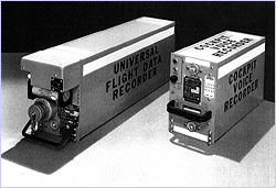
 Today's flight recorders can keep track of more than
700 parameters, which are stored on computer chips.
Today's flight recorders can keep track of more than
700 parameters, which are stored on computer chips.
|
|
Later, magnetic tape replaced foil recorded more detailed
information. With improved technology, more detailed
information was provided by FDRs. Today, the most advanced
recorders use digital solid-state devices that store flight
information on computer chips. These more reliable and
crash-worthy FDRs are capable of keeping track of more than
700 parameters, including pitch, roll, and control column
position.
How does one go about finding the FDR, or "black box," after
an accident? For one thing, the FDR is not black at all, but
rather bright orange, and it's covered in reflective material,
making it easier to locate. In addition, a sonar pinger is
attached to each recorder. These pingers have their own
batteries and are activated by water. Once initiated, the box
will emit a sound every second for 30 days.
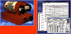
In order to ensure that the FDR survives the crash, it
undergoes a series of tests. Shot from a pneumatic cannon at a
solid barrier, the storage media must be able to withstand an
impact of 3,400 G's. (G's measure the force exerted by gravity
on a body as it is accelerating.) Penetration resistance is
tested by pounding a quarter-inch-diameter hardened steel rod
with a force of 500 pounds at the recorder's weakest point.
Flames of 2,000°F engulf the FDR, which also must be
capable of surviving for 30 days under 20,000 feet of
saltwater.
back to top
Ground Proximity
Flying in clouds or in darkness poses some major risks, the
most basic of which is inadvertently flying into the ground.
While the plane may be in complete control, loss of visibility
may result in a severe accident with mountainous terrain or
flat ground other than the intended landing site. These
crashes, called "controlled flight into terrain" (CFIT), were
major problems until one piece of technology presented an
extremely effective solution.
|
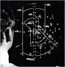 Early Ground Proximity Warning System displays
offered basic but vital information, which enabled
pilots to avoid controlled flight in terrain, once a
devastating problem in commercial flight.
Early Ground Proximity Warning System displays
offered basic but vital information, which enabled
pilots to avoid controlled flight in terrain, once a
devastating problem in commercial flight.
|
Ground Proximity Warning System (GPWS) monitors the aircraft's
height above ground as determined by a radio altimeter. A
computer then keeps track of these readings, calculates
trends, and can predict trouble ahead. An audible warning is
given if there is any possibility of danger. If the plane is
descending at too steep an angle during descent, is descending
too rapidly, has insufficient terrain clearance, or is flying
towards higher terrain, the pilot is given a warning to make
adjustments immediately. Since the U.S. Federal Aviation
Administration (FAA) required large airplanes to carry such
equipment in 1974, the number of accidents due to CFIT has
dropped from 7-18 a year to 1-2 a year.
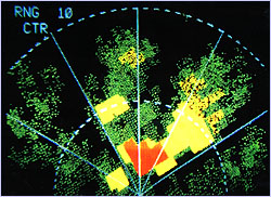 Today's Enhanced Ground Proximity Warning Systems can
accurately predict potential dangers using the Global
Positioning System. These detailed displays indicate
the contours of approaching terrain and designate
their proximity to the airplane's altitude with
colors.
Today's Enhanced Ground Proximity Warning Systems can
accurately predict potential dangers using the Global
Positioning System. These detailed displays indicate
the contours of approaching terrain and designate
their proximity to the airplane's altitude with
colors.
|
|
Traditional GPWS does have a blind spot. Since it can only
gather data from directly below the aircraft, it must predict
future terrain features. If there is a dramatic change in
terrain, such as a steep slope, the GPWS will recognize the
trend only very near the dangerous terrain. A new piece of
technology, the Enhanced Ground Proximity Warning System
solves this problem by combining a worldwide digital terrain
database with a Global Positioning System. With these tools,
the plane can pinpoint its position and compare it with a
stored map of all of the contours of the Earth's surface. The
pilot can easily observe the contours of the surrounding
terrain, and a warning system can give an early warning signal
when any features ahead may pose a collision threat.
back to top
Collision Avoidance
As airplanes began to fill the sky, mid-air collisions became
a real threat. In 1976, public concern over these accidents
lead to the Separation Assurance Program, which, among other
things, called for the development of the Beacon Collision
Avoidance System (BCAS). The search for such a device was not
new. As early as 1955, the Air Transport Association had been
working to develop this equipment; the FAA joined the search
in 1959. By 1976, the FAA had implemented a conflict alert
system, capable of warning air traffic controllers of
less-than-standard separation at all 20 air-route traffic
control centers in the U.S.
|
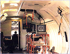 The FAA tests the Boeing 727 and its Traffic Alert
and Collision Avoidance System (TCAS) equipment.
The FAA tests the Boeing 727 and its Traffic Alert
and Collision Avoidance System (TCAS) equipment.
|
In 1981, an important improvement was made to the BCAS system,
which was unable to function in areas of extreme air traffic.
The FAA adopted Traffic Alert and Collision Avoidance Systems
I and II (TCAS I and II). Combining radio transmitters and
receivers, directional antennas, and computer and cockpit
displays, these TCASs transmit a radio signal called an
interrogation. Other airplanes in the area receive these
signals and transmit replies. Finally, computers calculate the
distance between the planes based on time between the
interrogation and the reply.
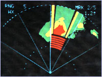
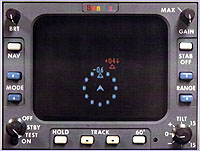 This Traffic Alert and Collision Avoidance System II
Display indicates traffic dead ahead 600 feet below
and another aircraft coming at 400 feet above. The
pilot will get an advisory to climb or descend if the
TCAS computer calculates that a collision hazard
exists.
This Traffic Alert and Collision Avoidance System II
Display indicates traffic dead ahead 600 feet below
and another aircraft coming at 400 feet above. The
pilot will get an advisory to climb or descend if the
TCAS computer calculates that a collision hazard
exists.
|
|
TCAS I systems provide pilots with the altitude and the
"o'clock" position of nearby planes. The high end TCAS II
system provides more sophisticated advisories, including data
on the range and bearing of nearby planes. These systems can
even suggest escape maneuvers. In 1989, the FAA required TCAS
II on all airlines with over 30 passenger seats operating in
U.S. airspace. Planes with 10 to 30 seats were required to
install TCAS I.
back to top
Wind Shear
|
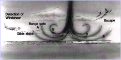 A microburst descends from a storm and sends strong
surface winds outwards, creating a dangerous situation
for planes that are landing or taking off.
A microburst descends from a storm and sends strong
surface winds outwards, creating a dangerous situation
for planes that are landing or taking off.
|
Wind shear poses one of the most dangerous threats to
low-flying airplanes. Downward "microbursts" of wind originate
from thunderstorm activity and fall to the Earth. Upon contact
with the ground, this dense burst of air radiates outwards,
generating dangerously strong surface winds. Approaching wind
shear conditions, the pilot would experience headwinds
followed by equally strong tailwinds. The combination of these
two forces can dramatically reduce air speed (the airplane's
speed relative to the surrounding air) and rob the wings of
their lift, resulting in a crash.
The first approach to combating this problem was a Low Level
Wind Shear Alert System (LLWAS) that became operational at
major airports in 1978. This system detected severe downdrafts
and wind changes with wind speed and direction sensors around
the airport periphery. When a microburst was detected, an
alarm sounded in the control tower, and pilots in the area
were informed.
By 1988, the FAA issued a rule that went a step further: All
turbine-powered airliners seating 30 passengers or more must
carry equipment that both warns pilots when they encounter
low-altitude wind shear and provides them with information to
escape safely. At first, these systems were reactive:
Detecting sudden changes in airspeed due to horizontal wind,
an alarm informed the pilot that they were flying in wind
shear conditions. The pilot was then able to react properly
and avoid stalling.
 New, forward-looking wind shear detectors make
visually clear to pilots hazardous wind shear
conditions ahead.
New, forward-looking wind shear detectors make
visually clear to pilots hazardous wind shear
conditions ahead.
|
|
New forward-looking detectors use radar to predict upcoming
weather events, including wind shear. The system bounces
energy pulses off the rain droplets or moisture of the
upcoming region and analyzes the distance to a potential
problem area by measuring the time it takes the pulse to
return to the aircraft. This radar can even detect which way
the air is moving by analyzing the way that the pulse was
reflected back: If it bounces off downward-moving particles, a
higher frequency is returned than if it bounces off particles
moving horizontally. These new forward-looking wind shear
detectors can give pilots as much as 90 seconds warning before
entering a wind shear system, giving them time to make the
necessary adjustments.
back to top
Global Positioning
|
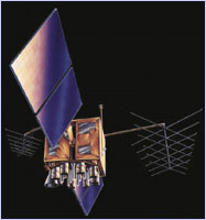 Satellites positioned around the world have enabled
pilots to use the Global Positioning System to
accurately determine their coordinates.
Satellites positioned around the world have enabled
pilots to use the Global Positioning System to
accurately determine their coordinates.
|
Aircraft safety only continues to increase with the new
technologies that have recently been developed. In 1983, the
first aircraft to navigate across the Atlantic entirely by use
of the Global Positioning System (GPS) landed safely in Paris.
Using satellites in space, pilots can pinpoint their position
on the globe with extreme accuracy.
More recently, new navigational systems have built upon the
success of GPS. In 1996, the Driver's Enhanced Vision System
became operational at Boston Logan airport. This equipment,
which uses satellite, digital, and infrared technologies,
assists emergency crews when visibility is limited by smoke,
flames, fog, or precipitation.
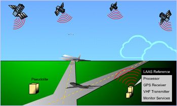 The Local Area Augmentation System (LAAS) may enhance
the accuracy of the Global Positioning System enough
to allow pilots to use GPS to make precision landings
with zero visibility.
The Local Area Augmentation System (LAAS) may enhance
the accuracy of the Global Positioning System enough
to allow pilots to use GPS to make precision landings
with zero visibility.
|
|
Even more cutting-edge technology is becoming available.
Today, pilots can make precision landings with zero visibility
using radio signals to guide them to the runway. Developers
are currently testing equipment to use GPS to land planes. In
order to do this, pilots need to know their location with even
more precision than GPS can offer. To provide this accuracy,
stations around the airport receive information from GPS
satellites, compare these data with their own exact location
(which they can determine with extreme accuracy), and send a
signal that will correct their GPS data. This system, called
the Local Area Augmentation System, is currently under
development and may eventually provide accurate,
less-expensive ways for airports to bring in their planes.
back to top
Photos/Illustrations: (1,3,5,7-9) National Archives/FAA;
(2) Courtesy of Boeing; (4,6,10) AlliedSignal; (11,12)
FAA.
Escape Through Time
| Skydive |
Human Response
Survivor Stories
|
Pioneers of Survival
|
Survival Strategies
Resources |
Teacher's Guide
|
Transcripts
| Site Map |
Escape! Home
Editor's Picks
|
Previous Sites
|
Join Us/E-mail
|
TV/Web Schedule
About NOVA |
Teachers |
Site Map |
Shop |
Jobs |
Search |
To print
PBS Online |
NOVA Online |
WGBH
©
| Updated November 2000
|
|
|