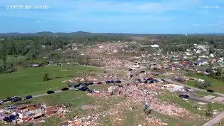
Deadly Tornado's Path Through KY Visible from Satellite
Clip: Season 3 Episode 253 | 5m 9sVideo has Closed Captions
As people begin cleaning up the tornado damage, more storms are headed for Kentucky.
Damage surveys continue in areas hit hardest by Friday night's severe weather. Christie Dutton takes a look at where tornadoes touched down across the state and who has the greatest risk of more severe weather on Tuesday.
Problems playing video? | Closed Captioning Feedback
Problems playing video? | Closed Captioning Feedback
Kentucky Edition is a local public television program presented by KET
Deadly Tornado's Path Through KY Visible from Satellite
Clip: Season 3 Episode 253 | 5m 9sVideo has Closed Captions
Damage surveys continue in areas hit hardest by Friday night's severe weather. Christie Dutton takes a look at where tornadoes touched down across the state and who has the greatest risk of more severe weather on Tuesday.
Problems playing video? | Closed Captioning Feedback
How to Watch Kentucky Edition
Kentucky Edition is available to stream on pbs.org and the free PBS App, available on iPhone, Apple TV, Android TV, Android smartphones, Amazon Fire TV, Amazon Fire Tablet, Roku, Samsung Smart TV, and Vizio.
Providing Support for PBS.org
Learn Moreabout PBS online sponsorshipAnd damage surveys do continue in areas hit hardest by Friday night's severe weather.
Our Christy Dutton shows us where tornadoes touched down across the state and who has the greatest risk of more severe weather tomorrow.
We're still waiting on the final count for the number of tornadoes that we experienced for Friday across the state of Kentucky, but we know there will be at least four.
We have an EF three tornado confirmed by the National Weather Service office in Paducah.
That's in Union County, near Morgan Field.
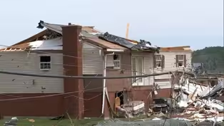
For injuries from that tornado, which reached 155 mile an hour winds did catastrophic damage to a lot of the homes in that area.
Two EF2 tornadoes, one in Hopkinsville near Caskey, and also one that started out in Christian County moving into Todd County, doing the most damage around Blue Hole Road and that area, both EF twos.
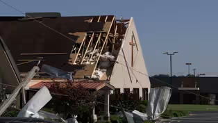
We still are waiting on the final report from the tornado that moved through Pulaski and Laurel County.
The deadly tornado there right now, a preliminary high end EF three tornado.
And we are continuing to watch for the reports coming out about that.
I spoke to a meteorologist from the National Weather Service out of Jackson, Kentucky, there in eastern Kentucky, about this deadly tornado.
Take a listen.
Our team here was, watching.
The storms are all through the afternoon and evening time frame.
This storm, actually, originated in Missouri and tracked across the entire state of Kentucky and then over to our area.
But, yes, we were tracking those storms all through the evening and in the afternoon.
So you all are going out and surveying the damage to determine the rating, the strength of the tornado.
Which areas are you surveying?
So we're surveying mainly, in Pulaski and Laurel County.
We will possibly be moving east some today.
As they're trying to wrap things up in, Pulaski or in Laurel County, rather.
So we will be, basically surveying that path, in those two counties for our CWA.
And then also as you move east, Louisville, was doing damage surveys in Russell County.
That was on Saturday.
Okay.
Did it look like it was the same tornado that moved through Pulaski and Laurel County, or two separate?
We believe right now that it's the same tornado.
There's actually a pretty defined track, even on satellite imagery.
Pretty much originating there in Pulaski County.
And going east into Laurel.
Do you all have any preliminary, estimates of the strength of that tornado?
Yeah.
Right now, a lot of the damage that we've seen has been, EF2 and upwards of EF three damage right now.
We, we actually have teams set up to, look at our data as well.
To start investigating.
These are like, folks that have expertise in higher end damage.
But it does look like a EF three and maybe high end F3 right now, but we're still investigating that.
Okay.
And when will you when do you expect to have the official rating?
That'll be, sometime probably over the next couple of days.
We'll probably have some preliminary data out today or tomorrow.
Okay.
And as we take a look ahead, we're expecting, you know, the the percent chance for storms today.
But really Tuesday afternoon and evening you all are focusing in on that.
Tell us what to watch out for.
Yeah.
So once again we get another round of severe weather coming in, Tuesday afternoon and evening.
Really?
All threats are on the table.
Once again, this does look like, more like lines of thunderstorms coming through the area.
And so maybe a little bit different, setup than last time.
And, right now there's no, you know, there's no definite on that.
We're going to have more tornadoes in this case.
But, we need to be watching out for that.
Tornadoes, hail, damaging winds.
So that's that's what we're going to be looking at, for Tuesday.
And really that afternoon and evening time frame look like to be, the best chance for seeing some severe weather across the area, as you just heard from Destin Jordan, as we continue to clean up from the storms that moved through on Friday.
We are now looking ahead to another round of potential severe weather.
A lot of Kentucky, under a risk of strong storms Tuesday afternoon and Tuesday night.
The highest risk is the enhanced risk over southwestern Kentucky.
We have a slight risk over much of central Kentucky and far eastern Kentucky.
We have that marginal risk, so we will keep our eye out.
All severe weather risks are on the table from damaging winds potentially isolated tornadoes, and also hail from these storms that will move through on Tuesday.
For Kentucky edition, I'm Christy Dutton.
All right.
Thank you so much, Christy.
And of course, we will continue to follow tornado response and recovery across southeastern Kentucky.
And the threat for any more potential weather that may move into the state as well.
Laurel Co. Families Looking For Housing After Deadly Tornado
Video has Closed Captions
Clip: S3 Ep253 | 2m 34s | Those lucky to survive the storm have uncertain housing for the near future. (2m 34s)
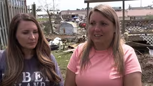
Laurel Co. Woman Recounts Tornado That Destroyed Neighborhood
Video has Closed Captions
Clip: S3 Ep253 | 3m 37s | One of the neighborhoods hit hardest in Laurel County was Sunshine Hills. (3m 37s)

Mondays on Main: Carlisle, Nicholas County
Video has Closed Captions
Clip: S3 Ep253 | 5m 4s | Carlisle in Nicholas County has been making major changes in the last few decades. (5m 4s)
Recovery Efforts Ongoing After Deadly Tornadoes
Video has Closed Captions
Clip: S3 Ep253 | 3m 3s | Recovery efforts are ongoing following a deadly tornado in Laurel County. (3m 3s)
Somerset Hammered by Deadly Tornado
Video has Closed Captions
Clip: S3 Ep253 | 2m 25s | At least one person was killed when a tornado hit Somerset on Friday. (2m 25s)
Providing Support for PBS.org
Learn Moreabout PBS online sponsorship
- News and Public Affairs

Top journalists deliver compelling original analysis of the hour's headlines.

- News and Public Affairs

FRONTLINE is investigative journalism that questions, explains and changes our world.


Support for PBS provided by:
Kentucky Edition is a local public television program presented by KET