FEMA Map Updates
Clip: Season 2 Episode 41 | 3m 2sVideo has Closed Captions
FEMA specialist Tim Russo talks about updating maps and assessing risk.
FEMA specialist in floodplain management and insurance Tim Russo talks about updating maps and assessing risk.
Problems playing video? | Closed Captioning Feedback
Problems playing video? | Closed Captioning Feedback
Kentucky Edition is a local public television program presented by KET
FEMA Map Updates
Clip: Season 2 Episode 41 | 3m 2sVideo has Closed Captions
FEMA specialist in floodplain management and insurance Tim Russo talks about updating maps and assessing risk.
Problems playing video? | Closed Captioning Feedback
How to Watch Kentucky Edition
Kentucky Edition is available to stream on pbs.org and the free PBS App, available on iPhone, Apple TV, Android TV, Android smartphones, Amazon Fire TV, Amazon Fire Tablet, Roku, Samsung Smart TV, and Vizio.
Providing Support for PBS.org
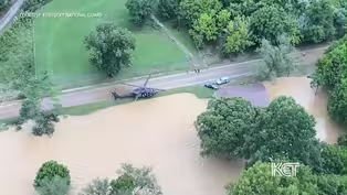
Learn Moreabout PBS online sponsorshipBy some counts, more than 80% of homes damaged or destroyed by last year's flooding were outside the designated high risk areas.
On the Federal Emergency Management Agency's flood maps, the maps are used to determine insurance coverage for property owners with federally backed mortgages and how communities regulate development.
But there are a growing number of complaints about FEMA flood maps being inaccurate and even out of date.
A FEMA specialist in floodplain mapping tells us the maps are updated more often than people think, but the updates can only come if a community asks for it.
The flood maps actually identify the high risk areas of flooding in each community.
Anything in that area does have a 1% annual chance of flooding, and that's every year.
Each community has a flood damage prevention ordinance.
Once they have maps.
And so anything within that high risk area has to follow that flood damage prevention ordinance.
So if that means elevating the lowest floor to, you know, above the base flood elevation, which is the base flood elevation determines the height of that structure with that first floor needs to sit inside the high risk area, which is one of the tools for resiliency.
And we use that all the time across the nation.
There's one misconception, and I'd just like to get this out.
It's usually after one a flash flood or a flood.
Usually people think, okay, FEMA's going to update the maps and we don't work that way.
They're on a five year cycle when we update these maps.
So a lot of times when disasters hit in these maps are a lot of people think the maps are going to be updated right away.
Right after that disaster declaration and that's not the case.
It's usually a five year cycle, but sometimes the communities are already in a process of updating their maps.
When when a disaster hits and usually we see this after a disaster, when a community does flood, they want to update their maps, specially after ten years old or older or something like that.
So what happens is if the community wants their map updated, they would get with the state.
And if I p coordinator and then say we need to get our maps done or we want to update our maps and then it goes from there.
Creating these maps requires funding.
So that also comes into play when we are updating maps as well in a 30 year mortgage.
If you get sea water, your house is potentially going to flood at least once.
If they have any kind of federal funds or if their loan is backed by any type of federal funds or anything like that, it's mandatory in a high risk area or special flood hazard area for that homeowner or even business to purchase insurance.
A lot of people that file for flood insurance after a disaster, a lot of them are outside, especially flood hazard area.
Anything that's out of high risk area, it's not required for them to buy flood insurance.
But we all know the water doesn't stop at the end of the map.
It keeps going.
Russo also said it's important for homeowners to know that FEMA maps don't predict where flooding will hit and that they need to talk to an insurance agent to help determine the overall flood risk to their property.
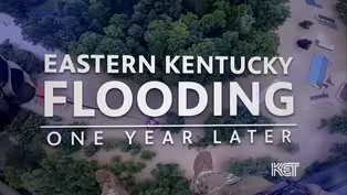
Eastern Kentucky Flooding: One Year Later
Video has Closed Captions
Clip: S2 Ep41 | 4m 40s | A look back on the one year anniversary of the historic flooding in Eastern Kentucky. (4m 40s)
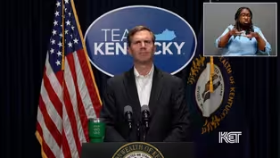
Gov. Beshear On Eastern KY Flooding
Video has Closed Captions
Clip: S2 Ep41 | 1m 5s | Governor Andy Beshear reflects on the Eastern Kentucky flooding one year later. (1m 5s)

One-On-One with Mayor Alan Keck
Video has Closed Captions
Clip: S2 Ep41 | 6m 19s | Mayor Alan Keck sits down with Renee Shaw to reflect on his gubernatorial run. (6m 19s)
Video has Closed Captions
Clip: S2 Ep41 | 3m 40s | One year after of the flooding in Eastern KY, volunteer fire department continues to help. (3m 40s)

Video has Closed Captions
Clip: S2 Ep41 | 2m 29s | Dee Davis telling the stories of those affected by the flood. (2m 29s)

Transportation And Addiction Recovery
Video has Closed Captions
Clip: S2 Ep41 | 2m 22s | The role of transportation services in addiction recovery. (2m 22s)
Providing Support for PBS.org
Learn Moreabout PBS online sponsorship
- News and Public Affairs

Top journalists deliver compelling original analysis of the hour's headlines.

- News and Public Affairs

FRONTLINE is investigative journalism that questions, explains and changes our world.


Support for PBS provided by:
Kentucky Edition is a local public television program presented by KET