G-I-S is C-O-O-L
Clip: Season 10 Episode 5 | 6m 20sVideo has Closed Captions
GIS consolidates information about the 3-D world. It can also help us understand history.
Have you ever heard someone mention the term GIS…as in Gee-eye-ess? Then that voice in your head says, I kind of, think I know what it is, but I'm not sure. Well, this video is for you. GIS stands for Geographic Information System. WFSU’s Mike Plummer explores GIS with the Tallahassee-Leon County GIS department.
Problems playing video? | Closed Captioning Feedback
Problems playing video? | Closed Captioning Feedback
Local Routes is a local public television program presented by WFSU
G-I-S is C-O-O-L
Clip: Season 10 Episode 5 | 6m 20sVideo has Closed Captions
Have you ever heard someone mention the term GIS…as in Gee-eye-ess? Then that voice in your head says, I kind of, think I know what it is, but I'm not sure. Well, this video is for you. GIS stands for Geographic Information System. WFSU’s Mike Plummer explores GIS with the Tallahassee-Leon County GIS department.
Problems playing video? | Closed Captioning Feedback
How to Watch Local Routes
Local Routes is available to stream on pbs.org and the free PBS App, available on iPhone, Apple TV, Android TV, Android smartphones, Amazon Fire TV, Amazon Fire Tablet, Roku, Samsung Smart TV, and Vizio.
Providing Support for PBS.org
Learn Moreabout PBS online sponsorshipYou may or may not have heard the term G-I-S.
It stands for Geographic Information System.
It may sound like a pretty dull subject, but it is truly incredible what GIS can tell you about the world around you.
Something else you may not be aware of is that a ginormous amount of this information is available to you, online, for free.
So everything we see app in somewhere, right?
There's a location for everything.
And that's where GIS is so different than other information systems.
It's geographic.
So we have coordinates associated with all those features that we're collecting that we keep within the system, and we're able to ask questions like, for example, fire hydrants are mapped.
If I wanted to ask how many houses are within a half mile of this fire hydrant?
I get that answer very easily, very quickly.
And that's a simple example.
A lot of research was conducted on how parcels of land transfer to family members and some of that research, which we had to research deeds, warranty deeds and and that sort of thing, surveys and tie back to development at specific times.
Most people would probably associate this kind of information with records as in public records, but actually it's also history as in our history.
And it so happens that our own Tallahassee, Leon County GIS Department has started to integrate these various geographic records into the story of our history.
Story Maps is a product that allow you to engage a storytelling.
And it allowed us to provide all different types of content.
So we can do audio, video, text, pictures.
And we've managed to source out information on, you know, notable people, notable names.
One of our projects started out as a street naming project, which we wanted to know who the the names were, the individuals that the streets were named after and for namesake, for example, or names, faces, and places.
We attempted to do that and we identified some of those individuals, notable people, governors, community leaders and they've they've had a story to tell.
And we tried to manage to tell that story in a way that is informative and fun.
And of course, the bicentennial has come up and the timing is just perfect for that.
We've got lots of content that a lot of museums, historians, archeologists, have just been, you know, so excited about.
It's we've really branched out.
All right.
So kind of drive me through this thing.
All right.
First, do you see the Bicentennial 200 logo here?
Yeah.
As we scroll down, you see the time period from 1824 to 2024, and we have quite a few hearings here.
Government, the historical sites, heritage neighborhoods, farmer's market, living history, and also pictures of the bicentennial meeting.
The reason why we selected this is is is in true form of the 1924 and the 1974 celebration.
We took that format and kind of mimic that format and provided some additional content in there.
And we started with the government.
Okay.
Seat of government state here?
We have information about when the the state was formed, the treaty that was signed here, and this is a replica that was built in 1974 of the historical capital.
The Heritage neighborhoods, that there were groups of areas around old Tallahassee that were considered to have their own identities.
Yes.
Los Robles is one.
Calhoun historic district.
This first one is Magnolia Heights.
We're working on this one right now.
One of the neighborhoods that I found especially interesting was Myers Park.
The particular houses that were highlighted for local history.
Also had associated map locations along with public metadata.
And finally, we have to mention the Florida prime meridian.
This is the land marker that all land surveys in Florida and Alabama, a reference to going back to 1824 after the territory was acquired from Spain.
The meridian is the actual prime meridian, which is the marker for the public land survey system where it started in Florida when the United States acquired it.
If you look at the pavers here, this one one is going north-south.
Yeah, that is the meridian, the primary Meridian Okay.
And this line also follows the...the street Meridian Road follows this particular line, and the East-West one is the baseline.
And that is where at this intersection is the store of surveying in Florida.
And also this is the southwest corner of the Lafayette Land Grant.
Local GIS information and history are continuously being updated and added to.
And free access is at your fingertips.
TLC, GIS, dot org.
Somewhere online for WFIU Public Media.
I'm Mike Plummer.
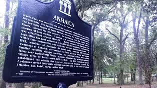
Anhaica Historical Marker|Tribute to History
Video has Closed Captions
Clip: S10 Ep5 | 2m 33s | The Tallahassee Historical Society pays tribute to Native history in our community (2m 33s)
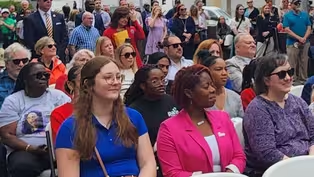
Kick off to Tallahassee's Bicentennial Celebration
Video has Closed Captions
Clip: S10 Ep5 | 2m 46s | The state and city kick off their Tallahassee Bicentennial celebrations with early events in 2024. (2m 46s)
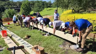
Tallahassee's Bicentennial Capitol Cabin | Building History
Video has Closed Captions
Clip: S10 Ep5 | 3m 54s | Tallahassee celebrates it's bicentennial by building a replica of the First Florida Capitol Cabin. (3m 54s)
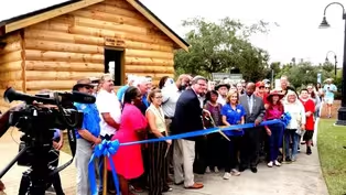
Tallahassee's Bicentennial First Capitol Log Cabin | Ribbon Cutting
Video has Closed Captions
Clip: S10 Ep5 | 2m 35s | On October 4th, 2024, the community cut the ribbon on the brand new First Florida Capitol Log Cabin (2m 35s)
Providing Support for PBS.org
Learn Moreabout PBS online sponsorship


Support for PBS provided by:
Local Routes is a local public television program presented by WFSU