Record-Breaking Rainfall
Clip: Season 3 Episode 223 | 3m 23sVideo has Closed Captions
Meteorologist Shane Holinde with the Kentucky Mesonet talks about the record-breaking rainfall.
Meteorologist Shane Holinde with the Kentucky Mesonet talks about the record-breaking rainfall and the next weather warning that goes into effect overnight.
Problems playing video? | Closed Captioning Feedback
Problems playing video? | Closed Captioning Feedback
Kentucky Edition is a local public television program presented by KET
Record-Breaking Rainfall
Clip: Season 3 Episode 223 | 3m 23sVideo has Closed Captions
Meteorologist Shane Holinde with the Kentucky Mesonet talks about the record-breaking rainfall and the next weather warning that goes into effect overnight.
Problems playing video? | Closed Captioning Feedback
How to Watch Kentucky Edition
Kentucky Edition is available to stream on pbs.org and the free PBS App, available on iPhone, Apple TV, Android TV, Android smartphones, Amazon Fire TV, Amazon Fire Tablet, Roku, Samsung Smart TV, and Vizio.
Providing Support for PBS.org
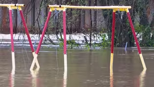
Learn Moreabout PBS online sponsorshipAnd earlier today I spoke with meteorologist Shane Holland with the Kentucky Mesonet about this record breaking rainfall and our next weather warning that goes into effect overnight.
Shane so when we talk about this historic rainfall, how much rain are we really talking about, say over a five day period throughout the state?
Well, incredible rainfall tallies from both, cooperative observers or observers for the National Weather Service, along with Kentucky Mesonet to the tune of double digits, most of that coming in the three day span between April 3rd and April 5th.
And in some cases, we saw more than a foot of rain.
Marshall County in the Far West being the big winner.
We're over 15in of rain fell in just three days time.
That was near Benton, Kentucky.
Well, and this was a little different than, say, the last flooding event where Eastern Kentucky was hit very hard.
They actually had some of the lighter rainfall totals over this time, which we're thankful for.
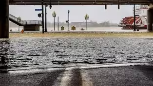
So in western Kentucky, seeing the most, but right now we're still dealing with ongoing river flooding.
Tell us about that.
Right.
So all that water had to go somewhere.
And the rivers, the creeks, the tributaries, that's where it's all going.
We've seen the barren over Lake Crest at a record level to 585.7ft, besting the old mark there set back in March 1989.
The green River continues to rise.
It is cresting today.
We're Barry in Butler County.
It is yet to crest further downstream in Paradise and also in Calhoun, which is in McLean County.
That crest will come until later this week.
And that's simply because the river is kind of backed up right now.
All the tributaries feeding into that are still very waterlogged, so it's going to take several days for the green River to actually crest at all points.
And then several days beyond that to gradually fall.
And the same is the case goes for the Ohio River near the Louisville area.
We're expecting a crest in the next couple of days, perhaps on Wednesday, so it could even go up another 2 or 3ft from where it is now.
And that is typical.
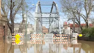
And this is a good time to remind people about turn around, don't drown about crossing those flooded roadways.
Right.
Exactly.
We still have numerous roadways in Warren County and around Bowling Green that are completely impassable.
That is the case for many counties across central and western Kentucky.
So even if a roadway is not barricaded, it does not mean that it is passable by any means.
So even if you're driving in a big Ford F-150 or a Chevy Silverado, you think you might be able to make it.
You never know how deep that water is, and it only takes one foot of water to lift.
Most vehicles off the roadway.
Two feet will lift any vehicle off the roadway.
So that's why we say turn around, don't drown.
Yes, absolutely.
And so, switching gears from rain to the temperatures, we go into the deep freeze tonight.
What's that going to be about?
They're talking about weather whiplash.
And from one extreme to another, we're looking at a freeze warning.
Now for much of the Commonwealth overnight into the early morning hours of Tuesday.
Temperatures are expected to drop to the 25 to 30 degree range across much of the state.
Thank you Shane.
Well, from flood to freeze.
As you just heard, these temperatures for most of the state will drop to the 20s overnight tonight.
And for some the 20s again overnight tomorrow night.

"Dukes of Hazzard" Star Headlines Concert for Flood Victims
Video has Closed Captions
Clip: S3 Ep223 | 3m 2s | The Foundation of Appalachian Kentucky will hold a special Flood Relief Concert in Hazard. (3m 2s)
Evacuation Orders Lifted for Two Northern Kentucky Cities
Video has Closed Captions
Clip: S3 Ep223 | 34s | Evacuation orders have been lifted in the cities of Falmouth and Butler in Pendleton County. (34s)
Video has Closed Captions
Clip: S3 Ep223 | 1m 49s | Governor Andy Beshear's office is warning people that this isn't over as the death toll is now two. (1m 49s)
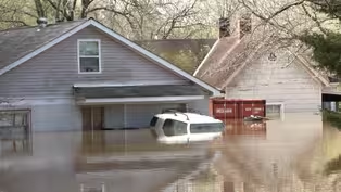
Floodwaters Force Families from Homes
Video has Closed Captions
Clip: S3 Ep223 | 2m 5s | Floodwaters forced several families from their homes in Woodford County over the weekend. (2m 5s)
Kentucky River Approaching Record Heights
Video has Closed Captions
Clip: S3 Ep223 | 2m 15s | In Frankfort, people are keeping a watchful eye on the Kentucky River. (2m 15s)

Video has Closed Captions
Clip: S3 Ep223 | 4m 43s | USDA cancels the next round of a program designed to help get local food into school cafeterias. (4m 43s)
Providing Support for PBS.org
Learn Moreabout PBS online sponsorship
- News and Public Affairs

Top journalists deliver compelling original analysis of the hour's headlines.

- News and Public Affairs

FRONTLINE is investigative journalism that questions, explains and changes our world.


Support for PBS provided by:
Kentucky Edition is a local public television program presented by KET