Saint Paul Past
Season 4 Episode 8 | 40m 33sVideo has Closed Captions
See how four key places in St. Paul helped shape the city's past and present.
See how four key places: the lower landing, Merriam Park, Summit Avenue, and Rondo, helped shape and define St Paul's past and present. The program also introduces some fascinating people, whose names would eventually be connected with famous novels, historic landmarks, and St Paul streets.
Problems playing video? | Closed Captioning Feedback
Problems playing video? | Closed Captioning Feedback
Minnesota Experience is a local public television program presented by TPT
Saint Paul Past
Season 4 Episode 8 | 40m 33sVideo has Closed Captions
See how four key places: the lower landing, Merriam Park, Summit Avenue, and Rondo, helped shape and define St Paul's past and present. The program also introduces some fascinating people, whose names would eventually be connected with famous novels, historic landmarks, and St Paul streets.
Problems playing video? | Closed Captioning Feedback
How to Watch Minnesota Experience
Minnesota Experience is available to stream on pbs.org and the free PBS App, available on iPhone, Apple TV, Android TV, Android smartphones, Amazon Fire TV, Amazon Fire Tablet, Roku, Samsung Smart TV, and Vizio.
Providing Support for PBS.org
Learn Moreabout PBS online sponsorship(television scrambling) (bright music) - [Announcer] The following is a special edition of "KTCA Reports."
(bright music) - [Announcer] "River, Railroads and Rondo" is made possible in part by contributors to The Saint Paul Foundation in celebration of the 150th anniversary of the naming of Saint Paul.
- Saint Paul is a city of hills, and this one is known as Dayton's Bluff.
And for as long as people can remember, Saint Paulites have come up here to this spot to view their city and to look inward into themselves.
Native Americans for hundreds of years viewed this as a ceremonial spot and came here to bury their dead in the nearby mountains.
150 years ago, a Catholic priest named Lucien Galtier came to a place on the river below known as Pig's Eye.
Galtier built a small chapel above the river.
The name of that primitive church gave the city the name we know today.
(bright music) And throughout the last century, Dayton's Bluff was the best perch to watch the new town on the river grow.
(bright music) Photographers climbed the hill to capture the gathering of homes on the river bend.
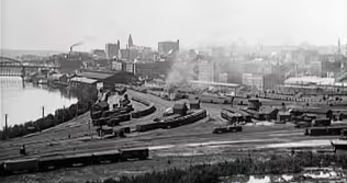
(bright music) Railroads joined the scene, curling into town on trestles along the Mississippi's eastern bank.
In time, the center view was no longer the river.
The focus shifted to the rail yards and the big downtown buildings.
(bright music) (train chugging along) The big railroad yards, the State Capitol on the horizon, the highways cutting through the old river, Dayton's Bluff is a spot that instantly helps you understand what Saint Paul is all about.
And during this program, we'll introduce you to the interesting stories of four key places that, like Dayton's Bluff, helped define Saint Paul's past and present.
(bright music) Below me is Saint Paul's old lower landing.
Those few of us who know about this place, know it by its modern name, Lambert's Landing.
Several times each summer, large river boats come up from St. Louis and dock right here.
(playful music) It's all for show these days.
The passengers are all tourists and they pull into a landing that isn't anything more than 10 feet of concrete squeezed up against an old highway.
It isn't much of a welcome.
(upbeat music) But Saint Paul's lower landing was once one of the busiest steamboat levies in the country.
In the year 1858, when Saint Paul became the capital of the new state of Minnesota, more than 1000 steamboats landed here taking advantage of a natural sandy levy at the break in the Bluffs.
The state's new residents were quite impressed.
- [Narrator] "Less it be steam.
"It is the very pulse of the world.
"On the Mississippi, the liquid highway of our continent, "how many old acquaintances are found?"
The Saint Paul Pioneer Press.
- [Hy] The boats brought thousands of people and finished goods from places like St. Louis and Galena and Rock Island.
Boats filled with products you couldn't make here like good dining room chairs.
The river was the big road into town, and Saint Paul was the end of the line.
Geography made the lower landing the region's commercial center and our Ellis Island.
And because of the need to get the big boats in and out, the natural river began to change.
Almost everything you see today along Saint Paul's riverfront has been altered.
Native Americans who canoed this river and hunted along its marshy bank wouldn't recognize it.
The Mississippi wasn't the straight narrow channel it now is.
To get back to that time, imagine the river much wider, in some places stretching nearly bluff to bluff.
And since it hadn't been dredged yet, the river was much more shallow.
A person could actually walk across the river here during a dry summer.
And if you weighted the river, you had places to stop and rest.
Harriet Island was once a real island.
It didn't become landlocked until the 1940s when the river channel to the south was closed off.
And besides Harriet Island, there were other sandbars and spots of land, including several small unnamed islands opposite the old landing, all sorts of things to get in the way of navigation.
But the town needed the boats and the boats needed room, and so over time, the river was tamed.
After statehood, the river changed in other ways too.
About the time of the Civil War, another steamed vehicle joined the river boats in the photos of the landing.
The trains had come and they found that the easiest route into town was along the shore of the river.
The coming of the rails would forever change the lower land.
No one knew this better than railroad baron, James J. Hill, who started his career as a steamboat agent on the lower landings levy.
Even when Hill became one of America's richest men, he still used the lower landing and nearby Lowertown as the base of his railroad empire, an empire whose future seemed certain.
- [Narrator] "When we all are dead and gone, "the sun will still shine, "the rain will fall, "and this railroad will run as usual."
James J. Hill.
- Passengers took the trains of Hill and others, and by the 1870s, the river was no longer the way folks rode into town.
The riverfront filled with more and more railroad tracks, and to make room for them, the river changed some more.
The river bluffs were cut back along downtown and near Dayton's Bluff, but it was more than just railroad tracks that sprung up along the river.
These once marshy riverbanks were filled in and became floodplain neighborhoods.
Because it was the cheapest housing in town, these neighborhoods would be where many of the city's ethnic groups first settled.
If you go upstream from downtown Saint Paul here along Shepard Road, before you come to the high bridge, you'll come upon this little street called Elm.
Two things you'll notice about the street.
One, there are no elms, and two, it goes nowhere.
But before 1960, this was an important area moving into a community called Little Italy.
Little Italy's first residents, oddly enough, weren't Italians at all.
They were immigrants from Poland who built shacks in the 1880s.
But soon after, the Italians began to move in.
And by the 1930s, the neighborhood swelled to over 400 people.
Three quarters of the residents were from Italy.
The small houses sat beside dirt streets, but you can't see any dust in most of the photos that remained.
That's because the neighborhood was often pictured underwater.
In early spring, many times Little Italy saw flooding, as did the neighborhoods on the other side of the river, where Eastern European Jews and later Mexican Americans lived in similar small homes.
These riverfront neighborhoods survived numerous floods over time.
To many, the worst was the devastating high water that came the spring of 1952.
(bright music) (camera reel running) All of Saint Paul's riverfront was underwater and, in Little Italy, streets were flooded and the water rose to the first floor of the houses.
One of the people whose family lived in Little Italy then was Stan Fedora.
- We never did get any warning.
That was always on the verge, on the brink the flooding for many, many times.
Said, "Well, we gotta go, hey, the water's coming up.
"Ah I'll never go."
"Yes, it will."
"Oh, no it won't."
"Yes, it will.
No it won't."
Well, it finally came.
They were up three, four feet around every house and everybody's basement was flooded.
I told them, I said, "Well, I tell you what we will do.
"You row the boat and I'll be looking "from the rear of the boat.
"While you're rowing it, I'll take the pictures" So as we rowed around the whole levy, I was the cameraman with hip boots, and they were rowing the boat.
And so we went up and down each street in the alley, they called it the alley.
A couple of side streets they called Elm Street, Wilkins Street, Andora street, three of those alleys, but they weren't named.
All along the streets, I can picture the homes, the way they looked.
They had all wooden fences.
I could picture every little detail of those homes down there.
- After the 1952 flood, the Italians began to move out of the neighborhood.
The last home was torn down in 1960.
Little Italy was gone and not much was left of the nearby lower landing either.
The landing's last gasp came during the Great Depression when Saint Paul constructed an impressive WPA-style dock in a final romantic push to revive riverboat traffic.
Dubbed Lambert's Landing, the city hoped passenger boats and general cargo trade could give the railroads a run for their money.
And some river boats did stop there, but not many.
In the 1950s, most of the old landing was removed.
It gave way for the construction of Shepard Road.
(traffic passing) The lower landing, for all practical purposes, is gone.
So are the nearby riverfront neighborhoods.
The old steam boats have vanished too, although barge traffic has increased in the past few decades.
The once wild river has been lined with concrete banks with a dam north of the town and one south.
The river of Mark Twain is now referred to by government engineers as pool number two, and the downtown which once clung to and depended on the Mississippi has now turned its back to the river.
(gentle music) You wouldn't know it now, but late in the last century, this was a very, very busy spot on the Milwaukee Road rail line.
This was the Merriam Park Station of that line.
You can go up to a station agent in Chicago and ask for a ticket to Merriam Park, Minnesota, and he knew what you were talking about.
And the local residents living around here could commute to either Minneapolis or Saint Paul from this spot on the line.
And it would take 12 minutes to either place.
There's still a Merriam Park neighborhood, and the old park itself still exists.
But there's little to suggest that right here in the Midway district, 100 years ago, a small group of dreamers hoped to create the new center of the twin cities, the new downtown.
And if the plan had worked, this quiet neighborhood would now be the home of the State Capitol building and the Catholic cathedral.
The idea wasn't as far fetched as it first sounds.
(jovial music) Merriam Park was planted in 1882 by railroad investor and land speculator, John Merriam, who was also once the speaker of the Minnesota State House.
When James J. Hill completed a rail line through the Midway, Merriam brought up the adjoining land.
Merriam Park was outside of the city limits of both towns back then, but it soon became a fashionable Saint Paul's suburb, built around a Victorian central park complete with rolling paths and a fountain.
It was a good address.
John Merriam's son, William, became governor of the state in the late 1880s.
The younger Merriam was a good friend of Archbishop John Ireland, who was busy building St. Thomas College nearby.
A third mutual friend was James J. Hill, whose shortline railroad tracks between Minneapolis and Saint Paul ran through the neighborhood.
These three men, Merriam, Ireland and Hill, had a wild notion of what Merriam Park should become.
This is the eighth hole of the Town and Country Club golf course.
Believe it or not, The people in the neighborhood believed that the State Capitol would be built right here across the street from the golf course.
John Merriam himself donated 20 acres of land for this purpose.
(upbeat music) You see, the state desperately needed a new capitol.
The first State Capitol was constructed in the 1850s.
It was expanded several times during the next few decades, when major wings were added.
By the 1880s, state government had already built and outgrown two state capitols, both located downtown and each so undistinguished that their site isn't even marked today.
The second Capitol had been hastily constructed and by all accounts it wasn't big enough, which was convenient because no one liked the looks of it either.
So when the debate began over where to build a new capitol, Merriam Park was a popular choice.
The most enthusiastic supporter of the capitol plan was the area's weekly paper, "The Midway News," which frequently published maps showing the location of the new capitol on a spot it dubbed, "Capitol Hill."
Archbishop John Ireland became the semi-official public booster of the project.
Ireland was a remarkable figure, a charismatic leader in the American Catholic church, friend of governors and presidents, and a big friend of the Midway.
Ireland had broken ground in the area for St. Thomas College, and it was here in the Midway that Ireland dreamed of uniting Minneapolis and Saint Paul into a city he liked to call, "Paulapolis."
- [Narrator] "Tread reverently upon this ground.
"It is the Midway, "the very heart of the coming great city.
"Look at it.
Admire it.
"It is the precious gift by which Saint Paul will woo "and win fair Minneapolis."
Archbishop John Ireland.
- [Hy] Ireland supported the Midway with much more than his words.
He used his own funds to speculate in nearby real estate in anticipation of the pending developments.
He owned many lots in the neighborhood.
And one source says, in a moment of optimism, he even began laying the foundation of his new cathedral here in the Merriam Park neighborhood.
It was to be across from the chapel at the college of St. Thomas on the corner of Laurel and Cleveland, on land now occupied by an apartment building with a Vietnamese restaurant in its basement.
Railroad baron, James J. Hill, was interested in Merriam Park too.
He joined in the enthusiasm of his old friend, the Archbishop.
With extensive tracks in the area, Hill said he would build his new union depot here if the Capitol would be located here.
In January of 1893, state leaders awaited word from the State Capitol commission as to where the new Capitol would be built, and there was one last furious public debate.
- [Narrator] "To remove the Capitol to the outer rim "of the municipal area would be a disaster to all.
"We cannot afford to have any Capitol scandal in Minnesota."
"The Saint Paul Pioneer Press."
"A large portion of the best people in Saint Paul, "and pretty much all of the people in Minneapolis, "favor a Midway site, "but the Minneapolis delegation is coerced into silence "by the Saint Paul downtown gang "of which the Pioneer Press is the official organ.
"The Midway News."
- [Hy] In the end, the arguments of the downtown gang won.
To many minds, the Midway was still located too far from either town center.
It was too undeveloped.
There were rumors about the whole plan being the work of real estate speculators.
And potential ally, now ex-governor, William Merriam, concerned about the appearance of conflict of interest could not publicly support the Merriam Park proposal.
(bright music) So in 1893, when the state committee settled on the site for the new Capitol, the Midway site lost out.
Merriam Park would never become a household name, and there would be a price to pay for that.
Archbishop Ireland had bought hundreds of home sites in the Midway, and on the heels of the downtown Capitol decision came the panic of 1893.
Ireland had to turn to his friend, Hill, to get him out of financial trouble.
Records show that he'll loaned Ireland more than $100,000 to pay off his debts.
Hill also got his Eastern friends, including the Rockerfellers and the Vanderbilts, to secure money for the Archbishop.
Minnesota soon began and completed its fine new State Capitol at a cost of $4 million.
$30,000 of that was paid to ex-governor William Merriam.
It turns out that the downtown capitol site just so happened to include land that he owned.
The new Capitol would have something to do with the name Merriam after all.
Golf courses that could have been capitols, Vietnamese restaurants that might've been cathedrals, dreams of being the big railroad hub, here in Merriam Park anything seemed possible.
And in the classic Saint Paul tradition, the lines between church, business and state, all blurred.
(gentle music) (upbeat music) By the time the century turned, so had the fortunes of Saint Paul.
It was no longer the state's biggest city.
Minneapolis was, and Saint Paul didn't like this second city business a bit.
The city struggled to claim its own identity.
It was still the capital.
It was also the older city.
And as we see in this rare 1917 newsreel, Saint Paul played up its frontier past for all the world to see during the city's winter carnival festival.
(upbeat music) (children squealing) But while Saint Paul was the city of winter and of the past, bustling forward-looking Minneapolis was the city of summer, and Saint Paul city leaders seemed to know that.
It was almost as if Saint Paul decided to let Minneapolis try to be Chicago as it attempted to be Boston.
Minneapolis would have its big city commerce and its numbered and alphabetized streets.
Saint Paul would have its smaller building, its neighborhoods, and its tradition.
It would have Summit Avenue.
(upbeat music) - [Narrator] "I don't know of any lovelier view "than when you stand on Summit Avenue "and you look across Lowertown "to the Mississippi cliffs below."
- Those words were written by a famous author who lived here in this Summit Avenue house during the winter of 1917-1918.
And the author was not F. Scott Fitzgerald.
The author was Sinclair Lewis, and the words are from his famous masterpiece, "Main street."
Sinclair Lewis came here in 1917, not to work on Main Street, but rather to work on a novel about James J. Hill, who lived down the road on Summit Avenue, not far from this building.
That same winter that Lewis rented this home, which he called, "The Lemon Meringue Pie House," here at 516 Summit, Princeton student, F Scott Fitzgerald, listed his residence up the street at number 593, a few doors down in the same building from his family's famous 599 address.
There is no record that they met that winter, but if the two writers had bumped into each other, they likely would have disagreed over what Summit Avenue represented.
Lewis was drawn to the street.
He used to stroll down it when he came to the cities in his youth.
To him, it showed Midwestern ingenuity and culture.
During his stay on Summit, Lewis wrote to a friend.
- [Narrator] "We've come out for the winter and spring "in this middle western environment, "watching the solid, stolid, real America "in all its faults and virtues.
"And there is an easy friendliness here, rather pleasant.
"also lower rent."
- [Hy] Lewis' wife, Grace, documented the stay with a series of snapshots of the house.
In one photo, Lewis appears as a shadowy figure on the front porch.
She also took shots of the rear of the house, taking care of the note items such as her bed in an upstairs window and the couple's baby carriage in the driveway.
Other snapshots show Grace in front of the Summit house holding Wells, the couple's only child.
This photo caption reads, "We are 15 weeks old."
The Lewis's seemed to like it on Summit Avenue.
Fitzgerald, however, saw a different Summit, and felt the need to write about it during the late '20s.
In one short story, a Fitzgerald character gives the reader this sombre tour of the avenue where he grew up.
- [Narrator] "The new cathedral squatted "like a plump white bulldog on a haunches, "followed by a half mile of pretentious stone houses "built in the gloomy '90s.
"The avenue ran along the bluff, "but neither faced it nor seemed aware of it, "for all the houses fronted inward toward the street.
"This is our show street, "a museum of American architectural failures."
- [Hy] By the time Fitzgerald wrote those words, he and his wife, Zelda, had left Saint Paul to go out east.
In 1930, Sinclair Lewis became the first American writer to win a Nobel Prize.
- Advice to young writers is very simple.
They have to do only a few things.
They have to learn to write almost perfectly, and then keep it up all their lives.
They'll probably fail.
- [Hy] By then, Lewis too was long gone from Saint Paul.
He never wrote his novel about James J. Hill.
(bell chimes) Summit Avenue has changed little since the days of Lewis and Fitzgerald.
It is still dominated by the overscaled cathedral dome.
It is still home to the grandest residences in the city.
And at the end of the street, rest assured you can still find James J. Hill's house, dark and brooding.
As it did in earlier times, the street still projects a strong sense of culture, a feeling of importance.
And it has been a destination for new generations of writers, including humorous, Garrison Keillor, and essayist, Patricia Hampl.
And here on Summit, one can still feel the cultural tug of war that Lewis and Fitzgerald represented.
(gentle music) (upbeat blues music) - [Narrator] "I done strum along and strum along, "going this way and that.
"Whatever way would lead me to a moment of peace.
"That's all I want, "to be as easy with everything.
"But I wasn't born to that.
"I was born to a time of fire."
(upbeat blues music) - Noted American playwright, August Wilson, wrote those words.
He lived in the Summit Hill neighborhood during the 1970s and 1980s, but he wasn't writing about the experiences of the Summit Avenue elite.
Rather, he was concerned about the people who lived here, north and west of there.
Here in the neighborhood of Rondo of Saint Paul, where the black community lived.
Nothing much is left of old Rondo now.
I-94 took care of that.
(traffic zooming by) You're never too far from the highway here in Rondo.
Almost everywhere you go in the neighborhood, it follows you.
It's drone is always there.
(traffic zooming by) - Stop it (laughs)!
- Well, you know- - Evelyn Fairbanks knows that sound.
She grew up in Rondo and lost her home to the highway.
When we arranged an interview with Evelyn, we picked for a site, this vacant lot on Saint Anthony Avenue, her old street.
The lot turned out to be right next door to the condemned house where her brother, Oscar, used to live.
Rondo, we quickly learned, is a small world.
- The Blairs lived here downstairs.
They owned this house.
And when their daughter, Fredie, her name was for Fredonia, when her daughter Fredie married my brother, they came to live here upstairs.
So I visited this house quite a lot.
It was a pretty fancy house.
This was on the hill.
It was past Dale.
Dale was our dividing line as to when you were pretty fancy.
- [Hy] So it was in front of her brother's house where we talked to Evelyn about growing up in Rondo.
- Saint Paul is a very clannish town as a whole, and each particular part is clannish.
So the African-Americans in Saint Paul are very clannish.
It takes a while to get in.
They will welcome you on the outside, but to be a part of...
But then when you are let in, you're at home.
and you know that.
You know that!
(upbeat blues music) - [Hy] Rondo was where Saint Paul's black community lived, but it was not an exclusively black neighborhood.
For most of the century, it was a racially mixed neighborhood.
It was the kind of place where the local community center, the Hallie Q.
Brown Center, had a Black Santa.
But while most of the children who came to Hallie Q.
Brown were Black, some of the kids who sat on that Black Santa's knees were White.
But there were special occasions when Black Saint Paul gathered together all by itself.
There were numerous Black churches where African-Americans came to worship, and there were the neighborhood's social clubs.
- The Elks Club was Black.
And I didn't even realize that there was a White Elks.
I thought the only Elks were Black, and as they traveled throughout the country, they went to the Elks.
It was a place that strangers from other parts of the country could go and be welcomed as brothers and sisters.
And they had a parade, they had a marching unit.
And that was one of the proud moments of being Black, because, of course, no white group could do that, because they hadn't done it.
But they had the different beat and the different step.
And oh, that was marvelous!
- [Hy] This film was shot in the early '50s.
And by the end of the decade, Saint Paul's Black community would change in a profound way.
The government was busy planning highways.
And the first interstate section in Saint Paul would be built right through the heart of Rondo.
And so, with little public outcry, block after neighborhood block was cleared to make room for the big road.
(upbeat blues music) Hundreds of homes were condemned and torn down, including the house where Evelyn grew up.
At first, the road didn't really go anywhere.
It was just a ribbon of white dropped into Saint Paul's Black neighborhood.
It wouldn't be years before the highway hooked up to the east or the west.
But finished or not, the highway had come.
There had never really been any hope of stopping it.
The neighborhood had to settle for one small victory.
The original plans called for the roadway to be elevated for much of the route through Rondo.
After strong neighborhood protests about an elevated route, highway engineers agreed to put the highway in a sunken trench.
This is the warehouse at the Department of Transportation, where files upon files are kept for thousands of state residents who lost their homes for I-94.
Here in these files are the records of the 400 Rondo neighborhood homes that were torn down for the interstate.
Fully 300 of these homes belonged to Black households.
One of every eight Blacks living in the city at the time lost a home to the freeway, and each has a file in this room, including Evelyn.
Evelyn hadn't seen her house in 30 years before we uncovered photos of it stapled in our her highway department file.
- Oh my goodness!
Look at that.
Isn't that something?
You know, a child, to a child, you don't see the upstairs.
Oh my goodness.
This is unreal.
That's where it was.
And I slept right in the front bedroom right in there.
And those are the stairs going upstairs.
And the house next door, that was a nice house.
That was a nice house!
My whole childhood.
And that's deer on the hollyhocks.
They're there.
Oh man.
Oh man!
- [Hy] Evelyn's neighborhood has changed a great deal since 1960, when the old homes were torn down and replaced by entrance ramps and frontage road apartments.
The highway accelerated the changes going on in the neighborhood.
In 1950, most of the people in Evelyn's part of Rondo were white.
By 1968, after the homes were cleared, most of the neighborhood was Black.
Today, Evelyn's old neighborhood is changing again.
It is still mostly Black, but in the past several years, southeast Asians have moved into the area and opened businesses in the neighborhood.
The city's fastest growing ethnic group, the Asians, now outnumber Whites in some parts of old Rondo.
But it is the Black community that best remembers what Rondo once was.
- I'm was standing on my front porch.
(traffic zooming by) This is a strange feeling to realize that this was there.
These are the same weeds, the same seeds, the same root system.
This was all under there all the time.
Grass was fun, you see.
Especially this kind.
You know, that's why you- (Evelyn blows grass) You did that a lot as a kid.
You know, when I was a child, we could get out in that street and play a whole baseball game without a car coming by.
And now look at them.
Holy cow!
And this isn't even rush hour (laughs)!
Look at that!
I don't like this freeway!
(laughs) I don't like it!
Let's go!
(traffic zooming by) (gentle music) - [Hy] We began telling our stories by talking about the city's first highway, the river, and of its first travelers, the Indians, who built sacred mounds along its bluffs.
We talked about how the railroads became the highways, making Minneapolis the big city and allowing neighborhoods like Merriam Park to grow far from downtown.
And we saw how years later, the interstates cut their paths through the city, slicing through neighborhoods like Rondo.
Perhaps the interstates have brought the most change.
The highways have made downtown less important, less special.
And in a world where a person can live in Saint Paul, work in Bloomington, and shop in Maplewood, the highway seemed to make neighborhoods less important too, and they make things less sacred.
A highway even cuts between the Capitol and the cathedral.
(gentle music) For decades, Saint Paul has understood itself by thinking about its grand twin domes, both built within the same decade at the turn of the century.
Few people in town are sure which is taller or can quite remember which came first.
In a way, they are interchangeable, each inspired by the Renaissance, each representing a world of truths.
Saint Paul's domes have always stood for noble government, and powerful church, and Summit Avenue-style culture, all things that are now challenged and changing.
(gentle music) - [Announcer] "Rivers, Railroads and Rondo," was made possible in part by the following contributors to the Saint Paul Foundation in celebration of the 150th anniversary of the naming of the city of Saint Paul.
(dramatic music)
Video has Closed Captions
Preview: S4 Ep8 | 30s | See how four key places helped shape and define St. Paul's past and present. (30s)
Providing Support for PBS.org
Learn Moreabout PBS online sponsorship


Support for PBS provided by:
Minnesota Experience is a local public television program presented by TPT