USGS WaterAlert System
Clip: Season 3 Episode 52 | 4m 7sVideo has Closed Captions
How one eastern Kentucky city is using a new system to track potential flood dangers.
The U.S. Geological Survey’s WaterAlert system allows people to monitor the status of nearby waterways by phone and email. The city of Jenkins in eastern Kentucky is using the new system.
Problems playing video? | Closed Captioning Feedback
Problems playing video? | Closed Captioning Feedback
Kentucky Edition is a local public television program presented by KET
USGS WaterAlert System
Clip: Season 3 Episode 52 | 4m 7sVideo has Closed Captions
The U.S. Geological Survey’s WaterAlert system allows people to monitor the status of nearby waterways by phone and email. The city of Jenkins in eastern Kentucky is using the new system.
Problems playing video? | Closed Captioning Feedback
How to Watch Kentucky Edition
Kentucky Edition is available to stream on pbs.org and the free PBS App, available on iPhone, Apple TV, Android TV, Android smartphones, Amazon Fire TV, Amazon Fire Tablet, Roku, Samsung Smart TV, and Vizio.
Providing Support for PBS.org
Learn Moreabout PBS online sponsorshipThe US Geological Survey has a special system that keeps track of changes in water levels across the country through the use of steam or stream gauges.
Water alert users can monitor and even send updates on the status of nearby waterways.
Following the devastating floods that rocked eastern Kentucky in 2022, water alert has the potential to save lives.
Kentucky Edition visited the city of Jenkins to see how the community is taking advantage of that system.
When the flood happened, I had no idea.
We can't get this chance for thunderstorms.
Change, thunderstorms, chance, thunderstorms.
Well, I found out about it in a different way and drove down to the bridge.
I usually gauge everything by which one of the gauges is there now.
And it already jumped that and it was probably 45 minutes early.
And after that, we finally got the first phone alert.
So, you know, a lot of people flip all the way through it.
If they didn't directly impact them, they got up the next morning and say, hey, this awful flood has happened.
You know, people didn't believe it until they started trying to go to work.
Well, after the flood, our organization was trying to figure out ways that we could help from the community.
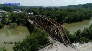
There's three major rivers that begin here and two of them after this rain had horrific flooding.
The other had almost no flooding.
So it really sort of explains how different conditions can change in the very small areas.
And, you know, I was in one of the watersheds at the Kentucky River that really devastated Whitesburg.
I'm from here in Jenkins, where the big Sandy devastated areas of Jenkins.
And although, you know, I can look outside until we're getting a tremendous amount of rain, you really didn't know what was coming or how severe this was going to be.
One of the issues with the mountains is we'll have a pop up storm that hits one part of town and then it may not even rain.
And the other part, it'll split the difference between two hollows and wash off the roads and it'll be dry.
Another Tampere.
Tampering.
JENKINS We have a gauge of power at the dam and it has a range on it.
And with that rain gives the rain gauge there and there's a range dunelm and there's also a range down here at the bird on school.
So we have rain gauges in different locations.
So you can kind of catch those events or something's going on.
I live close to a stream and should we pay attention to it?
And that's one of the things we want to do, is just people be aware.
And if they want to sign up for it and get on or they can understand, the bottom of the bridge is six foot.
And when the water gets to five foot, well, they've got a foot to think about.
This is not an emergency alert.
I do this right now.
I mean, it's not going to wake you up in the middle of that, but it's going to come up, say, okay, hey, the stream's up to here.
And if you understand, top of your creek bank is three foot.
Well, four foot, it's going to be up in the air a little bit.
So the numbers does not represent how deep the water is or even like it is just a number of gauge for that gauge.
And so we do have I have a hand out, has some stuff.
We have also a website called a Flood Impact Map that we have put things in and tells you where the top of the road level is, what that number is, top of the bank, you know, foundation of school down here, that type of stuff.
We have those.
Numbers now that these gauges are in place for me personally, it has reduced the anxiety of when heavy rains come because you can look at the numbers and go, oh, that was a tremendous amount of rain.
We just got.
But it was a small blip on the gauge compared to what you might see in a major flood event.
There are 250 stream gauges being used by the US Geological Survey in Kentucky and roughly 13,000 spread out through the rest of the country.

Artificial Intelligence Task Force
Video has Closed Captions
Clip: S3 Ep52 | 4m | Google representative speaks to members of Kentucky’s General Assembly about A.I. (4m)
Video has Closed Captions
Clip: S3 Ep52 | 3m 55s | Praise in northern Kentucky for house bill turned state law aimed at protecting children. (3m 55s)
Headlines Around Kentucky (8/13/2024)
Video has Closed Captions
Clip: S3 Ep52 | 3m 10s | A look at stories making headlines around the state. (3m 10s)
Providing Support for PBS.org
Learn Moreabout PBS online sponsorship
- News and Public Affairs

Top journalists deliver compelling original analysis of the hour's headlines.

- News and Public Affairs

FRONTLINE is investigative journalism that questions, explains and changes our world.


Support for PBS provided by:
Kentucky Edition is a local public television program presented by KET