What Made Last April’s High‑Risk Storm Unusual for Kentucky
Clip: Season 4 Episode 358 | 3m 18sVideo has Closed Captions
NWS explains why last April’s storm stood apart from other severe systems.
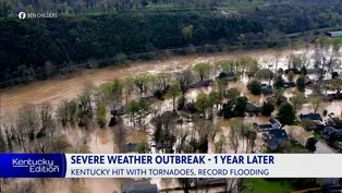
Last April's severe storms prompted the Storm Prediction Center to issue a rare "High Risk" designation for part of the state - the greatest threat level issued by the National Weather Service. Our Christie Dutton spoke with Michael Kochasic with the National Weather Service in Louisville about the storm and what made it different from other severe weather systems that have hit our state.
Problems playing video? | Closed Captioning Feedback
Problems playing video? | Closed Captioning Feedback
Kentucky Edition is a local public television program presented by KET
What Made Last April’s High‑Risk Storm Unusual for Kentucky
Clip: Season 4 Episode 358 | 3m 18sVideo has Closed Captions
Last April's severe storms prompted the Storm Prediction Center to issue a rare "High Risk" designation for part of the state - the greatest threat level issued by the National Weather Service. Our Christie Dutton spoke with Michael Kochasic with the National Weather Service in Louisville about the storm and what made it different from other severe weather systems that have hit our state.
Problems playing video? | Closed Captioning Feedback
How to Watch Kentucky Edition
Kentucky Edition is available to stream on pbs.org and the free PBS App, available on iPhone, Apple TV, Android TV, Android smartphones, Amazon Fire TV, Amazon Fire Tablet, Roku, Samsung Smart TV, LG TV, and Vizio.
Providing Support for PBS.org
Learn Moreabout PBS online sponsorship>> For Kentucky edition.
I'm Toby Gibbs.
>> The severe storms prompted the Storm Prediction Center to issue a rare high risk designation for part of the state, the greatest threat level issued by the National Weather Service.
I spoke with Michael SEEK with the National Weather Service in Louisville about the storm and what made it different from the other severe weather systems that have hit the state.
Michael, from the National Weather Service in Louisville is here with us.
So, Mike, you were talking about how this was a high risk event, and we knew it was because the Storm Prediction Center sent out a high risk for starters, just for the storms.
That could be severe.
Right?
>> Absolutely.
So the night of April 2nd, 2025, there was high risk in the western part of the state for severe weather, but there was also high risk later on through this event, later after April 2nd for rainfall.
So you had a lot of flooding rains.
You also had a lot of severe weather too.
>> Yeah.
Well, let's talk about the tornadoes.
1st April second, we had an EF three tornado in Louisville in the part of town we call J-town or Jeffersontown.
Talk about that tornado.
And, and you know why we sort of got lucky with it.
>> So that tornado was over nine miles long.
So not the whole thing was F3, but there was a spot in J-town right around the business park that it really intensified 145 mile an hour.
Winds were estimated there.
Extensive damage to the whole business park there.
And we got super lucky because it came through at night and there was nobody there that night.
So luckily no injuries to report, no fatalities, but still a very dangerous storm.
>> Absolutely.
And we had other F2 f one, several F1 tornadoes across the state.
But shortly after those strong storms came through, that rain started and it seemed like it just didn't let up for days.
We had historic flooding.
Talk about what we saw during that time.
>> When it rained cats and dogs.
We literally meant it.
I mean, several places had double digit of rainfall and it caused flooding all over the place.
But especially for Louisville too.
It was the eighth highest crest all time at the McAlpin Lock and Dam there, and just flooding all over the place.
Places that didn't typically flood flooded in that event.
>> Absolutely.
And even canceled Thunder over Louisville for the first time ever.
We had the highest record crest there along the Kentucky River near Camp Nelson, second highest in Frankfort.
And unfortunately, we had some deaths around the state from that flooding.
This was a multi-hazard event.
We had the severe storms, tornadoes first and then the flooding.
Are we seeing more of those multi-hazard thunderstorm events?
>> If you look at the period of record that we keep track of, we have normals every 30 years or so, and when you compare the previous normals of 30 year averages to the current ones that we're looking at now, Kentucky is getting warmer and wetter on average.
So with that, you see a lot more storms that are stronger, heavier rains, more wind, more lightning with them.
So just more severe all around.
So it's super important that you have a hazardous weather plan in place at home for multiple hazards when you're talking about wind and flooding.
>> That is great advice.
Michael from the National
Canine Follows Her Nose to Detect How Fire Starts
Video has Closed Captions
Clip: S4 Ep358 | 3m 10s | Meet the only ATF accelerant detection K-9 in the state of Kentucky. (3m 10s)
One Year After Severe Weather Outbreak
Video has Closed Captions
Clip: S4 Ep358 | 2m 46s | A look back at one of the most destructive spring weather events in Kentucky’s history. (2m 46s)

Program Gives Children a Place to Rest Their Heads
Video has Closed Captions
Clip: S4 Ep358 | 3m 11s | Student help build beds for children in need. (3m 11s)
Providing Support for PBS.org
Learn Moreabout PBS online sponsorship
- News and Public Affairs

Top journalists deliver compelling original analysis of the hour's headlines.

- News and Public Affairs

Today's top journalists discuss Washington's current political events and public affairs.


 New Season
Support for PBS provided by:
Kentucky Edition is a local public television program presented by KET