Winter Storm Brings Less Snow Than Expected, More Bitter Cold
Clip: Season 4 Episode 308 | 4m 10sVideo has Closed Captions
National Weather Service explains why the state got less snow than expected.
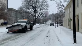
Some of the official snow and sleet accumulations from across the state are being reported by the National Weather Service. The totals vary from nearly 6 inches in Louisville and under 4 inches for Lexington and Bowling Green. Paducah reports just over 8 inches and Florence received almost 10 inches of snow. Forecasts predicted significantly higher snow totals than what fell in much of the state.
Problems playing video? | Closed Captioning Feedback
Problems playing video? | Closed Captioning Feedback
Kentucky Edition is a local public television program presented by KET
Winter Storm Brings Less Snow Than Expected, More Bitter Cold
Clip: Season 4 Episode 308 | 4m 10sVideo has Closed Captions
Some of the official snow and sleet accumulations from across the state are being reported by the National Weather Service. The totals vary from nearly 6 inches in Louisville and under 4 inches for Lexington and Bowling Green. Paducah reports just over 8 inches and Florence received almost 10 inches of snow. Forecasts predicted significantly higher snow totals than what fell in much of the state.
Problems playing video? | Closed Captioning Feedback
How to Watch Kentucky Edition
Kentucky Edition is available to stream on pbs.org and the free PBS App, available on iPhone, Apple TV, Android TV, Android smartphones, Amazon Fire TV, Amazon Fire Tablet, Roku, Samsung Smart TV, and Vizio.
Providing Support for PBS.org
Learn Moreabout PBS online sponsorshipWhile some of the official snow and sleet accumulations from across the state are being reported by the National Weather Service, the totals vary from nearly six inches in Louisville and under four inches for Lexington in Bowling Green.
Paducah reports just over eight inches, and Florence received almost ten inches of snow.
Forecast predicted significantly higher snow totals than what fell in much of the state.
Our Christine asked the National Weather Service meteorologist why we got less snow than expected, and what we need to do and know about the bitter cold weather settling in.
Michael Kocher with the National Weather Service joins us.
So, Michael, with these snow totals that we've seen, what have we seen across the state of Kentucky?
How much has it varied?
Absolutely.
So the forecast straight up was originally supposed to be 12 to 18in, mainly along the I-64 and I-71 corridors.
But we got sleet it.
And what happens is when you get more sleet, more ice, it kind of robs the moisture from the snow to kind of form.
So we saw lesser snow totals anywhere from 5 to 7in along the I-70 one corridor, at least around Louisville.
But as you get off to, Covington area, northern Kentucky, they saw a little more snow, a greater than eight.
But there was a lot of sleet, too.
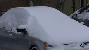
So it's a real heavy, wet snow because it was right around that freezing line.
So if you're outside shoveling, be careful because it's crusty and it's heavy.
Yeah.
And what about the freezing rain there?
For portions, a lot of people just got a complete glaze over of freezing rain.
Where was that?
The worst.
South central Kentucky, around Bowling Green.
It's a little bit to the east of Bowling Green.
Baron Monroe.
Allen County saw the worst, and then it went northeast towards Campbellsville all the way up to Ashland.
If you can imagine a line from Ashland, the Bowling green, we saw anywhere from at least half an inch to maybe even three quarters of an inch, some locally higher spots that up to an inch was reported.
So a lot of heavy ice there on power lines and trees.
It makes for a lot of slick conditions.
Oh yeah, that causes a lot of problems.
That much freezing rain.
So let's talk about shoveling snow.
You mentioned that.
So what do we need to watch out for?
Because I know a lot of people are heading outside to do that today.
Absolutely won't take it slow and easy.
A lot of folks, you know, are used to that kind of strenuous labor.
I believe we lost several folks in the January 2025.
We call it the ice sandwich, where it snowed, then ice and snow again.
People went outside and started shoveling and it was really heavy.
And you have a heart attack or you slip in trip and fall.
So just be careful.
Drink lots of water.
Take breaks and it's okay.
It'll get done eventually.
But, it doesn't have to be done all at once.
Yeah.
Okay.
And let's talk about this bitter cold weather we have right now.
We have an extreme cold warning in effect.
How cold is it going to get?
Well, we're talking about single digits, maybe even slightly below zero in some spots.
And then when you factor in a little bit of a wind chill with that, you're talking as low as -20°F, which is very, very cold.
You're talking a minimum of ten minutes if you're outside unprotected to frostbite or hypothermia.
Hypothermia.
Excuse me.
So you're talking about very, very cold temperatures, please.
Dress bundle warm.
And that way you're ready to go in case you're outside.
But try to avoid being outside as much as you can during the morning hours.
Yeah, and that applies to pets, too.
I know a lot of people have indoor outdoor pets.
So what do they need to know about this?
Well, if it's too cold for you, it's too cold for fluffy.
So please don't leave them outside for any long duration.
You know, periods that ten minutes of minimum time that could apply to them as well.
So try to remember your pets and bring them inside.
You know, that kind of thing and keep them protected.
Okay.
That is great.
Great advice.
Thank you so much.
We will try to stay warm and you do the same.
Very well.
Thanks for having us.
And thank you, Christy.
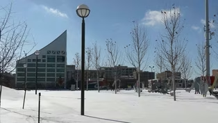
Temperatures will stay below freezing for the entire week across most of the state.
This will keep much of the snow and ice from melting.
Dangerous wind chill temperatures below zero will also last through tomorrow morning for most of Kentucky.

Crews Work to Restore Power in Southern Kentucky
Video has Closed Captions
Clip: S4 Ep308 | 4m 55s | Highest concentration of power outages in the southern region of the state. (4m 55s)
Icy Conditions Leads to Road Closures
Video has Closed Captions
Clip: S4 Ep308 | 3m 34s | Bowling Green-Warren County sees lane closures on interstate and main roads due to icy conditions. (3m 34s)
Louisville Remains Largely Shutdown Due to Winter Storm
Video has Closed Captions
Clip: S4 Ep308 | 2m 26s | Louisville officials give update on plans to fully reopen city. (2m 26s)
Northern Kentucky Sets Another Snowfall Record
Video has Closed Captions
Clip: S4 Ep308 | 3m | Northern Kentucky communities receive foot of snow, declare snow emergencies. (3m)
Providing Support for PBS.org
Learn Moreabout PBS online sponsorship
- News and Public Affairs

Top journalists deliver compelling original analysis of the hour's headlines.

- News and Public Affairs

FRONTLINE is investigative journalism that questions, explains and changes our world.


Support for PBS provided by:
Kentucky Edition is a local public television program presented by KET