Wrangell-St. Elias National Park: Wilderness of Ice, Salmon, and Human History
Season 9 Episode 904 | 26m 46sVideo has Closed Captions
Our largest national park has become an important natural laboratory.
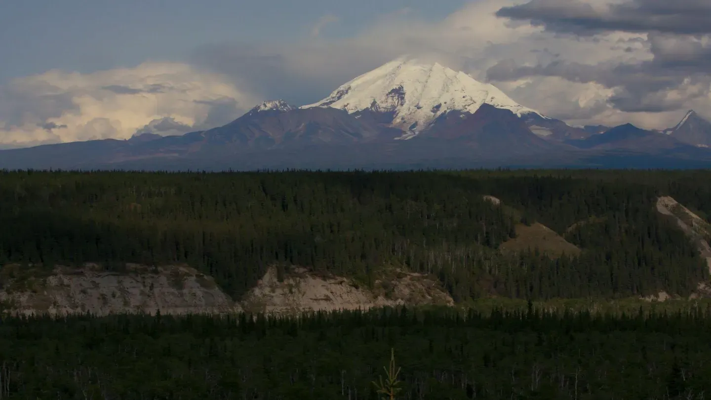
It’s our largest national park—larger than New England--and one-third of it is ice. One glacier is 137 miles long. The park contains active volcanoes. Its rivers of icemelt are home to salmon runs that have supported native peoples for thousands of years. Yet the glaciers are melting, and forests are drying. The park has become an enormously important natural laboratory.
Problems playing video? | Closed Captioning Feedback
Problems playing video? | Closed Captioning Feedback
In the Americas with David Yetman is presented by your local public television station.
Distributed nationally by American Public Television
Wrangell-St. Elias National Park: Wilderness of Ice, Salmon, and Human History
Season 9 Episode 904 | 26m 46sVideo has Closed Captions
It’s our largest national park—larger than New England--and one-third of it is ice. One glacier is 137 miles long. The park contains active volcanoes. Its rivers of icemelt are home to salmon runs that have supported native peoples for thousands of years. Yet the glaciers are melting, and forests are drying. The park has become an enormously important natural laboratory.
Problems playing video? | Closed Captioning Feedback
Where to Watch In the Americas with David Yetman
In the Americas with David Yetman is available to stream on pbs.org and the PBS app.
Providing Support for PBS.org
Learn Moreabout PBS online sponsorship(ice crunching) - [David] Our largest national park offers glaciers on a stupendous scale though, glaciers there are receding as they are all over the world you can still watch salmon runs in the glacier rivers and hike to your heart's content in Northern forests and on glacial ice.
(muffled speaking) This and more in Alaska's Wrangell St. Elias National Park.
(laid-back music) - [Narrator] Funding for In the Americas with David Yetman was provided by Agnese Haury.
Funding for In the Americas with David Yetman was also provided by the Guilford Fund.
(laid-back music) (laid-back music) (laid-back music) - Wrangell St. Elias is by far our largest national park.
It is located in Southeastern Alaska, near the panhandle.
It's a solid five hour drive East of Anchorage their state's capitol.
On the way to the park we passed the Matanuska Glacier.
It's outside the park, but still world-famous.
This part of Alaska and especially the park is home to active volcanoes rivers alive with salmon, rainforests and Arctic forests and Tundra.
It has a variety that's unmatched by any other park but most of all, it's well known and best known and internationally known for its glaciers.
(laid-back music) (jet zooming) - [Pilot] 3,500 square miles of glaciers in Wrangell St. Elias national park.
And the further West we get at this point we start to see more and more glaciers to the point where it becomes just a snow-cone type covered mass of ice out there.
(laid-back music) That's now the Chitina River we're going to be crossing.
Look how wide it is.
The water's gotta go somewhere.
Right now we're just comin' down to 5,800 feet, we're gonna climb up to about 8,000 feet as we come up over the ice fields, and the highest peak is over 18,000 in the March.
So that's quite a...
Rapid climb.
I can absolutely guarantee you that there's nobody in front of us until you get to the ocean maybe where there's a fishing vessel out there for a hundred miles in either direction.
It's just, it's hard to grasp the vastness of the wilderness up here.
When you think that the park itself is a size of New England, that gives a fairly good take on how much land there is here.
Bagley field.
Bagley Ice Field out there, huh?
It just goes to seemingly forever.
But of course, about 127 miles.
(laid-back music) Runnin' us off the ten o'clock position, the glacier, that's actually clear water, Dave, that reflects the color of the blue ice underneath that sometimes that pool of course turns into a erodes far enough into a mass, and then just disappears down into the glacier.
You know, the glacial ice is corrupted, the glacier steel as the rock surface.
Absolutely.
(mumbling) This is not an old worn-down mountain range.
These are young, still very rough, still rising.
And it's as if you can see the plates in action.
Now look at those crowned semi-circular beams of glacier.
I'm told those are like tree roots.
So they evidence how far that glacier's advanced at any, in a year.
This is a classic U-shaped valley.
The glacier was probably as high as we are.
And as it melted, as it went down, it became like a gigantic chisel, and with the power of several thousand feet of ice it pulled downward by gravity and took everything with it.
It created and left behind that view.
The carved landscape, the volcanic landscape, the picture of ice and volcanic action.
Unlike anything I've ever seen before.
Welcome back to McCarthy, folks.
(plane vrooming) - The water in the Matanuska river originates in the Matanuska glacier.
It stands out as shrill as any glacier possibly can in contrast with the dark background.
It's impressive, but old timers will tell you that it has vastly reduced in size.
U-shaped valleys are the sign of a long history of powerful glaciation.
Glaciers can be thousands of feet thick and powerful instruments of moving dirt.
As they move, they accommodate lots of that dirt.
And when they melt, they leave it wherever the melting takes place.
If we look at the size, we can see what are called lateral moraines those at the side, places where the glacier has dropped down and left a pile, almost a little mesa of dirt above.
Where the glacier ends is called a terminal moraine.
And if we see a large pile and the glacier has retreated up the valley, we know that that's how far it got before enough melt occurred to where it dropped its huge pile and then quit.
(laid-back music) Over eons melting glaciers have created the Copper River.
When glaciers melt, they also drop the sediments they carry, which is why in summer the river is silty.
(scraping) - [Woman] This is a fish wheel.
- [David] A fish wheel.
it's a wheel that captures fish.
- Exactly.
Because the Copper River is so full of silt that you can't really catch fish fishing wise this way.
The other method is dip netting where you put out a long net.
- [David] The current then downstream turns the wheel and it scoops into the upstream movement of the salmon.
- Exactly.
And every fish wheel you'll see in our area will be different.
Everyone just designs what they can.
And they, first of all, hope that they float.
Then they hope that they turn.
Then they hope that they catch fish.
- Up and down the river you see these wheels operating and they sort of remind you of oil barrows.
But it's apparently a design perhaps some indigenous parts but also, the Russians may have been involved, the Russians were here before anybody from the United States began to lay claim for it.
Salmon swim up river to spawn.
They're born way up river and they swim down and live in the ocean.
And then return here.
Just one.
So the ingenious part of this wheel is that the current rushing downhill, has a powerful current, turns the wheel but the fish are swimming uphill up river and they swim right into the wheel and get caught.
It turns out of the water, and then because of this diagonal design ingenious, diagonal design, it very gently flops him off onto the deck and the tilt, the angle makes them slide off into the catchment pond.
- If I have some in good shape, I'll be letting them go.
That's the beauty of the live box here.
We don't always keep all of our fish.
And often if there's a king salmon, we let those go as well.
These fish have come over 100 miles upstream.
These look very good.
So I'm letting these females go.
Our local community can operate fish wheels in the river even if they don't have land on the river.
And for either a state or federal permit, Alaska residents can request to use someone's fish wheel and operate on the river as well.
Our family is allowed to catch 500 fish in a summer.
And the fish wheel goes basically from June 1st, until mid, mid August, when the trees and logs start coming down and jamming them up.
We don't take all 500.
We take what we need for the winter and a little bit of the spring.
So we budget salmon so that we get about two, two fish to three fish a week through the winter.
A lot of that is preserved fresh in, by freezing.
And then the other part of that is preserved smoked.
He's fairly thin and fairly, fairly red.
Meaning he's older.
He's pretty feisty.
Although he's older, I'm going to let this one go as well.
- Well now, you're going to let them go because they look healthy but they're going to go another couple of hundred miles upstream.
They're going to spawn and then they're going to die.
So what's the point of letting him go?
- Ecology.
We need them to go spawn so we can have more fish for future years.
- You need the healthy ones to grow up and spawn.
- Yes.
- And the sicker ones you'll remove and you'll pull the herd.
- Yes.
- That's a very good idea.
- We have to monitor the wheel a minimum of every eight hours eight to 10 hours.
And so we go down three times a day in a 24 hour period and take the fish.
We do need to protect our resource and we want future years of salmon.
So as they go out to the ocean for seven years and come back, we want in seven years to have more fish for ourselves and future generations.
(splashing) If I fall in- - We'll call the coastguard.
- Don't come after me because the water is so full with silt it usually drags people under.
We are very fortunate that we were allowed to get salmon to eat for subsistence, the native culture this is a huge part of their lives.
I mean, that's how they've survived through thousands of years.
And we do take some of our smoking techniques from native culture.
And then another way that we preserve is with fanning as well.
And they've adopted that.
So it's like a trade of cultures out here of how we preserve our salmon, but very important to all of the local people.
Alaska natives have lived in the copper basin for thousands of years.
Right now, we're here in the traditional territory of the Ahtna people.
Salmon are a really important resource for them.
Today they harvest them using fish wheels, but in the past they would have harvested them using dip nets in fast-flowing glacial rivers, like the Copper, or put fences across a shallower stream and using a trap.
- [David] Frightfully cold here for in the winter.
It's 60 below.
So they had to know how to live through that, those long winter months.
- Their, the house is a semi-subterranean house.
Oftentimes they use caches below the ground.
Although you also see in this illustration an above the ground drawing rack.
- But that depression there, then something might... Be what I'm seeing over here.
- Yeah.
We're not entirely sure; this may have been a winter home site.
Beginning in the late 18th century there were exploration parties that came into the basin of non-natives and in various waves, there were gold miners and non-natives came to the area to trap the wildlife resources were also noted.
And hunting parties started to come into the area.
And so there's a tradition of guidance for hunting.
In addition to the gold mining there was a discovery of copper.
It's now called the Kennicott area in the early 19th century and so an industrial mine was developed on the edge of the Kennicott Glacier and a railroad came in to transport the ore to markets outside of Alaska.
And that railroad also helped facilitate non-native entry into the area.
The local Ahtna people, they didn't use the kind of copper ore that was mined at the Kennicott mine, but they would find copper nuggets.
And there's a history of finding copper nuggets in this area.
And they developed a technology for taking those copper nuggets and turning them into tools.
(laid-back music) - Wrangell Mount St. Elias national park is named for two huge mountain ranges.
Wrangell and Mount St. Elias.
The highest peak is Mount St. Elias which is over 18,000 feet.
The second highest peak in the United States the range itself is the second highest range in all of North America.
The Wrangell range is volcanic.
It originated in volcanic explosion, sometimes violent, such as we see here in this diorama.
The entire range is built up of layer after layer of volcanic ash, lava and rock that was emitted from the magna that came up from below.
(laid-back music) It's summertime here in the park.
It's called boreal forest or Northern forest covers untold millions of square miles across Alaska and Canada.
And it's a lovely time of year.
Perhaps six months from now the temperature may reach 60 below zero.
Winters here are tough.
Summers here are nice.
(laid-back music) The park is so vast that getting from one part to another may involve several hours of driving.
From the headquarters we drive deep into the interior and the glaciers.
Along the way we find graphic evidence of the flooding that occurs as the glacier melts.
We're at the confluence of the Chitina River, coming out of the east and the Wrangell mountains, and the Copper River coming out of the North and the Wrangell mountains that the river bed is very wide.
And a lot of it isn't very deep.
Well that's because these are all glacier sediments that have been carried down fine particles or sand, loam, even some silt, the current moves back and forth and creates this very wide river bed that doesn't have a lot of water in it, but it's very hard to cross.
And that's the nature of glacier downstream river beds.
(laid-back music) The former mining town of MacArthur lies at the end of the road, a couple of hours away.
100 years ago, it was at the edge of the enormous Kennicott Glacier.
(laid-back music) - The ice was here.
Right here... A few decades ago.
And after the ice pulled back a bit, this was a river bar.
There was a river flowing right here.
And, and it's only since the ice and the river retreated that there's been time for plants to grow.
And, and that's, that's a slow process but these fuzzy little white plants you see down here this is called Dryas drummondii.
It's one of the first plants to grow in a glacial landscape- - The pioneer plants will move in, but it's pretty bad soil, isn't it?
- What's happened in a glacier this big, that comes out of many different tributary glaciers that come together and join in the main valley is that the rock and gravel that falls off the mountain slopes onto the glacier surface way upstream gets carried downstream with the ice.
And as the ice melts away the rocks and debris that have fallen on the ice they don't melt away.
But if we drill down through it it's mostly ice.
Wrangell St. Elias is the biggest park in the country.
13 plus million acres.
We have over 3,000 glaciers.
Our glaciers are shrinking and they're actually shrinking faster than ever right now.
Over the last 50 years, roughly speaking, the glacier cover in the park has shrunk by about 5% which doesn't sound like a lot.
But when you have a park this big and you remove 5% of the ice it actually turns out to be a tremendous quantity.
That's a lot of ice that, that has been turned into seawater now.
(laid-back music) Kennicott is a copper town.
It's named for the Kennicott Glacier but copper was discovered in the early 1900s.
They started shipping it out in 1911.
And by 1938 this very high grade copper deposit had been played out and the mines closed.
But all those buildings that we see up there all that infrastructure is related to that.
- The Kennicott Glacier has retreated over such a great distance that we can only see it from a tributary we hike into, the colossal root glacier.
(laid-back music) - The copper's up in the mountains above this site.
This is not the mine per se- - Quite a way up.
- Way up there.
This is just the mill town.
They built it right on the edge of the glacier as low on the mountain side as they could.
The children that for instance, grew up in these cabins just before the mine closed in 1938, some of them are still alive and have returned in the last decade or so.
And one of the main memories that many of them have told us about that is kind of striking is that when they were in Kennicott and looked across the Valley they couldn't see those mountains on the other side in 1938 what they saw was the glacier rising up and obscuring the view of anything outside of that viewpoint right there.
It was just ice rising up from the town.
Roughly speaking we think it was about 300 feet higher right here, adjacent to town, 300 feet of ice that's melted away.
It's a marker of where the ice was 'cause they didn't want to go any higher than they had to.
And that's true all the way down the valley.
The railroad was tucked up right next to the glacier.
- [David] That's a lot of water down the river.
- Yes, it is.
When glaciers grow and shrink...
They do it at the bottom first.
As recently as 150 years ago the ice would have been very close to this trail.
And that's the reason all these spruce here are fairly small and young is because they've, they've only had an opportunity to grow since that ice retreated.
But if you look up the Hill Where the ice didn't reach in the little ice age... - Oh yeah.
The trees are a lot taller.
- Yeah, those are big, mature white spruce trees, at least big by local standards.
This massive glacier is probably just more or less an average glacier in Wrangell St. Elias national- - It's an average sensational spectacular phenomenon.
- It's like being an average Olympic athlete.
And just like with rivers and the tributary we're going to get on is the root glacier but just out in front of us, the two come together.
- I knew when you see that same strange almost Badlands landscape.
And so underneath that veneer is ice.
(ice crunching) As we get higher it looks wider up there, but wherever we go there's going to be some of this debris wherever we go.
(ice crunching) - The climate in particular...
It's hard to see when you're just looking at the weather, the weather, is it a hot day, a cold day, a rainy day, a snowy day.
We know that even in a stable climate the weather is a, is an unpredictable and noisy signal.
And to, to see through that signal and detect a long-term trend is really difficult because glaciers respond really slowly to climatic changes.
And, and so you don't really see the weather when you look at a glacier, you see the climate you really see that long-term trend.
And the shrinkage of these glaciers is one of the best ways that people who are struggling to understand climate change can see it with their own eyes.
- It's weird to have this crunchy sound.
We're actually breaking ice as we walk that has debris on top of it.
(ice crunching) - Well, now that you're up close, you can see that even what we call the white ice is dirty.
Just adjacent to us that's what we call the debris-covered ice.
(water flowing) These little streams here...
This is the melting glacier right here.
It's where it's happening.
Is at the surface, the top of this glacier, you know, from the bottom to nearly the top there's melt occurring right now.
And it's all making its way along the surface, just like these streams here, we call these supra glacial streams because they're on top of the ice.
(water flowing) Eventually all of these streams will access the bed.
The water will make it to the bottom of the ice and then come out in the Kennicott river.
So this is where it happens.
This is where a glacier melt occurs.
This is where sea level rise begins.
The water that's inundating the streets of Miami, Florida during high tides is coming from thousands or even maybe millions of little streams like this on the glaciers all over the world.
(laid-back music) (ice crunching) (laid-back music) - Only a decade or so ago the scene below me would have contained much more glacier than it does now.
And it would have extended much farther down into the Valley.
And that's true of glaciers throughout the world.
They are almost all of them receding.
(water flowing) The glaciers in Wrangell St. Elias national park are accessible to the public.
And I'm one of the lucky few who gets to walk on them.
They will be here for a goodly while.
And my recommendation is you come and see them...
While you can.
(laid-back music) Join us next time In the Americas with me, David Yetman.
(laid-back music) 50 years ago, Baja, California seemed an unknown and deserted place and the Gulf of California a Marine Wonderland of inexhaustible bounty.
Development and crowds arrived.
And now are quickly exhausting local resources and undermining the peninsula's ecological richness.
(boat engines humming) Now Mexicans are teaming up with international experts and fighting back.
- You know, this is a great place to see a nice clean exposure of the kind of material that the glacier is eroding and carrying downstream.
When we look around this landscape, mostly what we see of this stuff on the surface, because that's what people think of, boulders, gravel, but that's only because the lighter finer grain stuff has washed away because of rain.
Most of what the glaciers are eroding is this silt clay.
And that's why we have muddy rivers here.
(laid-back music) - [Narrator] Funding for In the Americas with David Yetman was provided by Agnes Haury.
Funding for In the Americas with David Yetman was also provided by the Guilford Fund.
(laid-back music) Copies of this and other episodes of In the Americas with David Yetman are available from the Southwest Center.
To order, call +1 800-937-8632.
Please mention the episode number and program title.
Please be sure to visit us at intheamericas.com or intheamericas.org.
(laid-back music)


Support for PBS provided by:
In the Americas with David Yetman is presented by your local public television station.
Distributed nationally by American Public Television