The Desert Speaks
Desolation Canyon River
Season 14 Episode 1409 | 26m 14sVideo has Closed Captions
Take a trip down the Green River in Utah and to Dinosaur National Monument.
Explore the best-known geographical feature of the Green River, the prehistoric creatures buried along its banks in Dinosaur National Monument. Venture through the appropriately named Desolation Canyon, some of the wildest, least inhabited areas remaining in the U.S. Learn how the Green River continues to be shaped by changes in the surrounding geology, vegetation and modern-day dams.
Problems playing video? | Closed Captioning Feedback
Problems playing video? | Closed Captioning Feedback
The Desert Speaks is presented by your local public television station.
This AZPM Original Production streams here because of viewer donations. Make a gift now and support its creation and let us know what you love about it! Even more episodes are available to stream with AZPM Passport.
The Desert Speaks
Desolation Canyon River
Season 14 Episode 1409 | 26m 14sVideo has Closed Captions
Explore the best-known geographical feature of the Green River, the prehistoric creatures buried along its banks in Dinosaur National Monument. Venture through the appropriately named Desolation Canyon, some of the wildest, least inhabited areas remaining in the U.S. Learn how the Green River continues to be shaped by changes in the surrounding geology, vegetation and modern-day dams.
Problems playing video? | Closed Captioning Feedback
Where to Watch The Desert Speaks
The Desert Speaks is available to stream on pbs.org and the PBS app.
Providing Support for PBS.org
Learn Moreabout PBS online sponsorshipThe creatures found in the desert along Utah's Green River vary from the immense and old to the minuscule, young and pesky.
They also represent past cultures and present thrill seekers.
All are a part of the journey through one of the most isolated places in the wild southwest.
Funding for the Desert Speaks was provided by Desert Program Partners.
A group of concerned viewers making a financial commitment to the education about and preservation of our desert areas.
♪ music ♪ The best known desert river in the United States is the Colorado, which means "red" in Spanish.
Geographers trace its origin not to the state of Colorado but to Wyoming.
There it emerges from the vast Wind River Range and flows south into the desert of Utah.
There it's called the Green River.
Joined by the silt laden Yampa River, the Green River flows through the wildest and most remote place within the continental United States.
It's as close as you can get to a river unchanged since the time of the first European settlers.
Our story begins where the wild river ends, at Flaming Gorge Dam in northeastern Utah.
The River between Echo Park and Dinosaur Monument and the confluence with the Colorado River in the middle of Canyon Lance National Park, is the most natural long segment of the river that remains.
This is the wildest, most free-flowing part of the modern Colorado River system.
Whether it's deserts, rivers or dinosaurs, my friend Yar Petryszyn knows them well.
This clay formation around here really looks like it must be full of dinosaur bones.
Not that kind of dinosaur bones.
No, not that kind of bones.
These look like either lakebed settlements, maybe the Chinle formation, or the Green here which is a tributary of the Colorado River, is fairly young when compared to the rocks that it's cutting through.
It was before you and I were born.
So they have a shuttle going into the quarry.
This is great.
Yeah, with somebody's fanciful imagination here.
Yeah, look at that, different dinosaurs.
Dinosaur National Monument is a national treasure of dinosaur bones and majestic river canyons.
When these layers were laid down, it wasn't desert.
It was much, much different.
They were probably getting a hundred inches of rain.
Right.
Yeah, kind of subtropical, a lot of vegetation, a lot of water around, because these sediments here with the mud stones and sand stones were put down on water.
Wow, look at that wall just filled with dinosaur bones.
Look at this.
Hundreds of 'em.
The first paleontologist in the region named Earl Douglas found out about the fossils reading the accounts of John Wesley Powell's trip down the Green River.
Earl has this nice hat on, looks like Indian Jones, see.
And he's got that neckerchief around him to keep the mosquitoes off.
This is what he says, "I put my left hand up on the canyon wall, I took my hat off, I brushed the sweat from my brown, I slowly looked to the left and one finger was on a small dinosaur tooth sticking out of the wall."
And he stepped back from the wall and he looked up.
Earl Douglas was here from 1909 'til 1923.
He discovered twelve different species of dinosaurs.
No quarry in the world comes anywhere near that.
He found seven complete or near complete skulls and no quarry in the world can touch that.
I mean if you find a little piece of a skull you're lucky, in your quarry.
He put together 20 complete or near complete dinosaurs.
And no quarry in the world can even come close to that.
He hit the jackpot here.
This monument was established because of its extraordinary remains of dinosaurs from the Jurassic period.
It's a tremendous concentration of large animals, 145, 150 million year old dinosaurs.
This looks like a humorous of one of the big plant eaters.
That's this bone right up in here.
But look at the size of it.
This was a large river channel.
It was here for a long time.
And actually the bones are preserved in several layers here that represent different flood events that probably took place over a period of several hundred years.
This looks like the femur, which is the upper leg bone.
You can tell looking at the wall that most of the skeletons are incomplete.
You'll see part of a limb here, part of a tail here, piece of a backbone and maybe a lot of isolated elements.
These probably dried out somewhere far up stream and then were re-deposited during a high water period.
A lot of the bones, long bones in particular, are lined up in a certain direction which indicates the direction of water movement at the time.
If you look at this sand stone, you have the fine grains of sand but also these little pebbles, which showed that sometimes that there were much greater.
Of course the Green River as we know it today didn't exist at the time of the dinosaurs.
It's a much younger river.
But it certainly helped expose this area to the point where we can find these things today.
Leaving Dinosaur National Monument, the Green River enters a series of long, open valleys before it narrows into deep canyons.
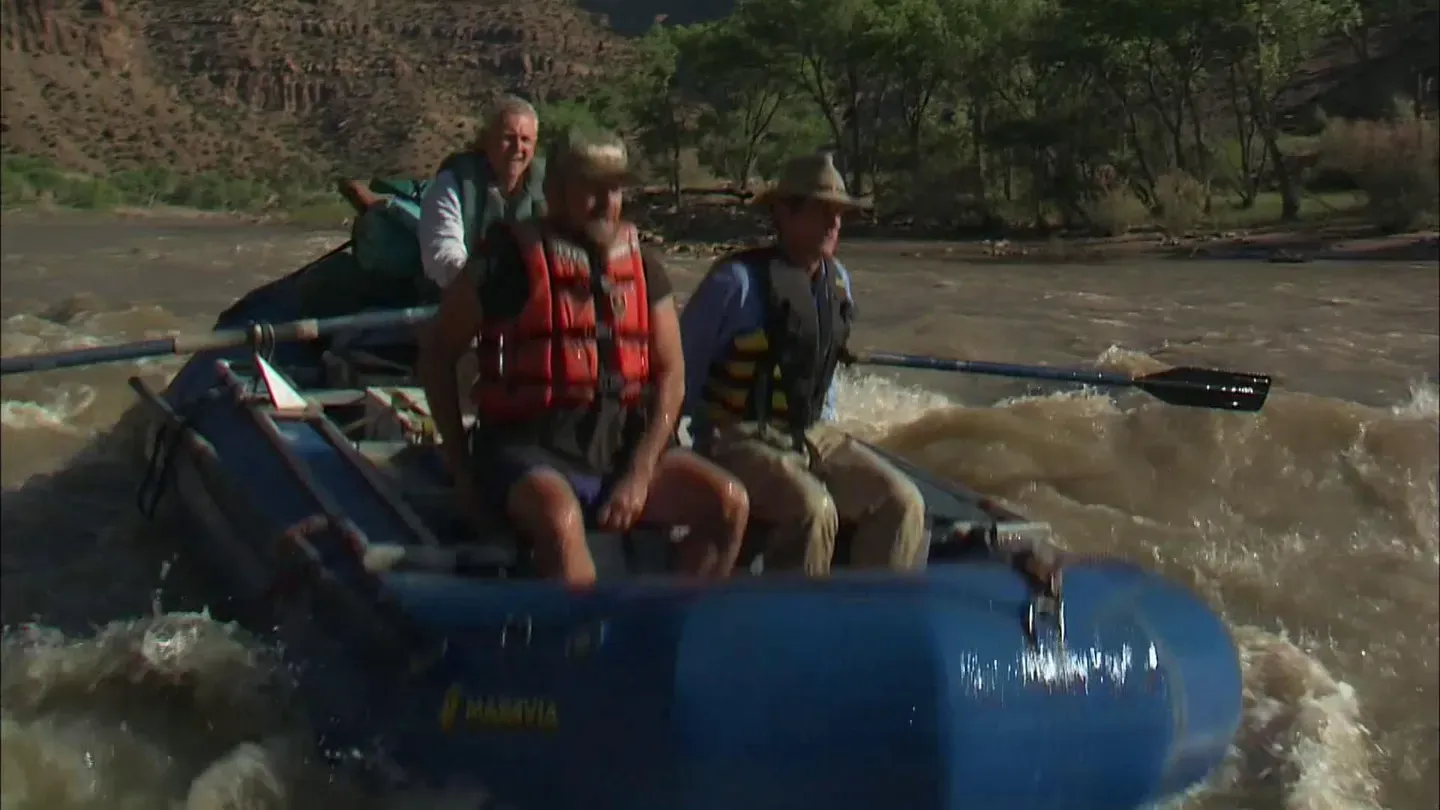
There we meet our friends to begin a river trip at the only accessible place for the next 100 miles.
People pay good money to be covered in mud like this at health spas.
Here you get it free.
You know when a cow gets stuck like that they just shoot him.
I'd be happy to accept that.
All right, Yar, let's see if I can get this foot out.
You're heard of the La Brea tar pits?
This makes them look like a Sunday School picnic.
Great mosquito year last year.
People'd show up in these things and I'd laugh at 'em.
They'd be wearing these things, there wouldn't be a mosquito in the air.
It's got a lot to do with high water, with the spike in the river.
Mosquitoes are terrible.
I mean, even mosquito repellant doesn't do much.
They are just clouds of 'em.
Hopefully once we get on the river in the current, we'll get away from 'em.
I'm gettin' weak from the loss of blood from the mosquitoes.
They haven't had malaria here on the Green River for at least five years.
At least.
All right, Jack, it's all yours.
All right.
John Wesley Powell came down the Green River of course in 1869 and the federal government has chosen to commemorate Desolation and Gray Canyon in his honor as a national historic monument.
So Desolation/Gray Canyon is a Powell National historic monument.
In honor of that our program is to try to protect it and maintain it as Powell saw it.
Did we just hit a wave?
We can talk about geology but every once in awhile we've got to pay attention to the fact that we're on a river.
There's rapids and there's riffles.
And this is really a riffle.
But for the Green River it's probably a rapid.
You are required to have a permit to be on this river.
We enforce that permit system and safeguard it, environmental safeguards, cultural safeguards.
We have a lot of cultural resources down here we have to look after.
We're not police officers.
That's the last thing I want to be.
And you don't really have to be because the users are so good.
I mean, they really are.
They've been here year after year, they understand, they want to preserve the place and we're just here to help 'em.
One reason for the Green River's inaccessibility is the lack of major side canyons that would allow visitors down to the river.
The few canyons that do exist were frequently used sometimes to great benefit.
This is the Ben Morris cabin in Firewater Canyon off the Green River.
It's a rock structure, hardly a cabin.
Ben was a moonshiner.
During prohibition, oh, and in the state of Utah, which was not known for its high rate of alcohol consumption.
These barrels were made out of oak and the hoops held the staves together.
You might call these hooch hoops and Ben's barrels.
Down river not too far there are a couple of ranches that grew fruit for their own families and of course they had a lot of extra fruit and they sold it to Ben who converted it into some pretty high power beverage.
The ranches had a lot of cowboys working for them and mine camps along the river as well as at the main ranch.
And they participated.
And there was a lot of traffic from the reservation and from Green River.
In fact, Green River as a railroad town supplied a lot of customers.
Ben married a woman named Josie Wales who lived quite a bit up river and Josie might or might not have killed a previous husband but when she was married to Ben she cooked for him.
And Ben made a very negative comment about Josie's gravy and she clobbered him over the head with a frying pan and that was the end of Ben and Josie's marriage.
Ellen, where did Ben ever get enough water to make that delicious hooch?
Well, he took advantage of a natural spring that follows a seam along this level of the canyon wall and he was able to collect enough here in this parched country to use for his moonshine still.
Just collect the drips and sooner or later that was enough to make a gallon a day or a couple gallons a year.
Exactly.
And there is his distillation mechanism, an old gas tank.
Green River is I think arguably the wildest, undesignated wilderness area in the lower 48 states.
It's a really wild place and it's so rugged it stays that way.
The only realistic way of getting out of this river is downstream in a boat.
John Wesley Powell and the Europeans since him were hardly the first people in the canyon, as he knew.
Do you suppose this was known throughout the area as the place to come for the artists to do their work?
Well, they're often associated with actual areas of use so this might have been a more sedentary place.
They might have farmed the bottom of Flat Canyon and by inhabiting a place longer they had more time to spend on rock art and more permanent structures.
I look at these petroglyphs as people's thoughts.
It's very hard to define what people were thinking but they were trying to express their thoughts.
And by having our own thoughts and the very human reaction of trying to decide what they meant, you enter a reverie of wonderful exploration trying to decide what they meant to the people then and what they're trying to say to us now.
I think you can safely say that they fall into the categories of meals, medicine and magic.
That has something to do with hunting perhaps and food, something to do with healing or illness or perhaps tragic events, and finally someway to address the supernatural.
So in those three broad categories you'd probably be on a safe track to interpret these petroglyphs.
So relative to the other canyons of the Colorado Plateau, these rocks are probably the youngest rocks that you go through in a deep canyon and it reminds us that the depths of these canyons and the narrowness of the canyons is not simply a function of the age of the rocks.
Because here we are in a canyon that's as deep as the Grand Canyon and yet these rocks are relatively young as a geologist thinks about them.
The dinosaur bones in Dinosaur National Monument are in rocks that are 150 million years.
But the rock here in the upper part of Desolation Canyon are much younger, 30 to 50 million years old and they were lakebed sediments.
So this used to be, at times, a huge lake but it also contained life.
And one of them is turtles, freshwater turtles that were found in these lakes.
They leave their imprints and fossils as well.
When you think about the Colorado River system, it's got three major tributaries, the Green River, the San Juan and the Upper Colorado in the state of Colorado.
This is the wildest, most natural, most free-flowing part of the modern Colorado River system.
The remarkable aspect of Desolation and Gray Canyons is how little it's changed.
The major changes here are associated with the invasion of riparian plants and a general narrowing of the river.
But by and large, where the rapids are, where the eddies are, where Powell Camp is, those places are all essentially the same.
The rapids that were the hardest in Powell's day are the rapids that are the hardest today.
We're having a much better time than they did.
We're eating much better food, we've got better boats, we know what we're doing, we've got great company.
Life is tough here on the river.
.chicken breasts and they are looking great.
The cornbread was made in a Dutch oven and it's really quite tasty, particularly after a desert rainstorm that chills the temperature maybe 30 degrees.
There's coleslaw and there's veggie burgers and there's chicken.
And after that there's an unnamed dessert, which will be a surprise that we don't know yet.
Camping is good stuff.
These large rivers geographers call them exotic rivers, exotic in the sense that the water in them has come from the Rocky Mountains, from somewhere else.
But the character of the river is determined by the fact that it goes through a desert landscape.
And in that sense these rivers of the Colorado Plateau have much in common with rivers like the Nile, which crosses a great desert.
And because the Yampa River is un-dammed, what we're looking at is a river system that essentially has one of its two arms affected or removed or controlled, but one of the arms is still the same free-flowing arm that's always been here.
So this river has had only part of its upstream watershed affected by dams.
This is supposed to be the Green River.
That is not green.
It looks more like the Colorado, which is supposed to be red in Spanish and I can't make sense of these colors.
Well, in the case of the Colorado, before the dams were built, there was a lot of sediments that were washed into the river and then actually at certain times of the year was actually quite red.
Mid-June, and the temperature today is supposed to be about 95.
The water, what do you think, Yar?
I'm guessing about 60 degrees.
That's a mighty cold 60.
I suppose, maybe.
I'm going to say 58.
But it is not warm.
The key element of these rivers as they flow through the deserts of southern and eastern Utah, is that large amounts of sediment are added to the water, which has had its origin in the Rocky Mountains.
But as the river then comes into the deserts of the northern Colorado Plateau, smaller streams, without much water, but with large sediment loads, bring that sand and silt and clay to the river and they give this river its unique characteristics.
And that's all related to the sediment that comes in from the desert regions of the Colorado Plateau.
All right, watch it here guys.
We're gonna get a little bit wet.
I have relative confidence in you to keep us out of the drink.
Hold on, here we go.
All right.
The river's gradient is really controlled by this inner play between coarse material down the tributaries and these large floods coming down the main stem.
Rock Creek Ranch was started by the Sea Mountain Brothers in the early 1900s and had a succession of owners up until the second World War.
From this ranch to the nearest town was about 50 miles and they had to go out on horseback with probably an empty pack train or a minimally packed pack train and then they'd bring in a full pack train.
And it's one of the most rugged trails in the region.
Just about everything came in on horseback and mule, not much was brought down the river.
The ranchers were a little bit intimidated by the big river so everything pretty much came down by land.
But they would pick the debris piles.
Lumber would come down in the current.
Actually, yeah, fir and pine probably coming.
Right.
We met one of the people who'd lived here, who actually grew up here and had spent most of his young life here.
And he spoke of how hard it was and yet in the 60s when he would come here, he would say it was the best time of his entire life.
Temperature ranges quite widely.
During the winter it's really cold here but then during the summer you can get into the high 90s at times, so quite a diverse range of temperature.
It's relatively dry here, probably rainfall varies depending on where you're at anywhere from eight inches to eleven or twelve inches.
After passing through the profound canyons of Desolation Canyon, we ease into the more open Gray Canyon.
In all fairness, shouldn't this be called the Yampa Green?
Every element of the wildness of this river is given to us by the Yampa.
Yeah.
And to some extent by the White River.
When Powell and his bunch came down, was it easier for them to get off the river to camp than it is now?
I mean, sometimes it's just hell getting off the river.
Well, today's river is lined by dense stands of tamarisk and willow and therefore much of the time when we flow today, we can't pull off anywhere because of these dense stands of brush.
Camping was easy for Powell.
This river was lined by rock and sand and the amount of riparian vegetation along the riverbanks was much less a hundred years ago than it is now.
The Grand Canyon has been changed dramatically by dams, places where there are reservoirs have obviously been completely changed.
But here where we have the wild Yampa River, we have the most similar feeling to the feelings that Powell had.
The water's still pretty cold.
You wanted wet, we've got wet.
Yeah, the water back then was much different.
It was warmer because you didn't have the dam.
Oh, so that cools it down.
Right.
But still the native fish here like humpback chub and suckers were really adapted actually to muddier water.
Fortunately for the native fish and for our purposes not all the dreams of dam builders have been successful.
It looks like somebody stood here in 1922 and snapped a picture.
And they took these photos of the river, they were looking for dam sites along the river and so we can look at this now and see how the river's changed.
So the river is much narrower now and the edges of the river are now covered with trees, young cottonwoods, willow and tamarisk.
Do you see that?
That whole thing, all this has moved out.
All of that's new.
And that's because of floods in the early part of this century were much higher than they are today and once those floods stopped occurring then the riparian vegetation came down and overgrew on these sandbars and gravel bars.
So the river is a narrower river today than when Powell went down.
Look at this mark, in 1917, that area was a bare gravel bar in June of '17.
And now that's completely inactive and covered by vegetation.
So long as the Yampa River remains a free-flowing, un-dammed, essentially un-diverted river, then this river in Desolation and Gray Canyons will remain as wild as it is.
If the Yampa River in the state of Colorado is someday diverted for large trans-basin diversions, then the fate of this river will be to transform it and further narrow it and lose its wild character.
Each year more visitors venture down the Green River than in the one hundred years following the Powell expedition.
River management people now tell us that the recreational use has reached its maximum.
With that kind of public adoration, the work of research scientists and a vast increase in public awareness of the Green River, it, just like the dinosaur bones in Dinosaur National Monument, will remain a wild and isolated place for generations to come.
Many Tohono O'odham continue to harvest, gather and plant in the Sonoran Desert just as they always have.
And now there is a sense of urgency to pass the traditional ways on to a new generation.
Next time on the Desert Speaks.
♪ music ♪ Funding for the Desert Speaks was provided by Desert Program Partners.
A group of concerned viewers making a financial commitment to the education about and preservation of our desert areas.

- Science and Nature

Explore scientific discoveries on television's most acclaimed science documentary series.

- Science and Nature

Capturing the splendor of the natural world, from the African plains to the Antarctic ice.


 New Season

 New Episode
 Recently Added


Support for PBS provided by:
The Desert Speaks is presented by your local public television station.
This AZPM Original Production streams here because of viewer donations. Make a gift now and support its creation and let us know what you love about it! Even more episodes are available to stream with AZPM Passport.