Historical Science
10/23/2025 | 26m 46sVideo has Closed Captions
Graveyard of the Atlantic, Indigenous peoples reconnect with a river and the oldest longleaf pine.
Learn what makes the Outer Banks so deadly and how the Coharie Indian Tribe’s restoration of their namesake river prompted a cultural awakening. Plus, botanists search for the world’s oldest longleaf pine.
Problems playing video? | Closed Captioning Feedback
Problems playing video? | Closed Captioning Feedback
SCI NC is a local public television program presented by PBS NC
Sci NC is supported by a generous bequest gift from Dan Carrigan and the Gaia Earth-Balance Endowment through the Gaston Community Foundation.
Historical Science
10/23/2025 | 26m 46sVideo has Closed Captions
Learn what makes the Outer Banks so deadly and how the Coharie Indian Tribe’s restoration of their namesake river prompted a cultural awakening. Plus, botanists search for the world’s oldest longleaf pine.
Problems playing video? | Closed Captioning Feedback
How to Watch SCI NC
SCI NC is available to stream on pbs.org and the free PBS App, available on iPhone, Apple TV, Android TV, Android smartphones, Amazon Fire TV, Amazon Fire Tablet, Roku, Samsung Smart TV, and Vizio.
Providing Support for PBS.org
Learn Moreabout PBS online sponsorship- Hi there, I'm Frank Graff.
The science behind why the Outer Banks are so dangerous.
Harnessing the power of indigenous knowledge to take care of a river.
And come along as we search for the oldest longleaf pine.
Dusting off historical science, next on SciNC.
- Quality public television is made possible through the financial contributions of viewers like you, who invite you to join them in supporting PBSNC.
Sci NC is supported by a generous bequest gift from Dan Carrigan and the Gaia Earth Balance Endowment through the Gaston Community Foundation.
(upbeat music) ♪ - Hi again and welcome to Sci NC.
The Outer Banks are known as the Graveyard of the Atlantic because of the number of shipwrecks off the coast and the storms that are on the area.
But what's behind the science behind the danger?
Our friends from Overview, an original show from PBS Digital Studios explain.
- Beneath this calm expanse lies a legacy of destruction.
Known as the graveyard of the Atlantic, this single area contains over 5,000 shipwrecks.
Each one a stark reminder of the ocean's immense power.
Among them is the wreckage of a ship that sank in 1718.
Its captain was the English pirate Blackbeard, another victim, one of the most perilous coastlines in the Western Hemisphere.
This is the Outer Banks, a chain of barrier islands stretching hundreds of miles along North Carolina's Atlantic coast.
And this is a shipwreck.
Remains of ships like this one, whatever it is, are a haunting testament to the power of the sea.
The Outer Banks is a living landscape.
The dynamically changing coastlines that unearth this shipwreck also make this one of the most destructive places on earth, not just for ships, but for those who still live here today.
(water splashing) Just like the great ships of the sea before them, these tides now threaten roads, oceanfront homes, the existence of entire communities.
But what is it about this little spot on the Atlantic that makes it so dangerous?
And could our changing planet make these waters even more dangerous?
(dramatic music) (waves crashing) I'm passing over Oregon Inlet.
It's named for a ship that narrowly escaped a powerful hurricane back in 1846.
That super storm tore through this barrier island, literally ripping it in two.
This inlet, like the rest of the Outer Banks, is constantly shifting.
These moving sands create treacherous navigational conditions and require constant dredging.
It's these rapidly changing features that make this coastline so dangerous.
These morphing shallows of sand and sediment are known as shoals.
Shoals form underwater as waves and currents slow down and lose energy and deposit sediment on the sea floor.
While shoals are a defining feature of the Outer Banks, they aren't all bad.
They provide critical habitats for marine life like fish, crabs, and migratory birds.
They act as nurseries for juvenile species and support complex food webs.
And they act as buffers between the Atlantic Ocean and the mainland by absorbing the brunt of storms and sea level rise.
The gentle slope of the Outer Banks continental shelf creates an ideal environment for shoals as sand is pushed from deeper waters up onto the shelf.
Wave and tidal action move sand in and out of these shallow areas, redistributing sediment and often elongating shoals into ridges or bars.
Adding to this mix is the warm, fast-moving Gulf Stream current that converges with the cold Labrador current off of Cape Hatteras.
This blends to create heavy turbulence and fluctuating water flow, depositing even more sediment.
This perfect storm of hydrology is what makes the Outer Banks so unpredictable and dangerous for navigation.
These forces are powerful enough to create entirely new islands and then destroy them.
Shelley Island sprang up suddenly in 2017.
At its peak size, it stretched over a kilometer and a half in length and over 150 meters in width.
After Hurricane Maria in late 2017, the island greatly diminished in size and in less than a year, it had vanished like a ghost back into the depths of the graveyard of the Atlantic as so many ships did before it.
Maritime history in this area goes back centuries.
Since the 1600s, sailors have used these waterways for fishing, trade, whaling, even warfare.
I'm on my way to meet up with a friend who knows a lot about this stuff.
A maritime historian, an archeologist, and host of PBS's "Rogue History," Joel Cook.
- Not far from here in Beaufort Inlet, Blackbeard and his crew, his two ships, are trying to evade the authorities.
They tend to sail smaller ships that have shallower drafts so they don't have to be in as deep water.
The Navy ships that are heavy battleships can't access these places where pirates can, and the shifting sands of North Carolina help them escape.
This ship that is known as the Terror of the Seas, you know, it's a legend already at this time period for Blackbeard.
The Queen Anne's Revenge ends up running aground in Beaufort Inlet, and he's forced to abandon it and some of his crew as well.
The ship itself stays there until it's found in 1996 by a team of investigators.
- The Outer Banks have long been infamous for their ties to piracy, but that's just a fraction of their shipwreck history.
These waters have swallowed everything from Spanish galleons to Civil War ironclads and World War II freighters.
To dive deeper into this incredible history, Joel and I head to the graveyard of the Atlantic Museum.
(upbeat music) How does this coastal region compare in terms of the number of shipwrecks to other places in the world?
- It really doesn't.
You have a count of shipwrecks that starts here in 1526, and from that time period until now, you have 5,000 shipwrecks in this little piece of North Carolina.
- So this is just on a completely different level from other coastal points in the world.
- It's unbelievable.
The USS Monitor, which is known as the first successful American ironclad, it wins a battle against the Confederate Merrimack, and it sinks close to here because of the conditions in this area.
At the tail end of World War I, the German Navy begins contributing to the graveyard of the Atlantic with their infamous U-boats, and the German Navy takes advantage of this by stationing U-boats around Cape Hatteras at a point that ends up being known as Torpedo Alley.
What they're able to do is use the lighting from the coastline in order to attack vessels because they can see the silhouettes of these ships using that light from the coastline.
These attacks continue into World War II, and though the US is aware of the German U-boats, they're not able to stop the onslaught of attacks on these convoys moving up and down the coast of North Carolina.
(beeping) - How much do you think is still out there waiting to be uncovered that we just don't even know about?
- I think there's tons.
If you consider those conditions haven't changed.
The weather's still rough here, the oceans are still rough here, so it's hard for people like me and other archaeologists to get out there and find every little thing.
Even in the sand dunes here where we have shipwrecks that are on shore, people find new stuff every year.
The sand dunes move, new shipwrecks are uncovered, others-- - A shipwreck that nobody knew about just emerging from the sand.
- Absolutely.
- Wow.
- But while this coast remains treacherous even to experienced sea captains and continues to claim ships to this day, there is a new danger, one that we have to view from above.
From the air, the Outer Banks is just a fragile sliver of land next to an endless sea.
You can see the scars left by storms, the shifting inlets, the way the island bends and reshapes itself at the mercy of the ocean.
The shifting coastline doesn't impact just seafarers.
The towns and beachfront homes that dot this picturesque coast are now threatened by the same forces.
These are homes literally being swallowed by the sea.
When these elevated houses were built, they were protected by stretches of dry sand and by dunes.
But a combination of wind and waves and tides have brought the sea literally to their doorstep.
When waves and currents approach the shoreline at an angle, sand and sediment are pushed up the beach in a zigzag pattern called longshore drift.
Over many years, this process can move entire beaches, putting homes in danger of literally falling into the sea.
Over the past four years, at least 17 homes have collapsed into the waves.
Since officials have been monitoring this area, this coastline has eroded by 10 to 15 feet per year.
And who knows, weeks, months from now, these houses will be reclaimed by the ocean.
This coastline has always been unstable and flood-prone, but climate change threatens to make it even more treacherous.
Storms and hurricanes that are more severe, along with rising sea levels, will have a major impact for the communities on the Outer Banks, in some places threatening their very existence.
Is it only a matter of time before these barrier islands become consumed by the sea?
Possibly.
- The shifting nature of the Outer Banks makes the land and sea difficult to predict.
Climate change and the effect that humans are having on our oceans and atmosphere only makes those challenges harder to deal with.
- Change is a constant on the Outer Banks.
Humans have sometimes failed to navigate that change, and the disastrous consequences are still visible beneath the waters.
It's a warning sign to future generations.
But today, as our actions change the planet as a whole, the survival of the communities and ecosystems that call this coastline home, that'll require more than just steering through the shifting sands.
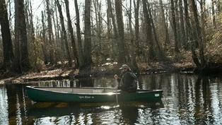
- The Great Coharie River in North Carolina's coastal plain has long been the lifeblood of the Coharie tribe.
It's provided food, transportation, and a spiritual connection.
But storms and development have taken their toll.
As part of our State of Change series, producer Michelle Lotker shows us how the tribe is reconnecting to the river and its effects on the community.
- I love this quote.
Can't remember where I got it from, but "Rivers never go in reverse."
You can apply that to your life.
Life is beautiful.
There's so many things to look forward to.
And I think that can kind of tie into the tight and windy path our river is, the braided channel.
That's how life is.
- The Great Coharie River is a braided stream in its headwaters.
And that means that the stream has multiple channels.
If you look at it from overhead, they sort of intertwine and weave in and out of one another.
That is a common characteristic of streams that flow through sandy areas like Samson County.
Here in the Southeast, climate change is making the water cycle more extreme.
In Eastern North Carolina, that is no exception.
Rivers like the Great Coharie are also subject to these extreme flows.
And we've seen this in recent years through floods that have come with hurricanes.
They've also had very intense droughts in the region.
Those swings between high and low create all kinds of challenges for people and for the river itself.
- The Great Coharie River Initiative started with a simple premise of just gaining access to the Great Coharie River here in Coharie Land.
The land down south of here, on the other side of Clinton, the water systems down there, they're open, the river flows free.
But up here, it was clogged with debris.
- The storms had downed trees.
The overpopulation of beavers had dammed up the run.
The water wasn't flowing.
It was backing up on agricultural soil.
- From the perspective of Coharie people, a healthy river is one that has constant interaction with people through paddling, through fishing, through swimming, and just being close to the river.
And because the river was closed off to them for so many years, it had devolved into an unhealthy state.
And so one of the early aims of the Great Coharie River Initiative was to clear a path through the river channels so that people could once again paddle this beautiful blackwater stream.
- The crew that we used or talked in to help us was our drum team.
We just asked them, "Look, can y'all come help us Saturday, clean out a section of the river?
And it's just gonna be dirty and nasty, but we'll have a good time.
We could feed you, but that's all we could offer you."
The first three or four Saturdays that we worked, we cleaned out probably about a mile of river.
Out of those eight young men, the first day we started, there was only one that had a full-time job.
And what I noticed about that same group, the second year when they came back, there was only one person that didn't have a job.
So we saw something that came alive there that made a difference in a group of young men in our community.
- I'm not so sure that we've helped that river as much as it has helped us.
This awakening that's taken place, it's come into our community.
So many more people participating, so many more people being responsible.
We know the importance, and that's gonna be passed down from generation to generation to generation.
- The greatest change that I've seen has been in our young folks.
The drum team has gotten bigger.
We have culture classes here now.
We have younger folks that have grown up through this Great Cohariee River Initiative era who are participants in those classes.
(drums beating) - This canoe here that we have in our museum is 600 years old.
And as we have turned to our responsibility of debris removal in the rivers of Sampson County, it was found over in South River.
So in my mind, it's like we're being responsible.
Now we're being the people that we should be.
And maybe it's proud of us.
So it decided to show its face and come back to this cultural revival.
(singing in native language) Colin is one of our best examples that got away, away from home.
But once he was introduced back into that, something spoke to him that changed him forever.
Now you can't get him to stop.
Something that was lying dormant inside of him, that river tapped into it and it sprang up.
- I'm gonna go way back.
I was born in 1993.
Growing up, I remember hearing stories from my grandpa, my dad about fishing down in our water, the Dannel Hole, which is actually Mr.
Phillip Bell's dad's, my great uncle, Dannel Bell.
And it's where a lot of food source came from for our people.
The first time I was introduced to the waterway was around 2015, 2016.
And I was like, this is insane.
This natural resource in my backyard that I wasn't able to enjoy as a kid.
Then when I got more involved and we created the Cohariee River Tours, it just helped me slow down.
I was living in Wilmington, North Carolina, and that's a fast paced life.
Just helped me slow down.
And helped me, when I'm out here on the river, think about what's important and what I want in life and thinking of legacy and what you can do for your community.
I wasn't very involved in the culture growing up.
Once I got involved with the river, I remember I went to my first drum class.
Just remember that first time drumming with all, mostly family members, that feeling I got from it.
I've never been able to put a finger to it.
It was just a good feeling.
- Cohariee and Lumbee and many other indigenous peoples in the Southeast especially, share names with rivers.
That is how our people identify.
Our rivers have a very strong spiritual and historical connection that involves their role in protecting us during early waves of colonization.
- When I go down that river, I can imagine my ancestors looking for a place, a belonging, a place that was safe that they could raise their families.
I can feel people doing whatever they got to do to survive.
But the beautiful thing is that I can feel the satisfaction of when they came to the Cohariee River.
Here's where we stopped running.
So here it is, 2025, and we're still on the banks of the Cohariee River.
It bears our name and we love it and we're gonna take care of it.
- Indigenous peoples are observers of their environment and they have been since time immemorial.
They are scientists, technicians, philosophers, and they carry this deep knowledge.
It's not always recognized in the ways that we recognize it in academic spaces, but that doesn't make it any less valuable.
The story of the Great Cohariee River Initiative is important because it shows how indigenous peoples can not only take the stewardship of the environment into their own hands, but when they do, amazing things can happen.
You can have healthy ecosystems, you can have people who are learning what it means to be in close relationship with water.
- It doesn't have the same uses as it did to our ancestors, but it's still important to keep it maintained.
And I have tons of ideas on more of like your 10 to 15 year plans on what this place could look like with proper care.
- That's pretty.
The longleaf pine ecosystem used to cover the entire Southeast United States, but logging and development have greatly reduced it.
Where trees are left though, it is still a vibrant ecosystem.
So let's continue our forest walk series now with a search for the oldest longleaf pine.
- This used to be a sand dune.
Do you mean the kind of sand dunes that we would have at the beach?
- Except much bigger.
And these sand dunes formed hundreds of thousands of years ago.
Goes back to the Appalachian mountains, carried here by little streams just like this, and rivers carrying mountains worth of sand.
- Those mountains worth of sand Andy's talking about were once mountains of stone ground down into sand and transported by wind, water, and time.
And it's still happening.
I wouldn't have expected to find a stream bisecting our path in what has been so far a dry sandy walk.
Now it's dark and damp.
(soft music) - And the tannin is basically the natural pigment found in all plant parts, which is decomposed organic matter, leaves, stems, branches, from hundreds of years of plant generations dumping leaves into here.
- It's the result of eons, literally hundreds of thousands of years, ancient dirt.
That stream is cutting through thousands and thousands of years of soil, sand mostly, that's been deposited here over tens of thousands of years.
- How would you describe this?
- Well, what we just came through was bottom land hardwood swamp.
Now we're stepping back up because that creek has carved a V-shaped channel through this ecosystem.
We've got pines on the high bank and then these mid-level hardwood forest mixed with pines.
And then in the very bottom, cypress, tulip poplar, and other trees that are keenly adapted to living in saturated soil.
- As we leave the bottom land swamp to climb back up to the pine forest, we pass through mid-level hardwood forest mixed with pine, where we see a small herd of white-tailed deer.
It's a sighting we could have easily predicted given our location, but I never get used to their striking beauty.
- These are pretty common, but they're not mundane.
- It takes my breath away.
And it's never just an average, "Oh, there's some deer."
- That's to the good.
- We continue on our way to the oldest known longleaf pine tree.
(gentle music) At nearly 500 years old, it sounds primordial, especially after seeing these deer, who won't live more than a few more years in the wild.
But this tree is still a youngster next to the dirt and sand washed down from the mountains over millennia.
This is it.
- That's it.
- This is it.
Look at this.
I mean, it... - Beyond stunning.
- Even the bark looks so much older.
We note the gnarled branches, markedly different from most of the other longleafs we've seen on this hike.
- So this is kind of a timeline.
Starting here, you're looking back 470 plus years.
And as you go up, you're looking back lesser and lesser time till you get to the top present day.
- So that means it would have germinated when?
- 1548.
Scientists have ring-corded to age the tree.
- That's just stunning.
So we're talking about land that would have been Native American land.
- Absolutely.
- Lumbee, Tuscarora.
I mean, you just think about what human life would have been like back then.
- And imagine when they were clearing all of this land around the Sandhills and North Carolina, it was all being done by enslaved Africans.
(soft music) It provides ecosystem services.
- Yep.
It's cleaning our air, filtering our water, cycling our water from ground up into the clouds that rain down somewhere else with precipitation that benefits a farmer a hundred miles away.
So the whole point of this trip is if the farmer feels frustrated one day, wants to take a hike, here's a place to come and give thanks to a tree that's helping everybody for free.
- Thank you.
- Our human perception of time and space is tiny when held up against the history of the world.
Hard for humans to comprehend because it's so much vaster than the way we mark time in hours, days, weeks, even years.
(soft music) And I'm Frank Graff, thanks for watching.
(soft music) - Sci NC is supported by a generous bequest gift from Dan Carrigan and the Gaia Earth Balance Endowment through the Gaston Community Foundation.
- Quality public television is made possible through the financial contributions of viewers like you who invite you to join them in supporting PBSNC.
(soft music) ♪
Video has Closed Captions
Graveyard of the Atlantic, Indigenous peoples reconnect with a river and the oldest longleaf pine. (20s)
Providing Support for PBS.org
Learn Moreabout PBS online sponsorship
- Science and Nature

Explore scientific discoveries on television's most acclaimed science documentary series.

- Science and Nature

Capturing the splendor of the natural world, from the African plains to the Antarctic ice.


Support for PBS provided by:
SCI NC is a local public television program presented by PBS NC
Sci NC is supported by a generous bequest gift from Dan Carrigan and the Gaia Earth-Balance Endowment through the Gaston Community Foundation.