Putting Kentucky on the Map, Henry Faulkner, Lexington’s Main Street
Season 31 Episode 17 | 26m 40sVideo has Closed Captions
Explore the history of mapmaking in Kentucky, artist Henry Faulkner and Lexington's Main Street.
Explore the history of mapmaking in Kentucky; learn how artist and poet Henry Faulkner's upbringing in Kentucky influenced his life and work; and take a tour of Lexington's Main Street to discover the buildings and objects that tell the city's history.
Problems playing video? | Closed Captioning Feedback
Problems playing video? | Closed Captioning Feedback
Kentucky Life is a local public television program presented by KET
You give every Kentuckian the opportunity to explore new ideas and new worlds through KET. Visit the Kentucky Life website.
Putting Kentucky on the Map, Henry Faulkner, Lexington’s Main Street
Season 31 Episode 17 | 26m 40sVideo has Closed Captions
Explore the history of mapmaking in Kentucky; learn how artist and poet Henry Faulkner's upbringing in Kentucky influenced his life and work; and take a tour of Lexington's Main Street to discover the buildings and objects that tell the city's history.
Problems playing video? | Closed Captioning Feedback
Where to Watch Kentucky Life
Kentucky Life is available to stream on pbs.org and the PBS app.
Providing Support for PBS.org
Learn Moreabout PBS online sponsorshipby the KET Millennium Fund.
Coming up on Kentucky Life, we'll explore how what were once hand-drawn charts have evolved into the maps of Kentucky we now use today.
We'll meet one of the more colorful icons to ever call our state home, Henry Faulkner.
We'll check out the setting for this week's show Cumberland Gap National Historical Park.
And we'll discover the two-and-a-half centuries of history that occurred on a single street in Lexington.
All that's next on Kentucky Life.
[music playing] Hey, folks, and welcome to Kentucky Life.
I'm your host, Chip Polston.
It's good to see you again.
Our show this week has brought us to a simple V-shaped gap in the Appalachian Mountains.
But the significance of the site in the history of not just Kentucky, but America, cannot be understated.
This is the Cumberland Gap.
We're right at the point where Kentucky, Tennessee, and Virginia come together.
Just months before America declared its independence in 1776, Daniel Boone arrived in the region leading a company who set out to widen the path through the gap to make settlement of Kentucky and Tennessee easier.
Now, those early settlers didn't just stop in this area, though.
They continued to push westward in search of the American Dream of land and a new beginning.
How monumental was this in the creation of our nation?
According to the National Park Service, an estimated 47 million people in the United States are descendants of those early travelers.
It's a beautiful site, and we look forward to sharing more of it with you during our show.
But first, the Kentucky we know today wasn't always so clearly defined.
It had to be mapped one line at a time.
From early trails and hand-drawn charts to today's digital tools, each map has helped shape how we understand the land.
Let's explore how the Commonwealth was drawn and redrawn over time.
[music playing] We have a very rich history when it comes to mapping, and there's a lot of people, I think, that aren't aware of that.
Folks really take maps for granted.
We've all got them on our phones.
We've got them on screens now.
But I don't think people really understand what goes into making those maps, where that information comes from, and how it impacts their lives.
To understand how Kentucky got her maps, we have to go back to an era when this land was being shaped by the knowledge and movement of Indigenous Peoples.
The trails that the Native people carved through Kentucky are the highways that folks like Daniel Boone will follow.
They become the foundation of what somebody, a mapmaker like John Filson, for example, in the 1780s is going to use.
And it's no surprise then that you see so many of those Native traces and trails on his map that he produces alongside the evidence of early Kentucky settlement.
[music playing] Filson is really important because he puts Kentucky on the map internationally.
And that really establishes Kentucky as the place on the earliest American frontier.
And you look at that map, and it is so incredibly detailed and rich.
This is why it's such an iconic piece, and I think struck so many people both then and subsequently as just beautiful art.
Yeah, cartography is an art.
There is an art to making a map.
There is an art to making it consumable, usable.
To make a great map that really communicates what you're trying to get across take some special skills, take some special eyes.
Mapping Kentucky is a physically demanding activity.
And that really doesn't change until the turn of the 20th century and arguably still going on today.
You have to physically traverse every inch of it.
It's absolutely incredible when you look at the surveying output of some of these early Kentuckians, who are walking over hundreds of miles and laying out huge tracks of land for the benefit of folks over across the mountain in Virginia.
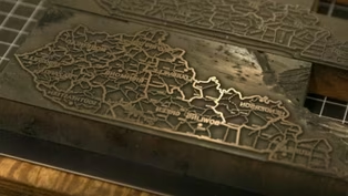
[music playing] Then they're going to ship that information along with copious notes to an engraver in Philadelphia who's going to carve that into usually a stone and then cover that with ink.
And then, they're going to prepare that for printing.
[music playing] Thinking about the Barker maps, I have to think specifically to the one that we have in the Filson collection, which has been cut up and glued down onto a really heavy cloth backing as a travel map.
[music playing] Without knowing precisely who owned this map, there are just so many little hand annotations that I think tell us so much about the growth of Kentucky here.
So, we see cities that are being put on the map in ink as they're being established, right?
Cincinnati, Maysville, think about the intellectual labor that's gone into the surveys of the creeks and the rivers.
Locating the cities and the forts, the trading posts, but then also recognizing that as valuable as this map as a production is, its information is finite and it constantly needs to be updated.
This is a working tool for somebody that's going out and doing those surveys.
It's such an incredible story about the settlement of Kentucky right here.
The maps that we start to see produced at a scale that it really is unimaginable to us are mapping as the story of individual families claiming space and land here.
In the 1800s, they did start producing a lot of the larger scale maps like the Sanborn maps and stuff that are kind of showing individual buildings.
So, the measurements are all very accurate.
The widths of the streets are all kind of accurate.
While accuracy was increasingly becoming the focus of map making during the late 1800s, there was another style of map quickly gaining popularity, the bird's-eye view.
[music playing] They were maps that were basically promotional things for the cities.
Definitely more artsy than accurate.
Somewhat like aerial photography it's a snapshot in time.
And if you go back and you look at those old historic maps, the one of Bowling Green with the reservoir up on the hill or the one of downtown Frankfort that showed what Frankfort looked like before they tore down a whole neighborhood to put in the new transportation cabinet building.
They may be just a pretty picture, but there's information there.
[music playing] You know, of the 20th century maps, the ones that I tend to find myself using the most are tourist maps, especially as we move into the era of establishing state parks in the 1920s, 1930s.
As we start to build more highways, tourism and culture become a huge selling point for Kentucky.
They have these wonderful iconographic representations of what it is to be Kentucky.
By the mid-20th century, mapping in Kentucky entered a new phase.
Through a coordinated effort between the United States Geological Survey and the Kentucky Geological Survey, the entire state was systematically mapped using 7.5-minute topographic quadrangles, which show intricate details like elevation contours, rivers and roads, making Kentucky the first state in the nation to be mapped at this level of precision.
Those maps, they really became the gospel.
That was the authoritative map that everybody goes to.
We kind of became known as the best mapped state in the nation.
[music playing] LiDAR is light detection and ranging.
It's like a big scan of everything in the built-in natural environment.
Super dense sampling, so we can create elevation layers that have been more accurate than they've ever been before.
Kentucky was one of the first states in the nation to complete a Phase I LiDAR acquisition, and in 2024, we completed our second statewide acquisition.
[music playing] Most aerial photography is nadir, top-down view.
You're looking at the top of a roof.
But with obliques, there's also a sensor looking forward, backward, and to each side.
So, what you end up with is, is you end up with a view of every piece of ground in Kentucky from all four cardinal directions.
We may be first in the nation to get this, but if we don't keep it up to date, then it's a one and done thing.
Kentucky has now been mapped to a precision of three inches, an unprecedented level of detail, and highlights how far we've come since early surveyors and cartographers drew those first maps of the Commonwealth.
[music playing] Lexington has long been a city of vivid personalities.
From Belle Brezing to Adolph Rupp, the city is home to figures who defied expectations and left their mark on its history.
Among them was one man who didn't just stand out.
He stood up for a community that did not have a voice.
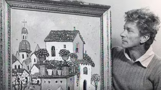
Let's meet Henry Faulkner.
Henry would tell me stories that sometimes, as a youngster, I thought, “Well, I'll bet that's not true.” But I eventually found out that everything Henry ever told me, for the most part, was true.
So, Henry Faulkner is probably amongst the most well-respected of Kentucky's artists.
So, known for his lively compositions, his paintings.
But of course, if you talk to anyone, if you ask anyone about Henry, of course, they're gonna talk about his artwork.
But almost immediately, they're gonna talk about Henry as a person, who Henry was.
Lively, vibrant, more so than even his beautiful use of color in his paintings.
He's born in Southern Kentucky to an agricultural, fairly poor family.
Quite large.
His mother dies when he's just a little boy.
And then, his father, the younger children, he sends off to the orphan home.
And eventually, it is the Whittemores in Clay County in Eastern Kentucky who become Henry's adoptive parents.
So, he is raised in Clay County.
He's raised in the mountains of Eastern Kentucky.
That is where he, of course, has some of his first experiences with drawing, painting.
Henry would sneak off to the woods and paint and create art out of mud and clay.
And he would hide his art.
He was kind of an outcast.
He stayed in trouble as a youth.
He was a vagabond.
You'll find him leaving Clay County pretty early on.
And he becomes somewhat itinerant for most of his young adulthood.
I mean, he's everywhere.
It's kinda hard to keep track of him.
As he starts to enter his teen years, he starts to run away.
We know he's going to Key West.
We know he's going to San Francisco.
We know he's going to Los Angeles.
In the late ‘40s, right after World War II, he's in New York.
And there, he is mostly hanging out with artists.
Henry is entering this world pretty early on as a young man.
And he wanted to be a poet.
He wanted to be a writer.
And he was both indeed.
Early work was drawing sketches.
And that was the era where abstract expression dominated.
And he felt the movement in his mind.
And he got a break in a consignment gallery.
And they sold a couple pieces of Henry's art.
And there was no looking back.
When he's in Florida, he gets a gallery show there.
And he meets who will be one of his most prominent early patrons, and that's Alice DeLamar.
She was a wealthy heiress.
It will be Alice who sends Henry to Europe for the first time.
And to Taormina, Sicily, in particular.
When he went to Taormina, it fueled and rocketed his color palettes, his imagination.
There was a way he mixed color that nobody can duplicate.
Henry's spirit is in the compositions.
Henry could turn out a whole lot of paintings very quickly.
He wanted to swing and splash the colors.
Henry's spontaneity was deeper than you can imagine.
Henry was before his time in many ways.
He did settle in Lexington.
And certainly, a character about the streets.
And everybody knew Henry and his goat Alice.
And wherever Henry was, there was a commotion.
It seems as though he becomes more consistent in terms of spending time in Lexington in 1955.
So, his life has gone through some of the darkest chapters he'll experience.
He was an openly gay man in a time when it was extraordinarily dangerous and of course illegal to be so.
And a huge advocate for freedom of expression, freedom of sexuality.
He was incarcerated in St.
Elizabeth in Washington, D.C.
for his homosexuality.
It was punishable in those days.
He preached about the gay community and did not shy away from that topic at a time when it was not real acceptable.
He really felt like he could change the world.
And Henry knew Tennessee Williams.
Tennessee took a lot of joy in being inspired by Henry.
Tennessee wrote books of poetry as well.
Henry would take him places in his mind that he was unable to go.
He would be inspired by Henry's stories and Henry's poetry.
He frequently would depict poems in the paintings.
If you read Henry's poetry, there's some very dark poetry as well.
There were dark places that Henry went in his life that never escaped Henry his entire life.
By the end of his life, he was very tired because he had lived a lean and rugged, often tormented existence.
Henry came back and was in Lexington in ‘80 and '81.
And that's when he died in a fiery car crash there at Broadway.
And it was a huge shock.
So, what does Henry mean in the future?
He means not to go away.
He means to have his presence emboldened and blazed and burning brightly.
Henry's story is extraordinarily important, I think, in a few ways, despite the many ways that a society would try to sort of knock that out of him.
And boy, they tried really, really hard.
Despite all of this, he creates this thing of beauty.
And this thing of beauty, I think, is his life.
Henry is and was a cultural icon of Kentucky.
That encompasses more than just being a painter, a radical politician, and a gay man.
There were these eccentric characters who went against the grain, who survived and triumphed.
And even in their demise, the revitalization of their story in their biographies is triumph.
He was a fighter for individual rights and freedoms.
He was a passionate lover of art and nature.
And he was a spiritual man.
He lived a life in often a spiritual war, hoping and praying that good would prevail.
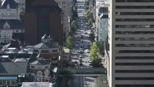
[music playing] One thing most cities across our nation have in common is a main street indeed named Main Street.
Lexington is no different.
Now, Lexington has a history that stretches back two and a half centuries.
A history that visitors and citizens can observe as they take a stroll down Main Street.
[music playing] [music playing] In 1780, the founders of Lexington, Kentucky, began to expand beyond the walls of their fort to build a city.
Eventually, streets were drawn up to divide the land, centering around one street, Main Street.
Little did the founders dream of a future where more than two centuries of Lexington's history would line this street.
Main Street today immediately greets visitors with the park testifying to the city's claim as horse capital of the world.
Thoroughbred Park is a representation of early Lexington when horse owners challenged each other to races down city streets.
These bronze statues designed by Gwen Reardon display the excitement of horses rushing for the finish line.
Along much of Main Street, visitors will find many more statues testifying to Lexington's love for the horse.
Just down the block from Thoroughbred Park is a reminder of another era for the city's history.
Great construction of Lexington renovated the Wolf Wile Department Store for its headquarters, but the Wolf Wile name on the building still remains today.
For decades, people from Lexington, Fayette County, and beyond would travel downtown to shop at large department stores like Wolf Wile, Purcell's, Woolworth's, and Ben Snyder's.
At Christmas, the streets would fill with families dreaming of gifts to come long before the age of malls began.
Near great construction stands a Lexington treasure, the Kentucky Theatre.
This movie theater opened in 1907 to great fanfare, and the beautiful sconces and chandeliers that have welcomed film aficionados through the years welcome moviegoers today.
The block of buildings where the Kentucky Theatre sits is a string of older buildings that end with a newer building from 1920, the Hotel Lafayette.
While this hotel has been restored to serve as a city government building, it too tells of another period of Lexington history.
The Hotel Lafayette, along with the Phoenix Hotel, provided many rooms for visitors arriving at Union Station, a large train station built on Main Street in 1907.
The Phoenix Hotel was a landmark for Lexington for over a century, dating to before the Civil War.
The Phoenix Hotel was torn down in 1987.
The Fayette County Public Library was moved from the Carnegie Building in Gratz Park to a new building at this location, along with the addition of Phoenix Park.
One curious habitant of Phoenix Park is a camel with its Bedouin rider high atop a granite pedestal.
This marker was donated in 1926 by William Ingram to Lexington as Point Zero to help give travelers the right distance to different locations in the bluegrass and beyond.
The artist chose the camel for its being an ancient form of transportation.
Standing at this mile marker reminds one of the different forms of transportation the city has seen, from horse-drawn carriages, then advancing to electric streetcars with their tracks, and occasional problems, and then finally, the automobile.
Across Main Street from the library and this mile marker is the current Fayette County Courthouse, completed in 2001.
It's the sixth courthouse in Lexington's history.
[marching band playing] The courthouse looks out onto a large plaza used for annual city events, including Festival Latino.
There is another special event that has attracted citizens through its history, the parade.
[marching band playing] Whether looking on as suffragettes paraded for the right to vote, or cheering the arrival of Santa Claus, and even welcoming elephants when the circus came to town, Lexington kids of all ages have always found the parade a memorable time for all.
Many buildings that watched over these parades for more than a century are still active in downtown life.
The first skyscraper to be built, with an elevator going 16 floors, has been renovated into an upscale 21c hotel.
In 1976, a Civic Center was built that would anchor the west end of Main Street.
And just as the east end is anchored by a park dedicated to horse racing in the bluegrass, the Civic Center became home to another famed sport of the bluegrass, with Rupp Arena, the new home for the Kentucky Wildcat basketball team.
Named after basketball legend, head coach Adolph Rupp.
This arena brings sports fans and large concerts to the city, expanding the economy and expanding the dreams of those pioneers from long ago when they first created Main Street.
[music playing] That's gonna do it for Season 31 of Kentucky Life.
And what a season it's been as we've taken you places like here in the Cumberland Gap to help celebrate America's 250th birthday.
Now, here in just a moment, you're going to see a list of people.
They are just some of the folks who have worked incredibly hard on the other side of the camera to bring you the stories we hope you've enjoyed this season.
They are the best crew around, and I am thankful for every day that I get to work with them.
And we're already hard at work on Season 32 of our show with lots more great adventures ahead.
Now, if you've enjoyed our show, be sure to like the Kentucky Life Facebook page and subscribe to the KET YouTube channel for more of what we like to call Kentucky Life Extras, where you'll have access to lots of other great videos.
Until next time, I'll leave you with this moment.
I'm Chip Polston, cherishing this Kentucky life.
[birds chirping] [birds chirping] [music playing]
Video has Closed Captions
Clip: S31 Ep17 | 7m 49s | A look into the colorful world of renowned artist Henry Faulkner. (7m 49s)
Video has Closed Captions
Clip: S31 Ep17 | 5m 54s | Lexington's 250-year history can be observed on a walk down its Main Street. (5m 54s)
Video has Closed Captions
Clip: S31 Ep17 | 8m 25s | A history of mapping the Commonwealth of Kentucky. (8m 25s)
Providing Support for PBS.org
Learn Moreabout PBS online sponsorship


Support for PBS provided by:
Kentucky Life is a local public television program presented by KET
You give every Kentuckian the opportunity to explore new ideas and new worlds through KET. Visit the Kentucky Life website.