Episode 1: Salton Secrets
Episode 1 | 28m 33sVideo has Closed Captions
The mysteries of the Salton Sea including shipwrecks, gold, and a link to earthquakes.
The Salton Sea holds many mysteries. Shipwrecks, gold, and a rapidly shrinking footprint. And what can this can this seemingly desolate area tell us about the future of earthquakes?
Problems playing video? | Closed Captioning Feedback
Problems playing video? | Closed Captioning Feedback
Off the Beaten Path is a local public television program presented by PBS SoCal
Episode 1: Salton Secrets
Episode 1 | 28m 33sVideo has Closed Captions
The Salton Sea holds many mysteries. Shipwrecks, gold, and a rapidly shrinking footprint. And what can this can this seemingly desolate area tell us about the future of earthquakes?
Problems playing video? | Closed Captioning Feedback
How to Watch Off the Beaten Path
Off the Beaten Path is available to stream on pbs.org and the free PBS App, available on iPhone, Apple TV, Android TV, Android smartphones, Amazon Fire TV, Amazon Fire Tablet, Roku, Samsung Smart TV, and Vizio.
Providing Support for PBS.org
Learn Moreabout PBS online sponsorshipannouncer: The second lowest point in North America, the Salton Sink, is filled with secrets.
Deep beneath this vast drainage basin lie desert shipwrecks, the energy to power our technological future and fault lines responsible for the biggest earthquakes in California history.
The sink once held a lake bigger than the state of Delaware.
Today it cradles a much smaller body of water known as the Salton Sea.
This lake, the largest in California, was once a bustling vacation hotspot, but now its water is receding, leaving behind mysteries, dangers, and potential opportunities.
What can the secrets of this constantly changing landscape tell us about history, earthquake prediction, clean energy, and the future of conservation in California?
♪♪♪ ♪♪♪ ♪♪♪ announcer: This program was made possible in part by a grant from Anne Ray Foundation, a Margaret A. Cargill Philanthropy.
announcer: Thousands of years ago, water filled in the Salton Sink, then this massive lake disappeared and then reappeared and disappeared again and again.
Sara Lockett: Historically, the Colorado River would flow down to the Gulf of Mexico.
The river would silt up and no longer have access to the Gulf of Mexico.
And so what happen is that water would be diverted over to what is called the Salton Sink or Salton Trough, and this is a depression below sea level that's formed by tectonic forces.
Water would flow for however long it needed to until a new path of least resistance to the Gulf of Mexico is created.
The water would then evaporate over time.
Debi Klib: We would have these flooding episodes where the lake would get really big and then shrink down and really big and then shrink down.
We have the cyclical behavior going on.
And that was a lot of water, six times the area of the Salton Sea and like twenty-five to thirty times the volume.
This thing was a massive, massive amount of water.
announcer: Lake Cahuilla was named after a group of indigenous Americans who lived and prospered along its shifting shores.
Sean C. Milanovich: The Cahuilla people, we hunted and fished.
We gathered around the Salton Sea.
Our creation stories talk about the ancient sea coming and going, coming and going.
Each time that the water would come in, the people would regress, back it up into the mountains, and then when the water receded, they would come out of the mountains.
The sea was instrumental to our life.
Sara: In the valley, as you look up towards the mountains, you'll see a pale line, and this is a calcium carbonate bathtub ring where basically the high watermark was.
Sean: That water line that you see over here, we have a name for that.
It's [speaking native language] William Contreras: Our clan came down, like, a long time ago from the Santa Rosa Mountains, following the receding of the shoreline.
William: All these rocks were submerged underwater.
And you can kind of see on there, there's this tufa, it's kind of like a coral that grew over the rocks.
All rocks are considered immortal because they were one of the first things that were created in the beginning.
They've seen everything under the sun.
announcer: Deep in the Jacumba Wilderness area, along the border with Mexico, one group of rocks holds a unique historical record of a meeting between two worlds.
Robert Marcos: It was a cool January day when we headed out through the Jacumba Wilderness, very, very tough hike.
It's a very scenic canyon as canyons go, serpentine with a beautiful sandy bottom.
Suddenly, we came upon the petroglyphs.
These were not drawings of woolly mammoths.
These were scratches on a rock showing what looked very obviously like a couple of ships.
Sean: We were observant, we documented things, and we tell these stories in our songs and on the rocks.
The idea of ships sailing up the Gulf of California up into the Coachella Valley, that is extraordinary.
Robert: I wrote a article in the San Diego Reader about the petroglyph, and when it got published, my phone started ringing.
The challenge comes in when you try and identify what that ship might have been.
Mark Newell: One of the early explorers in 1905 identified a wreck that he said he saw in Cambric Canyon and described it as very ornately carved with a serpent tight bale.
And the assumption at the time was that it was Viking.
I can't imagine the Vikings making it through the Northwest Passage or around the Magellan Straits, but I can imagine that the Chinese did this.
The West Coast of America displays numerous petroglyphs, most of which have been done by native cultures, but also 120 glyphs have been identified that appear to be Chinese.
And we certainly now believe the Chinese landed on American soil.
Research we're confident will lead us to the smoking gun that proves the extent and the range of Chinese exploration well before Columbus.
Robert: You've got Vikings, you've got Chinese, and you have Spanish, most of all.
announcer: The petroglyphs could be depicting a Spanish ship that sailed in the 1500s to American shores.
A replica of this type of ship still sails the San Diego waters today.
Raymond Ashley: Well, the history of this ship, the San Salvador, it was the flagship or Kapatana for Cabrillo's expedition of 1542, which was the first time the Europeans sailed into waters of what is now the United States and began to interact with Native Americans who'd been here for thousands of years.
The image that was done by Native American artists, there were three things depicted, a big thing, a middle thing, and a small thing.
And as it turns out, Spanish expeditions at the time typically had three ships, each of different sizes.
And we don't know, of course, that it was Cabrillo's expedition.
There were other candidates for that.
We're just surmising it was a contact between Native Americans and Europeans that was noteworthy enough for them to go to the effort of recording it and then try and capture the power of the experience as they saw it.
announcer: While the petroglyphs depict a major historical event, local legend has it that the ship still remains somewhere in the desert.
Robert: In the 1800s there was a hog farmer near Imperial.
He used big beams of wood to build a hog pen.
There is no wood near El Centro or Yuma.
There's no big sources of timber.
A young man that worked for him asked him where he got the wood, and he told him that it was from an old ship he had found sunken in the sand dunes.
After the article came out, two different gentlemen who didn't know each other claimed that their fathers had taken them in the 1970s to the framework of an old ship about 60 or 80 feet long that was leveled with the sand dunes.
It was so low that when the wind blew the sand over them, it effectively disappeared.
announcer: The Spanish explored this area when the lake was full and still connected to the Gulf of California, meaning ships could have sailed all the way up to modern day Palm Desert.
Robert: Pearls were more valuable than gold in Europe.
For about 150 years, the Spanish harvested those pearls in the Sea of Cortez.
announcer: But while the lake was filled up by the sea, that also means it was draining.
The sailors might have found the path out too shallow to pass.
Robert: It's actually written down.
In the 16th century there are accounts of three ships lost in the northern part of the Sea of Cortez.
Raymond: The lost ships in the desert comes up all the time.
This image, right, of this ship stuck in the desert, it's this really haunting image.
I could see why that's very appealing.
I've unfortunately just never seen any convincing evidence that such a thing ever really happened.
announcer: Although once filled by the massive Lake Cahuilla, the Salton Sink was bone dry by the time American settlers headed west.
However, that was quickly about to change.
Tom Sephton: In the late 1800s this basin was in a dry phase.
It has some of the purest salt in North America.
Just out on the flat surface, two companies harvested salt from the basin with the ploughs and wagon.
William: Most of the Cahuilla people were out there working.
They would pull out three tons of salt a day.
The older people were telling the developers, "Why would you want to build mines there 'cause of the floods that would come periodically."
Sara: In 1900 a company began creating irrigation canals down to the Imperial Valley in the Salton Sink.
Tom: They had made some unfortunate cuts in a levee.
to flush silt out of their canal system.
Sara: And for about 18 months, water flowed directly into the Salton Sink.
Tom: That flood event continued to fill the basin, which wiped out the two salt companies, flooded out the railroad tracks, flooded out quite a few farms.
The railroad worked with the government to bring in tons of rock and dirt and to fill in that bridge.
It took them more than a year.
Sara: And at this time the Salton Sea as we know it became formed.
Linda Beal: This one I did at the state park.
And this bird was always there, this egret.
The pelicans, sunset at the yacht club.
Oh, there's our membership in the yacht club.
Linda: People heard about this interesting lake that had formed or sea, whichever you want to call it, and people thought, "Well, it'll dry up."
And it didn't go away.
Then people started going down there and, you know, during World War Two, of course, and they started building houses, and it was just like a Riviera or something.
announcer: A long era of prosperity soon took hold.
Crops flourished, and so did tourism.
Linda: It was great for our recreation, to go swimming, to go fishing.
There's my dad and I, some friends with a string of fish we'd caught at the sea, big corvina fish.
Boy, those were good to eat.
People skiing.
I mean, the beaches were packed.
It became a place for the rich and famous.
The Rat Pack, of course, came down there.
The Beach Boys performed at the yacht club there.
announcer: And by the 1950s, the newly formed lake had become a recreational hotspot and was considered to have some of the best game fishing in North America.
At its peak, the Salton Sea attracted over a million visitors a year.
However, this newly formed paradise was slowly changing because little by little the sea's composition was changing.
Sara: So here at the State Recreation Area, this is our Varna harbor.
At one point boats were able to launch directly from the harbor into the sea.
However, the water no longer reaches the main water body.
Swimming is allowed within the sea, but not many people choose to go within.
The lake itself isn't toxic.
However, if you choose to go in the water when there are harmful algal blooms you may have skin irritation and other health issues.
announcer: So what happened to transform the Salton Sea from a place where visitors swam and frolicked to a place where visitors snapped selfies among abandoned structures?
Linda: In a normal lake system, water enters the system and then departs again through rivers and streams.
The Salton Sea is a terminal lake, meaning that water enters the system but only exit through evaporation.
So what this means is anything coming into the system is left behind except for water.
And so over time, agriculture ran off, which is highly saline, deposits salt and then evaporates out, leaving a saltier and saltier lake behind.
Tom: The Salton Sea is the salt drain sump for the entire Colorado River agricultural system.
The salt levels have built up from something close to freshwater levels in the early 1900s to ocean salinity in the 1980s and then rising above ocean salinity by the turn of the current century.
Unfortunately, in 2003 there was a decision made to transfer some of the water that used to come to the sea to the coast.
So now we're getting less water, but just as much salt as we ever got.
And because we get 3 to 4 million tons of salt coming into the Salton Sea every year, now we're at a little over a double ocean salinity and rising rapidly.
And as the sea shrinks because of the water transfers, we've lost 9 feet of elevation since 2003.
We have a greenhouse gas problem.
Right now the sea is a net carbon sink.
It absorbs carbon from the atmosphere, but if you dry it up, it's going to be a carbon releaser.
announcer: Not only does the receding shoreline pose a risk by releasing tons of carbon, the dry residue it leaves poses a more immediate risk to the surrounding area.
Michael A. McKibben: You can see how much the sea has retreated just in the last decade because ten years ago this was underwater.
And in fact, you can see all these deposits.
Caroline Hung: There's solid gypsum that's precipitating on this rock.
Gypsum dust is a common problem.
Charles Diamond: This lagoon will dry likely later this month, honestly, and you have this thick bacterial mat.
And once that completely dries out, it gets broken up by the wind and whipped up as dust.
Tom: As the sea recedes and exposes lake bed, dust will blow, fine particle dust that contains the residues of 100 years of industrial agriculture and straight up industry.
That can cause lung cancer and asthma and emphysema.
At times, the wind is strong enough to blow that as far as Los Angeles or Phoenix, and much more frequently it's strong enough to blow it into the lungs of the people living in the area.
announcer: Researchers in various fields are working to identify and solve the many challenges arising from the rapid changes at the sea.
Michael: What is it about the playa settlements that's irritating people's lungs, is it as we think maybe a bacteriological component, the trace metals like selenium and cadmium, which they find in the sediments?
Caroline: The Salton Sea is very dynamic.
So that's why we're out here so much, because what you're looking at in the winter could be very different when what you're looking at at the summer when the whole lake becomes anoxic, which means that there is no oxygen.
Charles: We take sediment cords out of the lake and we bring them back into the lab, and we measure them on our mass spectrometer to see what they're made of.
These data are very useful for both basic science questions and also for assessing potential public health hazards.
announcer: Aside from the harmful playa dust, there is another threat emerging.
As the lake rapidly changes, its biodiversity plummets.
Sara: One of the very unique things about the Salton Sea is its bird diversity.
Because of the sea's position along the Pacific Flyway, over 400 different species of birds have been recorded here, which is pretty fantastic.
For example, you might see teals or ruddy ducks, gull-billed terns, Caspian terns, and all sorts of other birds.
However, the salinity has increased.
The fishery within the Salton Sea has declined.
While there's still some fish present in the sea, the numbers are quite reduced from their heyday.
What this means is that the fish-eating species of birds are no longer able to find sufficient food here at the sea and over time these species are going to have to look elsewhere for food.
There's currently a lot of projects in place to minimize these impacts.
What most of these projects will look like are going to be smaller ponds and islands of varying depth.
That this will allow some fish to survive and that will support some birds as well, but the sea as we know it will no longer exist.
announcer: With water, or the lack thereof, having so much effect on the basin, discoveries have also been made about the effect water has on another unique feature of this area, the San Andreas Fault.
Lucy Jones: San Andreas is the longest fault in California, and that means it's capable of the biggest earthquakes because it's the length of the fault that moves in an earthquake that determines the magnitude.
Right on the north shore of the Salton Sea at Bombay Beach is what we call the end of the San Andreas.
We definitely can't see it any further south than that, but from their north, it continues all the way up, of course, to Cape Mendocino.
If you have a fault that ends, that by definition is a concentration of stress.
So the end of the San Andreas is one of the more likely places for a big earthquake to get going.
Doesn't have to, but it's more likely.
Debi: What most people are worried about is the plate tectonic motion.
So the plates are moving slowly about as fast as your hair grows, and that is causing stress within the region, and eventually that stress builds up, and boom, we have an earthquake.
And so it's the cyclical cycle of stress builds up earthquake, stress builds up earthquake.
To our best analysis, we think that on average the large earthquakes on the Southern San Andreas Fault happen about every 180 years, but it's been about 300 years since the last one.
So if you think of faults in California, you think they're mostly vertical, and they're mostly what's called strike slip.
So they just ch-ch-ch-ch-ch, but what we found, and not me, but my colleagues, by going back and forth on a boat onto the Salton Sea for days is that if this is the San Andreas Fault, underneath the Salton Sea there's finger faults that are perpendicular, which we didn't expect, and they're not vertical.
They're slightly dipped.
Debi: So if you could think of this as the Southern San Andreas Fault, here's the fault right here.
One of the tectonic plates is moving in this direction and the other plate is moving in this direction.
For this kind of a setup, if we have a large lake load, it will be pushing down really hard on these, and that's not going to trigger a vertical fault, but if we have the perpendicular faults that are not vertical and we apply that large lake load, rupture.
Debi: So I think the repeat time of the Southern San Andreas earthquakes has changed because something in the environment has changed, namely that big lake load.
Riley Hill: Geologists have found that in the past 1000 years ancient Lake Cahuilla has risen and desiccated about six times and there's also been about six large events on the Southern San Andreas Fault as well, and the timing of those is very close to each other.
That water volume creates a weight on the top of the earth's crust, and that weight as well as the water pressure from that lake, it's easier to slip.
We wanted to model the effects of ancient Lake Cahuilla.
And to do that, we had to build a finite element model made of about 2 million tetrahedron elements.
This model has shown us that the effects of ancient Lake Cahuilla have contributed the Southern San Andreas' Fault towards failure, meaning an earthquake, by about 10% to almost 25%.
Debi: So am I worried about the Salton Sea loading the stresses and triggering earthquakes on the Southern San Andreas?
No, not at all.
But what if somehow we turned on all the spigots so we can get Lake Cahuilla back again with that 100 meters of lake depth?
Yes, I would absolutely be worried.
Lucy: Geologists study what happened over hundreds of thousands of years, and we can see overall patterns.
Does this tell you what's going to happen in the next ten years?
No.
Lake loading could be an impact on the fault, but it doesn't tell us this is when we have to have it.
announcer: The convergence of water and tectonic plates has also created a valuable resource for Southern California, clean energy.
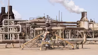
Michael: We're standing in front of the Featherstone Power Plant, a geothermal power plant.
That's enough electricity to power about 50,000 homes.
So the San Andreas Fault runs behind us and starts to step over down into other fault systems that end up going down into the Gulf of California.
And those step-overs are places where the crust is actually spreading apart.
So we call them pull-apart basins.
In these pull-apart basins, there's enough heat from the magma that it's actually heating up a deep brine that's accumulated over millions of years.
And so you have a mixture of steam and brine that get fed into the high pressure separator, and the steam goes to the top, and the brine falls to the bottom.
That steam then gets sent to the turbine and creates electricity that then gets sent into the grid.
Geothermal is renewable energy because it's recycled back into the ground and it's also base load energy, which means these plants run 24/7.
There are a total of 11 power plants operating down here, and they generate collectively a little over 400 megawatts.
They will be expanding this geothermal field pretty much by doubling its capacity over the next decade.
announcer: Scientists are also finding a way to mine the brine itself.
Michael: As the brine reacts with the sediment, it leeches many components, including a lot of trace metals out of those sediments.
announcer: One of those trace metals is lithium, an element in major demand globally for its use in batteries for electric vehicles and mobile devices.
Michael: So here at the Salton Sea, if we can extract lithium just by putting a lithium filter on the spent brine that's running through these plants, this would be the most environmentally friendly way of producing lithium in the world.
The United States supply chain of lithium right now is very fragile.
The environmental advantages of producing it here far outweigh the problems that we see in South America and Australia and China associated with lithium.
The Imperial Valley would benefit tremendously from both lithium production down here and lithium battery production.
That would create a lot of high paying, relatively high tech jobs that would really help the citizens of the Imperial Valley.
announcer: With a long list of issues to tackle, reversing the decline of the area is not going to be easy.
Tom: So how to solve this challenge of the receding Salton Sea?
One way to do it is to bring water back to the area.
Bringing in water from the ocean would sustain the level of the Salton Sea, cover 100% of the dust, provide for preservation of public health.
One option to refill the sea is to bring water from the Sea of Cortez.
That's 600 million to a billion in canal and pumping infrastructure.
That would bring in enough water at 1/2 million acre feet per year to sustain the elevation of the Salton Sea indefinitely.
One good solution to high salinity is to take heat from geothermal steam, remove salt from the Salton Sea at commercial quality, push the salinity back down to a marine level, where we can have a very productive ecosystem and a return to good recreational uses at zero net cost with the value of the salt that we extract in pure form from the Salton Sea.
announcer: Even if enough water is brought back to the Salton Sea to return it to a healthy level, it would still only be 1/30th of the size of the ancient lake at its peak.
Although this should not affect our fault lines, the area is still under seismic threat.
Caroline: It's really important to think about water quality, not just how we have a water supply issue.
Right now the state water board is treating the primary purpose of the Salton Sea as the agricultural sewage collection for the valley.
So that means all of the agricultural waters go into the Salton Sea virtually untreated.
You really don't have to ask the agricultural industry to change their practices.
It could just take a couple of sewage treatment plants to treat the sewage waters that go into the Salton Sea.
announcer: Sacramento is considering several environmental initiatives.
Should they be funded, the additional revenues would have a direct effect on the community and ecology.
William: For us, we just know that we'll deal with the area issue if an issue comes at the time that it happens.
Things have been in place for thousands of years, so we're just following along in that pattern.
How it is now, we're able to go back to visit our land, you know, our lands where we've been, our clan lands.
Now we're able to continue ceremonies there.
Linda: One thing I say about the sparkle on the sea, I don't need diamonds.
Those are my diamonds.
I love the Salton Sea.
It's a magical place.
It's worth saving.
Sean: We need to heal the Salton Sea.
We need to protect the sea.
We need to preserve the sea and all the animals that are associated with the sea.
Linda: I have hope in the young people.
They said, "You know what?
We can find a way to save the sea, and we're going to do it," so they're my hope.
announcer: The mysterious Salton Sea boasts a wild and storied history.
With some help, its secrets could ensure a prosperous future as well.
♪♪♪ ♪♪♪ ♪♪♪ announcer: This program was made possible in part by a grant from Anne Ray Foundation, a Margaret A. Cargill Philanthropy.
...
Episode 1: Salton Secrets (Preview)
Video has Closed Captions
Preview: Ep1 | 30s | The mysteries of the Salton Sea including shipwrecks, gold, and a link to earthquakes. (30s)
Providing Support for PBS.org
Learn Moreabout PBS online sponsorship
- Science and Nature

Explore scientific discoveries on television's most acclaimed science documentary series.

- Science and Nature

Capturing the splendor of the natural world, from the African plains to the Antarctic ice.


Support for PBS provided by:
Off the Beaten Path is a local public television program presented by PBS SoCal